ARTICLE I PURPOSE AND ENACTMENT
ARTICLE II SHORT TITLE
ARTICLE III DEFINITION OF TERMS
ARTICLE IV ESTABLISHMENT OF DISTRICTS
ARTICLE V APPLICATION OF ORDINANCE
ARTICLE VI GENERAL CONDITIONS
ARTICLE VII USE REQUIREMENTS BY DISTRICT
ARTICLE VIII AREA, YARD AND HEIGHT REQUIREMENTS
ARTICLE IX SPECIAL PROVISIONS
ARTICLE X SIGNS
ARTICLE XI CONDITIONAL USES AND VARIANCES
ARTICLE XII ZONING ADMINISTRATION ENFORCEMENT AND PENALTIES
ARTICLE XIII AMENDMENTS
ARTICLE XIV DISCLOSURE REQUIREMENTS
ARTICLE XV LEGAL STATUS PROVISIONS
Editor's note(s)—Printed herein is the zoning ordinance of the county, adopted December 8, 2020. Prior versions of the zoning ordinance were adopted July 17, 2007; December 30, 2009; effective April 6, 2016; and February 16, 2017; October 2, 2017; August 7, 2018; December 11, 2018; and July 14, 2010. Amendments are indicated by parenthetical history notes following amended provisions. The absence of a history note indicates that the provision remains unchanged from the original. Obvious misspellings and punctuation errors have been corrected without notation. Additions made for clarity such as consistent state statute citations and catchline modifications are indicated by brackets.
The following analysis entitled Zoning Ordinance, Greene County, Georgia, is designed to provide the governing authority or authorities of Greene County with a regulatory measure designed to meet present-day and anticipated future needs for the promotion of the health, safety, morals, convenience, order, prosperity or general welfare of the county by the control of such matters as the location, height, bulk, number of stories and size of buildings and other structures, the percentage of a lot which may be occupied, the sizes of yards, courts, and other open spaces, the density and distribution of population, and the uses of buildings, structures, and land for trade, industry, residence, recreation, agriculture, forestry, conservation, water supply, sanitation, protection against floods, public activities, and other purposes.
This ordinance is made in accordance with a comprehensive plan and shall be designed to lessen congestion in the street, to secure safety from fire, panic, and other dangers, to promote health and the general welfare, to provide adequate light and air, to prevent the overcrowding of land, to avoid undue concentration of population, to facilitate the adequate provision of transportation, water, sewerage, schools, parks, and other public requirements.
Said ordinance is made with reasonable consideration, among other things of the character of the district and its peculiar suitability for particular uses, and with a view to promoting desirable living conditions and the sustained stability of neighborhoods, protecting property against blight and depreciation, securing economy in governmental expenditures, conserving the value of buildings and encouraging the most appropriate use of land and other buildings and structures throughout Greene County.
Sec 1.2 Legislative Authority
Sec 1.3 Method Of Regulation
Sec 1.4 Jurisdiction
This ordinance is for the purpose of setting forth standards and permissible uses designed to conserve and protect the natural, economic and scenic resources of Greene County; health, aesthetics, morals, convenience, order, prosperity and general welfare; to provide adequate light and air; to prevent the overcrowding of land; to promote desirable living conditions and stability of neighborhoods; to facilitate the adequate provision of transportation, water, sewerage, schools, parks, and other public requirements by dividing Greene County into districts of such size and shapes as may be best suited to carry out the purposes of the legislative act and of this ordinance.
(Ord. of 12-8-2020, § 1(Exh. A))
The Board of Commissioners of Greene County, Georgia under the authority of Article IX, Section 2, Paragraph 4 of the Constitution of the State of Georgia and Chapter 66, Title 36 of the Official Code of Georgia Annotated, and for the purpose of promoting the health, safety, morals, convenience, order, prosperity, or the general welfare of the county and designed to lessen congestion in the streets; to secure safety from fire, panic, and other dangers; to avoid undue concentration of population; ordains and enacts into law the Official Zoning Ordinance for unincorporated Greene County, (for planning, zoning and subdivision control purposes).
(Ord. of 12-8-2020, § 1(Exh. A))
The Board of Commissioners of Greene County, Georgia, as authorized by the Constitution of the State of Georgia, adopts zoning regulations for the following purposes: to define certain words used therein; to create zoning districts; to regulate the location of trades, professions, businesses, and industries; to regulate the density in distribution of population; to provide for the gradual elimination of nonconforming uses of land, buildings and structures; to provide for the method of administration, amendment and enforcement; to provide for the imposition of penalties for violations; repeal conflicting ordinances and resolutions; and for other purposes.
(Ord. of 12-8-2020, § 1(Exh. A))
This zoning ordinance shall govern the use of all land and development within the unincorporated limits of Greene County, Georgia and within the limits of any inactive municipality in accordance with O.C.G.A. § 36-70-5.
(Ord. of 12-8-2020, § 1(Exh. A))
This ordinance shall be known and may be cited as "The Zoning Ordinance for Greene County, Georgia".
(Ord. of 12-8-2020, § 1(Exh. A))
Except as otherwise provided herein, all words shall have their customary dictionary meaning. The present tense includes the future tense. The singular number includes the plural and the plural includes the singular. The word "person" includes a firm, corporation, association, organization, trust or partnership. The word "lot" includes "plot" or "parcel". The word "building" includes any structure having a roof supported by columns, walls, or by other means, and intended for shelter, housing, or enclosure of any individual, animal, process, equipment, goods, or materials of any kind. The word "shall" is always mandatory. The word "used" or "occupied", as applied to any land or building, shall be construed to include the words "intended, arranged, or designed to be used or occupied". The term "erected" shall be deemed also to include "constructed", "reconstructed", "altered", "placed", or "moved". The word "land use" and "use of land" shall be deemed also to include "building use" and "use of building". The word "map" means the "Official Zoning Map of Greene County, Georgia", dated 1986, and as may be amended.
When used in this Ordinance, the following words and phrases shall have the meaning given in this Section.
Accessory building. A subordinate building, the use of which is incidental to, and reasonably related to, a main building on the same lot or to the primary use of the property. The accessory building shall be of a size and nature customarily incidental and subordinate to the principal. Accessory buildings shall not include open air structures such as gazebos, pole barns, and pavilions, provided that no such structure has constructed finished floor area exceeding two hundred (200) square feet. Signs and fences are not to be considered as accessory buildings. A "detached" accessory building shall be one that does not have a common wall, attached walkway, or roof connection with the main building on the same lot.
Accessory structure. A structure that is accessory to and incidental to that building in which is conducted the main or principal use of the lot on which said building is situated.
Accessory use. A use on the same lot with, and of a nature customarily incidental and subordinate to the principal use.
Addition. An extension or increase in floor area, number of stories or height of a building or structure.
Agriculture or agricultural. A parcel used primarily for soil-dependent cultivation of agricultural crop production, the raising of livestock excluding poultry and other Confined Animal Feeding Operations, growth of a field, or forestry, not intended for residential subdivisions.
Airport. An area of land designed and set aside for landing and take-off of aircraft, including all necessary facilities for the housing and maintenance of aircraft.
Alteration. Any construction, retrofit or renovation to an existing structure other than repair or addition that requires a permit. Also, a change in a building, electrical, gas, mechanical or plumbing system that involves an extension, addition or change to the arrangement, type or purpose of the original installation that requires a permit.
Animal shelter. A public or private facility exclusively for the temporary housing of stray or unwanted domestic animals.
Apartment. A suite of 2 or more rooms and a bath, which is designed according to the State Minimum Standard Codes as amended from time to time, and designed or intended for occupancy by one family or one person doing its cooking therein; or, as in the case of an "efficiency" or "studio apartment," one single room that combines the bedroom, living room and kitchen, with only the bathroom being private. For zoning purposes, an apartment is regarded as a dwelling unit. A structure containing two (2) apartments is a duplex. A structure containing 3 or more apartments is a multi-family dwelling.
Applicant. Any person who applies for a rezoning action, variance, conditional use permit, sign permit, or building permit, and any attorney or other person representing or acting on behalf of a person who applies for the same.
Assisted living home. See Personal care home.
Automobile repair garage. An establishment for performing vehicle repair and maintenance, including but not limited to, brakes, oil changes, lubrication, transmission, engine, belts, hoses, inspections, and tire mounting and installation.
Automotive sales lot. Storage and display for sale of automobiles, motorcycles, recreational vehicles, or other motorized vehicles. Motorized vehicles for sale will typically be stored outside. All other activities must be in an enclosed building.
Automobile service station. Any area of land, including structures thereon, used primarily for the retail sale of gasoline or oil, automobile accessories and incidental services including facilities for lubricating, or otherwise servicing automobiles, but excluding painting or major repairs.
Bed and breakfast. A single family dwelling unit, other than a hotel, motel or boarding house, or portion thereof, where short-term lodging rooms and meals are provided to registered guests for compensation and where the operator of the Bed and Breakfast lives in the same dwelling unit.
Block. A contiguous piece or parcel of land entirely surrounded by public highways or streets, but excluding alleys.
Board of Commissioners. Greene County Board of Commissioners.
Boarding house. A building other than a hotel where lodging and meals are provided for compensation or by pre-arrangement for at least three (3) and not more than ten (10) persons at any one time. A building other than a hotel is not considered a boarding house by reason of a contribution to or an expense sharing arrangement with the owner or tenant occupying the dwelling by a person related by blood or marriage.
Body shop. An establishment providing major repair or body work services, including, but not limited to, collision repair, other body work, painting services, tire recapping.
Borrow pit. An extracted area where naturally occurring earthen materials are to be removed for use as ordinary fill at another location.
Buffer area. A landscaped or naturalized area used to separate and partially obstruct the view of a development from adjacent or contiguous development. This area shall be in addition to any required area, yard, and height requirements for the zoning district as specified in Article VIII.
Building. Any structure, either permanent or temporary, above or below ground having roof or other covering, designed, built or used as a shelter or enclosure for persons, animals, or property of any kind.
Building, existing. Existing building is a building erected prior to the adoption of this code, or one for which a legal building permit has been issued.
Building, height of. The vertical distance from grade plane to the average height of the highest roof surface.
Building inspector. Greene County Building Inspector or such other position as may have substantially the same duties, responsibilities, and authority.
Building line. The line established by law, beyond which a building shall not extend, except as specifically provided by law.
Building official. The officer or other designated authority designated by the Board of Commissioners charged with the administration and enforcement of this ordinance, or a duly authorized representative of the Building Official.
Building, principal. A building, in which the primary use of the lot on which the building is located is conducted.
Burial ground. An area dedicated to and used for interment of human remains. The term shall include privately owned burial plots, individually and collectively, once human remains have been buried therein. The fact that the area was used for burial purposes shall be evidence that it was set aside for burial purposes.
Business entity. Any corporation, partnership, limited partnership, firm, enterprise, franchise, association, or trust.
Campaign contribution. A contribution as defined in paragraph (7) of O.C.G.A. § 21-5-3.
Campground. An area or tract of land on which accommodations for temporary occupancy are located or may be placed, including cabins, tents, and major recreational equipment, and which is primarily used for recreational purposes. (Cabins, tents or major recreational equipment are not "open air and do not contain natural character".)
Car wash. A business establishment engaged primarily in the washing and/or waxing of any vehicle (including but not limited to cars, trucks, motorcycles, boats, personal watercraft, all-terrain vehicles, etc.), either by the patron, by others, by automated machinery or by some combination thereof.
Caretaker dwelling or employee residence. A single-family dwelling placed on the same lot or tract of land as the principal residence of the owner of an agricultural operation for use by a farm worker.
Carport. See Garage, private.
Cemetery, abandoned. A cemetery which shows signs of neglect including, without limitation, the unchecked growth of vegetation, repeated and unchecked acts of vandalism, or the disintegration of grave markers or boundaries and for which no person can be found who is legally responsible and financially capable of the upkeep of such cemetery.
Cemetery, religious institution. A plot of ground, building, mausoleum, or other enclosure owned by a religious institution and used for the burial of deceased persons who are generally members of that religious institution.
Cemetery, private. Any plot of ground, building, mausoleum, or other enclosure used for the burial of deceased persons of one collateral line of descent.
Cemetery, public. A plot of ground, building, mausoleum, or other enclosure not located on property owned by a religious institution but used for the burial of deceased persons.
Change of occupancy. A change in the use of a building or portion of a building that involves a change in the application of the requirements of the Standard Building Codes or this Ordinance.
Church. See Religious institution.
Clinic. A building where human patients, who are not lodged overnight, are admitted for examination and treatment.
Club. Buildings and facilities owned or operated by a corporation, association, or persons for social, educational or recreational purposes.
Commercial use. An occupation, employment, or enterprise that is carried on for profit by the owner, lessee, or licensee.
Community center. A place, structure, area, or other facility used for and providing fraternal, social, and/or recreational programs generally open to the public and designed to accommodate and serve significant segments of the community.
Comprehensive plan. The "Comprehensive Plan for Greene County and the cities of Greensboro, Siloam, Union Point, White Plains, and Woodville, adopted August, 1994," and as may be amended.
Conditional use. A use which is not permitted inherently but which may be permitted within a zoning district subject to approval by the Board of Commissioners.
Conditional use permit. The permit issued by the County following approval of the conditional use by the Board of Commissioners.
Condominium. An estate in real property consisting of an undivided interest with other purchasers in the common grounds together with a separate interest in a dwelling unit located on the common grounds.
Confined animal feeding operation. Any animal feeding operation where animals are fed at the place of confinement and crop or forage growth in production is not sustained in the area of confinement, and the number of animals, including chickens, exceeds 999 at any given time.
Confinement area. Any building, structure, or other facility in which chickens, hens, chicks, any type of poultry, or hogs are raised, hatched, or maintained in a live condition as part of a commercial operation involving the sale of such birds or animals on a large-scale basis, such as contract growers.
Conservation areas. Environmentally sensitive and valuable lands protected from any activity that would significantly alter their ecological integrity, balance, or character, except in cases of overriding public interest. Conservation areas include groundwater recharge areas, watersheds, wetlands, and river corridors.
Contiguous property. Two or more parcels of land with a common boundary or separated solely by a public or private roadway, or other public or private right-of-way, waterway or water body.
Convenience center. A location provided by the County government for the use of the citizens of Greene County to dispose of household waste in the proper provided receptacles.
Convenience store. A one-story, retail store containing less than 2,000 square feet of gross floor area that is designed and stocked to sell primarily food, beverages, and other household supplies to customers who purchase only a relatively few items (in contrast to a supermarket). It is designed to attract and depends upon a large volume of stop-and-go traffic. Illustrative examples of convenience stores are those operated by "7-11" and "Golden Pantry."
County. Greene County, Georgia.
County official. Any member of the Greene County Board of Commissioners or Greene County Planning Commission.
Court. An open, uncovered space, unobstructed to the sky, bounded on three or more sides by exterior building unit or other enclosing devices
Day care center. A building operated by a person, society, agency, corporation, institution, or group that receives for group care fewer than twenty-four (24) hours per day without transfer of legal custody, children under eighteen (18) years of age.
Day care home. A private dwelling operated by any person who receives pay for supervision and care, fewer than twenty-four (24) hours per day, without transfer of legal custody, of three (3) but not more than six (6) children under eighteen (18) years of age who are not related to such person and whose parents or guardians are not residents in the same private dwelling.
Density. The number of dwelling units per gross acre of land.
District. A section of Greene County, Georgia where the zoning ordinance is uniform.
Dry cleaners. A business that provides laundry cleaning, excluding self-service, and contains on the premises, equipment necessary for laundry processing.
Dwelling, multi-family. A building containing at least 3 dwelling units designed for residential use by 3 or more families living independently of each other. This includes apartments but not group homes, row houses, condominiums, or townhouses.
Dwelling, single-family. A structure including site built, modular, manufactured homes, and mobile homes that contain one (1) dwelling unit designed for residential use that is surrounded by open space on the same lot. "Dwelling, Single-family" does not include "Dwelling, Single-Family, Detached."
Dwelling, single-family, detached. A structure including a site built or modular home that contains one (1) dwelling unit designed for residential use that is surrounded by open space on the same lot, which meets or exceeds the following standards:
- Minimum width in excess of sixteen (16) feet.
- Minimum square footage required by the zone in which located.
- The roof shall have a minimum roof pitch greater than 2:12 and shall have a surface of wood shakes, asphalt composition, wood shingles, concrete, plastic composite, metal sheet panels, terracotta, fiberglass or metal tiles, slate, built up gravel materials. The roof overhang must be at least 1 foot when measured from the vertical side on all sides.
- The exterior siding materials shall consist of wood, masonry, concrete, stucco, masonite, metal or vinyl lap. Exterior walls are only permitted to have vinyl lap siding if there are more than thirty (30) feet between the foundation walls of the buildings on adjacent lots.
- Be attached to a permanent foundation.
- Be constructed according to standards established by the State Minimum Technical Codes as amended from time to time.
- Be designed and used, or held ready for use, as a permanent residence by one family unit that shall not be used for any commercial purpose except as allowed in § 9.7 of this ordinance.
Dwelling, two-family (duplex). A structure containing 2 dwelling units designed and arranged for residential use by 2 families living independently of each other.
Dwelling unit. A single unit providing complete independent living facilities for one or more persons, including permanent provisions for living, sleeping, eating, cooking and sanitation.
Easement. A grant of 1 or more property rights by the owner to, or for the use by, the public, a corporation, or another person or entity.
Family. One (1) or more individuals permanently occupying a dwelling unit and living as a single housekeeping unit, as distinguished from persons occupying a boarding house, group home, or hotel, as defined in this ordinance.
Feed lot. A type of outdoor (only) animal feeding operation (AFO) which is used for the efficient raising and finishing of livestock, notably beef cattle, but also swine, horses, sheep, turkeys, chickens or ducks prior to slaughter.
Financial interest. All direct ownership interests of the total assets or capital stock of a business entity where such ownership interest is 10 percent or more.
Flea market. An occasional or periodic sales activity held within a building, structure, or open area where groups of individual sellers offer goods, new and used, for sale to the public, not to include private garage sales.
Floor area. The sum of the gross horizontal areas of the total number of floors of a building measured from the exterior faces of the exterior walls or from the centerline of the walls separating two buildings, including stairwells and elevator shafts, but not including: attic space providing headroom for less than seven (7) feet, unusable basement or cellar space not used for retailing, uncovered steps or fire escape, open porches, accessory water or cooling towers, accessory off-street parking spaces, or accessory off-street loading berths.
Floor area, gross. The floor area within the inside perimeter of the exterior walls of the building under consideration, exclusive of vent shafts and courts, without deduction for corridors, stairways, ramps, closets, the thickness of interior walls, columns or other features. The floor area of a building, or portion thereof, not provided with surrounding exterior walls shall be the usable area under the horizontal projection of the roof or floor above. The gross floor area shall not include shafts with no openings or interior courts.
Floor area, net. The actual occupied area not including unoccupied accessory areas such as corridors, stairways, ramps, toilet rooms, mechanical rooms and closets.
Frontage. The distance for which the front boundary line of the lot and the street line are coincident. For the purpose of corner lots, all sides of a lot adjacent to streets shall be considered frontage.
Frontage street. The street coincident to the front boundary line of the parcel.
Garage, parking. A building or portion thereof designed or used for storage of motor-driven vehicles.
Garage, private. An accessory building or a portion of a principal use building used for parking or storage of motor vehicles of the principal building's occupants. A carport is considered a private garage.
Garage, repair. A building and premises designed or used for the purpose of service or commercial repair of motor vehicles. All body work and painting shall be conducted within fully enclosed buildings. The storage of junk, wrecked vehicles, dismantled parts or supplies shall be solely for the purpose of repairing motor vehicles and not as a salvage or junkyard business. The storage of junk, wrecked or unclaimed vehicles, dismantled parts or supplies shall not be visible beyond the premises.
Garage apartment. A dwelling unit for 1 family erected above a private garage detached from the principal dwelling.
Grade plane. A reference plane representing the average of the finished ground level adjoining the building at all exterior walls. Where the finished ground level slopes away from the exterior walls, the reference plane shall be established by the lowest points within the area between the building and the lot line or, where the lot line is more than 6 feet (1829 mm) from the building between the structure and a point 6 feet (1829 mm) from the building.
Ground level, average. The height of the center of the nearest public road.
Group home. A residence under the ownership and supervision of a public, educational, or governmental institution occupied or intended for occupancy by several unrelated persons or families but where separate cooking facilities are not provided for such resident persons or families.
Guest house. A dwelling unit for temporary guests in a building accessory to a detached, single-family dwelling, and which is not rented or otherwise used or occupied as a separate dwelling. A guest house is an accessory use to a detached, single-family dwelling.
Health department. Greene County Health Department.
Home occupation, residential. An occupation or profession conducted in accordance with § 9.7.1 of this ordinance and for financial gain, which is clearly subordinate to the use of the dwelling and which does not change the character or occupancy classification thereof.
Home occupation, rural. An occupation or profession conducted in accordance with 9.7.2 of this ordinance and entirely within a dwelling unit or accessory building and for financial gain, which is clearly subordinate to the principal use of the parcel and which does not change the character or occupancy classification thereof.
Home office. An office use conducted entirely within a dwelling unit, which is carried on solely by the unit's occupant and is incidental and secondary to the principal use of the dwelling in which does not change the character or occupancy classification thereof. The office may be for the purpose of service or trade workers who customarily work at various locations, such as electricians, plumbers, appraisers, real estate salespersons, or individuals who work at home, such as writers or computer programmers. "Home Office" shall not include any business that involves the sale, manufacture or repair of merchandise on the premises. Home Offices shall also not include any business requiring access by the public, including, but not limited to, customers, clients or vendors.
Homestead compound. A form of traditional rural development which provides for the placement of additional single-family detached dwelling units on a single parcel of land owned usually by the same family.
Homestead farm. A low-density single-family lot that is at least three acres on which limited farming activities and horses for personal pleasure and/or leisure are permitted. No commercial farming activities are allowed on the lot.
Hotel. Any building, group of buildings, or structure offering for rental rooms for overnight occupancy or accommodations for ten (10) persons or more for compensation which may, or may not, provide additional services such as restaurants, meeting rooms, and recreational facilities.
Industrial park. A tract of land subdivided and developed according to a comprehensive development plan in a manner that provides a park setting for industrial establishments.
Industrialized building. A factory fabricated transportable building consisting of units designed for incorporation into a permanent structure at a building site on a permanent foundation to be used for residential purposes. A modular home shall be certified by the manufacturer to meet the approval of the State Building Administration Board (SAAB) to meet the same requirements as a site built home within Greene County.
Institution. A non-profit corporation or a non-profit establishment.
Junk. Old or scrap copper, brass, rope, rags, batteries, paper, trash, rubber debris or waste, junked, dismantled, or wrecked automobiles, or parts thereof, or iron, steel, and old scrap ferrous or nonferrous metal.
Junk yard. A lot, land or building, or part thereof, used primarily for the collection, storage, and sale of waste paper, rags, scrap metal, or discarded material, or for the collecting, dismantling, storage, and salvaging of machinery or vehicles not in running condition, or for the sale of parts thereof.
Junked vehicle. Any wrecked, dismantled, or non-operating motorized vehicle that does not bear a current license plate. Also includes non-operational farm equipment excluding farm implements.
Kennels. Any location where, for commercial purposes, 4 or more adult dogs, cats, rabbits or other domestic animals are kept for the purpose of boarding, caring for, raising, grooming, breeding, training or sale.
Kindergarten. A school for pre-elementary school children ranging in age from 4 through 6 years, which operates for less than 4 hours per day.
Laundromat. A business that provides home-type washing, drying, ironing machines or coin operated dry cleaning machines for hire and use by customers on the premises contained within an enclosed building.
Laundry pick-up. A business that provides only for the convenience of taking and picking up laundry and which does not have any on-site equipment for processing laundry.
Loading space. A space within the principal use or on the same lot that provides for standing, loading or unloading of trucks and other carriers.
Lodging house. See Boarding house.
Lot. A portion of, or parcel of land separated from other portions or parcels by description, metes and bounds, intended for transfer of ownership or for building development and having a separate tax parcel reference number designated in the office of Greene County Tax Commissioner or Greene County Tax Assessor.
Lot, corner. A lot abutting 2 or more public streets or county maintained roads at their intersection.
Lot, double frontage or through lot. A lot with frontage on 2 public streets and/or county maintained roads that do not intersect at a point abutting the property.
Lot, interior. A lot other than a corner lot.
Lot line, front. The front lot line is generally opposite the rear lot line. The front lot line would be coincident to the frontage street.
Lot line, rear. The rear lot line is generally opposite the front lot line. If the rear lot line is less than 10 feet in length or if the lot comes to a point at the rear, the rear lot line shall be deemed to be a line parallel to the front lot line, not less than 10 feet long, and lying wholly within the lot and farthest from the front lot line.
Lot of record. A lot whose existence, location, and dimensions have been legally recorded or registered in a deed or on a plat in the office of the Clerk of the Superior Court of Greene County.
Lot width. The horizontal distance between one side lot line and the other side lot line measured at right angles at the minimum front setback line. The Planning Commission or Zoning Administrator may establish the location at which the lot width shall be measured when considering irregularly shaped lots.
Lunch counter. A retail establishment where the preparation and serving of food is not the principal business of the retail establishment, defined as not generating the largest percentage of gross sales or occupying the largest percentage of the retail floor area. Food served in the establishment shall be unpackaged, in individual servings, and in a ready-to-consume state. Customers shall be served while seated at tables or counters located within the building.
Major utility facility. All utility facilities other than minor utilities. Including public utilities serving regional areas and public utility service and storage yards. Examples include, but are not limited to, uses such as electrical substations, water and sewer treatment facilities, and water towers. This definition excludes public utility transmission lines.
Manufactured home. A structure defined by and constructed in accordance with the National Manufactured Housing Construction and Safety Standards Act of 1974 as amended, 42 U.S.C. § 5401, et seq. The definition at the date of adoption of this part is as follows:
- "Manufactured Home" means a structure, transportable in one or more sections, which in the traveling mode, is eight (8) body feet or more in width or forty (40) body feet or more in length, or, when erected on site, is three hundred twenty (320) or more square feet, and which is built on a permanent chassis and designed to be used as a dwelling with or without a permanent foundation when connected to the required utilities, and includes the plumbing, heating, air-conditioning, and electrical systems contained therein. Except that such term shall include any structure which meets all the requirements of this paragraph except the size requirements and with respect to which the manufacturer voluntarily files a certification required by the Secretary and complies with the standards established under this title.
Manufactured home space. Land within a manufactured home park that is reserved or leased for the placement of an individual manufactured home, accessory structures and the exclusive use of its occupants.
Manufactured home park. A tract of land that is used, designated, maintained, or held out for rent to accommodate 3 or more manufactured homes. Manufactured homes located in a manufactured home park are used only to provide living and sleeping accommodations. A manufactured home park does not include an automobile or manufactured home sales lot on which unoccupied manufactured homes are parked for inspection or sale.
Manufacturing, processing and assembling. The mechanical or chemical transformation of materials or substances into new products. The land uses engaged in these activities are usually described as plants, factories or mills and characteristically use power driven machines and materials handling equipment. Establishments engaged in assembling component parts of manufactured products are also considered under this definition if the new product is neither a fixed structure nor other fixed improvement. Also included is the blending of materials such as lubricating oils, plastic resins or liquors.
Marina. A facility for storing, servicing, fueling, berthing, and securing and launching of private pleasure craft that may include the sale of fuel and incidental supplies for the boat owners, crews, and guests.
Mechanical shop. See Body Shop.
Member of the family. The spouse, mother, father, brother, sister, son, or daughter of a county official. This definition applies to Article XIV only.
Mine development. The preparation of a surface or subsurface area for commercial mining including non-commercial extraction of ore bearing or non-ore bearing rock, excavation for open pit, declines, adits, drifts, shaft construction, or any surface construction or excavation.
Mining. The removal from the earth of materials, minerals and other solid matter that will be further processed, refined, cleaned or altered in any way and then incorporated into manufactured products either in the County or other commercial markets. Water acquired for personal or commercial uses and earthwork necessary for normal grading operations are exempted from this definition.
Mining operation/mineral extraction/material extraction, existing. A mineral/material extraction or surface mining operation with a valid business license and on which active physical operations on site exist at the time this Ordinance is adopted; or any such proposed operation for which a valid Surface Mining Permit has been issued by the Georgia Environmental Protection Division and for which a reclamation bond has been funded, prior to the adoption of this Ordinance.
Mini-warehouse. A building consisting of individual, small, self-contained units that are leased for the storage of business and household goods or contractor's supplies.
Minor utility facility. Any structures or facility (other than buildings, unless such buildings are used as storage incidental to the operation of such structures or facilities) owned by a governmental entity, a nonprofit organization, a corporation, or any entity defined as a public utility for any purpose by the Georgia Public Service Commission and used in connection with the production, generation, transmission, delivery, collection, or storage of water, sewage, electricity, gas, oil, or electronic signals. Examples include, but are not limited to, pump stations, community well houses and above ground utility cabinets. Minor utilities are exempt from minimum lot size and setback requirements. Excepted from this definition are Major Utilities.
Mobile home. A transportable, factory-built structure designed to be used as a year-round residential dwelling and built prior to the enactment of the Federal Manufactured Housing Act of 1974, which became effective June 15, 1976.
Modular home. See Industrialized building.
Motel. A building or a group of buildings designed and used primarily for offering transient lodging accommodations and having a parking place adjacent to each sleeping room and having separate outside entrances for each guest room. A motel is used primarily for automobile transients and includes such terms as "auto court" and "motor lodge" but not "boarding house" as defined in this section.
Non-conforming building or structure. Any lawfully existing building or structure which does not conform to these ordinances governing the type, bulk, location, height or size of buildings or structures permitted in the district prior to the adoption of this ordinance but which is in full compliance with all applicable federal, state and local laws, rules and ordinances, and for which all required federal, state and local permits have been issued.
Non-conforming lot. A lot, the area, width, or other characteristics of which fails to comply with applicable ordinances and which was of record and in full compliance with all applicable federal, state and local laws, rules and ordinances prior to the enactment of these or other ordinances, but which does not comply with the requirements of this ordinance.
Non-conforming use. A lawful use of land that does not comply with the use ordinance for its zoning district but which complied with applicable ordinances at the time the use was established.
Nursing home. A facility for 3 or more unrelated ill or aged persons not operating as the functional equivalent of a family, that provides food, shelter, and 24-hour medical care for compensation in addition to meeting the physical, emotional, and social needs of the unrelated aged or ill persons.
Off-street parking. An area exclusive of a public or private thoroughfare where motor vehicles may be stored for the purposes of temporary, daily, or overnight parking. Parking within the road or street right-of-way is not Off-Street Parking.
Open space. Land that is designed, developed, or reserved for recreation, gardens, resource protection, amenity, or buffers that may or may not be accessible to the residents of the development and/or the public. In no event will any area of a privately owned residential lot, any existing or future road rights-of-way, any off street parking or loading space area be counted as open space. To encourage the use of parkways and green pathways, areas within rights-of-way that are in excess of the required Greene County right-of-way widths as stipulated in the Zoning Ordinance and in the Subdivision Regulations may be counted toward open space requirements. To encourage the use of buffers around commercial tracts, within the Commercial Planned Unit Development District, designated buffers and parks may be counted as open space.
Opponent. Any person who opposes a rezoning action or any attorney or other person representing or acting on behalf of a person who opposes a rezoning action.
Oppose. To appear before, discuss with, or contact, either orally or in writing, a Greene County official and argue against a rezoning action.
Overburden means all of the earth and other materials which lie above natural deposits of ores or minerals, and includes all earth and other materials disturbed from their natural state in the process of surface mining.
Permitted use. Any use by right that is specifically authorized in a particular zoning district.
Person. An individual, partnership, committee, association, corporation, labor organization, or any other organization or group of persons.
Personal care home. A building or group of buildings, whether operated for profit or not, which undertakes through its ownership or management to provide or arrange for the provision of housing, food service, and one or more personal services for 2 or more adults who are not related by blood or marriage to the owner or administrator of the home. The facility must meet all requirements of Article 9.21 of this ordinance and must comply with all regulations and requirements of the State of Georgia Department of Human Resources, Federal Government and of the International Building Code. Personal services includes, but is not limited to, individual assistance with or supervision of self-administered medication and essential activities of daily living such as eating, bathing, grooming, dressing, and toileting. This term does not include buildings that are devoted to independent living units that include kitchen facilities where residents have the option of preparing and serving some or all of their own meals or boarding facilities which do not provide personal care.
Personal care homes are categorized as follows:
- Family personal care home means a home for adults in a family-type residence, non-institutional in character, which offers care to 2 through 6 persons. Excluding temporary doctor ordered in home hospice care for immediate family members.
- Group personal care home means a home for adults in a residence or other type building(s), non-institutional in character, which offers custodial care but does not provide medical care to 7 through 15 persons.
- Congregate personal care home means a building or part thereof that contains sleeping units where residents share bathroom or kitchen facilities, or both for adults offering care to 16 or more persons.
- Memory care unit or home means the specialized unit within any personal care home or home that either holds itself out as providing additional or specialized care to persons with diagnoses of probable Alzheimer's Disease or other dementia who may be at risk of engaging in unsafe wandering activities outside the unit or home (eloping) or charges rates in excess of those charged other residents because of cognitive deficits which may place the residents at risk of eloping. Any personal home containing memory care unit or units must be located in a district that designates memory care units or homes as a permitted or conditional use.
Planning commission. Greene County Planning Commission.
Plat. A sketch, map or survey of a lot, tract or parcel of land including lot lines, street rights-of-way and easements drawn to scale, with the dimensions of these features inscribed thereon.
Play school. A school for pre-kindergarten children ranging in age from 3 to 4 years of age.
Principal use. The primary purpose for which land or a building is used.
Professional. When used in connection with "use" and "occupancy", a use or occupancy by persons generally engaged in rendering personal, executive, sales, or administrative services or activities, including accountants, architects, professional engineers and land surveyors, doctors, lawyers, insurance offices, real estate offices, religious organizations, stock brokers and administrative agencies considered professional in character. The term, however, does not include repairs or sales of tangible personal property stored or located within the building nor any use that would create any loud noise or noxious odors within Greene County.
Property interest. The direct ownership of real property, including any percentage of ownership less than total ownership.
Radio operated controller: A device used to operate a security gate or barrier that is equipped with a radio receiver capable of receiving signals from a sheriff’s department, fire department, and emergency medical services’ radio transceivers that allow emergency responders and other necessary on-duty employees to open the security gate or barrier or blocking device by use of the equipment.
Real property. Any tract or parcel of land and, if developed, any buildings or structures located on the land.
Reclamation means the reconditioning or rehabilitation of affected land under an approved mining land use plan.
Recreational campgrounds. Any public or private property that is used on a continuing basis for camping, or camping in conjunction with fishing or hunting shall be considered a recreational campground.
Recreational development means the modification of the natural or existing environment to accommodate public facilities designed and used for recreation by the public and/or members only.
Recreational vehicle. A vehicular type unit primarily designed for recreation, camping, travel or seasonal use that has its own motor power or is mounted on or towed by another vehicle. The basic entities are: travel trailer, folding camping trailer, park trailer, truck camper, motor home, and custom van conversions.
Recreational vehicle park. Any parcel where 2 or more recreational vehicle sites are located, established, or maintained for occupancy by recreational vehicles or tents, as temporary living quarters by the general public for recreation or vacation purposes.
Recreational vehicle site. A plot of ground within a recreational vehicle park intended for the accommodation of either a recreational vehicle, tent, or other individual camping unit on a temporary basis. Sites shall be rented by the day or week only, and the occupant of the space and his/her vehicle, tent or camper shall not remain in the same recreational vehicle park for more than 30 days in a 60-day period.
Recycling center. A facility designed and operated to receive, store, or process recyclable materials that have been separated from residual solid waste. Materials may include, but are not limited to: newspaper, corrugated cardboard, aluminum, glass, metal, plastic, motor oil and batteries.
Religious institution. A religious institution that has been granted 501-C tax exempt status by the Internal Revenue Service and whose property is deemed tax exempt by the Greene County Tax Assessor.
Removal. The actual process of digging or otherwise removing the substance being moved.
Restaurant. An establishment where food and beverages are sold for consumption on the premises. A snack bar or refreshment stand at a public or non-profit community swimming pool, playground, or park operated solely for the convenience of patrons of the facility is not a restaurant.
Restaurant, drive-in. An eating or drinking establishment that caters to motor-driven vehicle business where the person being served consumes his food or drink while sitting in a motor driven vehicle, as opposed to a restaurant serving exclusively inside an enclosed building.
Restaurant, family. An establishment, privately owned and operated where food and beverages are sold primarily for consumption on the premises and is not part of a chain restaurant or franchise.
Restaurant, fast-food. An establishment that offers quick food service, which is accomplished through a limited menu of items already prepared and held for service, or prepared, fried, or griddled quickly, or heated in a device such as a microwave oven. Orders are not generally taken at the customer's table and food is generally served in disposable wrapping or containers.
Rezoning action. An action by the Board of Commissioners adopting an amendment to the zoning map that has the effect of rezoning real property from one zoning district to another.
Right-of-way. That area, distinguished from an easement, for the present or future use of roads, streets, highways and utilities, together with its drainage facilities and other supporting uses and structures.
Right-of-way line. Designated limits of a right-of-way, whether such right-of-way is established by usage, recorded easement, deed, dedication or by an official right-of-way map of Greene County, Georgia.
School. A public or private facility that provides a curriculum of elementary and secondary academic instruction including kindergartens and pre-kindergartens.
Screening. A method where a view of one site is shielded, concealed, or hidden from another site. Screening techniques include fences, walls, berms, densely planted vegetation, natural vegetation or other features. Screening must provide a visual and acoustical barrier that is of such nature and density that it provides year-round maximum shielding, concealment or hiding from the ground to a height of at least eight (8) feet or from view from the normal level of a first story window on an abutting lot.
Security gate or barrier: A gate or barrier, electrically operated, that controls the passage of authorized vehicles and persons from a public street to access roads, driveways or parking lots of the gated facility or community.
Self-storage facility. See Mini-warehouse.
Setback. The minimum horizontal distance between the lot or property right-of-way line and the nearest front, side or rear line of the building, including terraces or any covered projections but excluding steps and roof overhangs.
Shopping center. A group of retail business and service uses on a single site planned and developed as a unit, with common off-street parking facilities.
Short-term rental. Short-Term rental means one or more dwelling units, including either a single-family home, duplex or single multi-family residential unit rented for the purpose of overnight lodging for a period of not less than one night and not more than thirty (30) consecutive nights.
Sign. A structure or device designed or intended to convey information to the public in written or pictorial form.
Sign area. The area within a continuous perimeter enclosing the limits of writing, representation, emblem or any figure or similar character, together with any frame of other material or color forming an integral part of the display or used to differentiate this sign from the background against which it is placed, excluding the necessary supports or uprights on which this sign is placed, provided, however, that any open space contained within the outer limits of the display face of a sign, or between any component, panel, strip or fixture of any kind composing the display face shall be included in the computation of the area of the sign whether this open space is enclosed or not by a frame or border.
Sign face. The surface of the sign upon, against or through which the message of the sign is exhibited.
Sign height. The vertical measurement from the highest part of a sign, including all support structures, to the average ground level. Any earth berm or elevated foundation that supports a sign, sign post, or sign support is included in the height of the sign.
Sign structure. Any construction used or designed to support a sign.
Siren operated controller: A device used to operate a security gate or barrier that is equipped with a yelp receiver capable of receiving signals from a sheriff’s department, fire department, and emergency medical services’ yelp transceivers that allow emergency responders and other necessary on-duty employees to open the security gate or barrier or blocking device by use of the equipment.
Site built. A building constructed on-site with approved building materials, inspected periodically during construction, and constructed according to locally adopted building codes.
Solar farm. An energy facility or area of land used to convert solar energy to electricity, which includes, but is not limited to, the use of one or more solar panels or similar solar energy systems for the purpose of generating electricity to be used off site.
Solar panel. A solar panel is any part of a solar farm that absorbs solar energy for use in the solar farm's energy transformation process.
Solid fence. An artificially constructed barrier of any material or combination of materials generally manufactured for fencing, erected to enclose or screen areas of land in a manner where the area inside the fencing is not readily visible at any distance.
Solid wall. A wall constructed in such a manner to prohibit viewing of land, materials, buildings, etc., located behind the wall, from an individual standing outside and parallel to the wall.
Solid waste landfill. Any disposal facility where any amount of municipal solid waste, as defined in O.C.G.A. § 12-8-22, as amended, occurs, whether or not mixed with or including other waste allowed under Subtitle D of the Federal Resource Conservation and Recovery Act of 1976, as amended, is deposited by means of placing an approved cover thereon.
Special events. Circuses, fairs, carnivals, festivals, concerts or other outdoor musical performances, or other types of special events that are held by a non-profit organization that qualifies for 501-C tax exempt status under the United States Internal Revenue Code and unlike the customary or usual activities generally associated with the zoning uses of the property where the special event is to be located and:
1. Are intended to or likely to attract substantial crowds of 50 people or more; and 2. Where a fee is charged for attendance; or 3. Where marketing of any kind publicizes the event.
Sporting goods store. A retail store primarily retailing new sporting goods, including bicycles, camping equipment, exercise and fitness equipment, apparel, footwear and other goods and accessories.
Storage trailer. A prefabricated portable storage building commonly attached to a cab or chassis for transportation.
Story. That portion of a building included between the upper surface of a floor and the upper surface of the floor or roof next above.
Street. A public or private thoroughfare which affords the principal means of ingress and egress to abutting property and is classified as follows. See § 6.5 for street classifications.
Street, public. A street that is titled by description or deed and vested in Greene County.
Street line. The legal line between street right-of-way and abutting property.
Structure. That which is built or constructed.
Subdivision. The division of a tract, lot or parcel into five (5) or more lots, building sites, or other divisions for the immediate or future purpose of sale, lease, offer or development. Also see Greene County Subdivision Ordinance.
Subdivision ordinance. Greene County Subdivision Ordinances dated April 1989 and as may be amended.
Temporary residence. A manufactured home used as a temporary residence during reconstruction of a permanent home that has been destroyed by fire, natural disaster, or condemnation. A temporary residence must be removed immediately upon completion of construction or no later than 30 days after the issuance of a certificate of occupancy.
Temporary structure. Any structure used in conjunction with construction work which may not be used as a residence, and must be removed immediately upon completion of construction.
Theater. An indoor commercial facility used for the sole purpose of showing commercially produced movies to a paying audience. Generally, theaters contain a concession facility.
Tower. Any structure that is designed and constructed primarily for the purpose of supporting one or more antennas, including self-supporting lattice towers, guy towers, or monopole towers. The term includes radio and television transmission towers, microwave towers, common carrier towers, cellular telephone towers, alternative tower structures, and the like.
Townhouse. A single-family dwelling unit constructed in a group of three or more attached units in which each unit extends from foundation to roof and with a yard or public way on not less than two sides.
Transfer station. A facility used to transfer solid waste from one transportation vehicle to another for transport to a disposal facility or processing operation. The purpose of this type facility is to allow consolidation of smaller loads into larger vehicles, thereby reducing overall community truck traffic. A transfer station must comply with the Rules of the Georgia Department of Natural Resources, Environmental Protection Division, § 391-3-4, Solid Waste Management, effective June 27, 1993, and as amended.
Variance. A minimal relaxation or modification of the strict terms of the height, area, placement, setback, yard, buffer, landscape strip, parking and loading ordinances as applied to specific property when, because of particular physical surroundings, shape, or topographical condition of the property, not due to the fault of the owner of said property, compliance would result in a particular hardship upon the owner, as distinguished from a mere inconvenience or a desire to make a profit.
Yard. An open space other than a court on the same lot with a principal use, unoccupied and unobstructed by buildings or structures from ground to sky except where projections and accessory buildings are expressly permitted in these ordinances.
Yard, front. An open, unoccupied space on the same lot with the principal use, extending the full width of the lot and situated between the right-of-way line and the building line projected to the side lines of the lot. Covered porches, whether enclosed or unenclosed, are considered part of the principal use and shall not project into a required front yard. On corner lots, the front yard is considered parallel to the street upon which the lot has its largest dimension.
Yard, rear. A yard extending across the full width of the lot and lying between the rear lot line and the nearest line of the building. Rear yard depth shall be measured at right angles to the rear line of the lot.
Yard side. A yard lying between the side line of the lot and the nearest line of the building and extending from the front yard to the rear yard, or in the absence of either of such front or rear yards, to the front or rear lot lines. Side yard width shall be measured at right angles to side lines of the lot.
Zoning action. A request for any action under the Zoning Ordinance, including, but not limited to, rezoning, variance, conditional use permits, tower ordinances, and sign ordinance.
Zoning administrator. The individual or his/her designated representative, who is vested with the duty of administrating land use regulations within the unincorporated areas of Greene County.
(Ord. of 12-8-2020, § 1(Exh. A))
Amended by Res. 2023.7.11(a) on 7/11/2023
Repealed & Replaced by Res. 2024.10.8(a) special events definition only on 10/8/2024
Amended by Other 2025.8.12 Zoning Ordinance on 8/12/2025
Sec 4.2 Zoning Map
Sec 4.3 Map Amendment
Sec 4.4 Rules For Determining Boundaries
For the purpose of this ordinance, unincorporated Greene County, Georgia is divided into zoning districts as follows:
| A1 | Agricultural District (Intensive Farming) |
| A2 | Agricultural-Residential District |
| B1 | Neighborhood Convenience Commercial District |
| B2 | General Commercial Highway Oriented District |
| C3 | Heavy Commercial District |
| CPUD | Commercial Planned Unit Development District |
| LI | Light Industrial District |
| HI | Heavy Industrial District |
| OI | Office-Institutional District |
| PUD | Planned Unit Development District |
| R1 | Low-Density Residential District |
| R2 | Medium-Density Residential District |
| RM | Multi-Family Residential District |
| LR1 | Lakeshore Single-Family Residential/Recreation District |
| LR2 | Lakeshore Multi-Family Residential/Recreation District |
| LC | Lakeshore Commercial District |
| LP | Lakeshore Park District |
| AP | Airport Corridor District |
| STRO | Short-Term Rental Overlay District |
(Ord. of 12-8-2020, § 1(Exh. A))
The boundaries of these districts are hereby established as shown in the "The Official Zoning Map of/for Greene County, Georgia" (also referred to as "Official Zoning Map") signed by the Chairman of the Greene County Board of Commissioners and kept in the Building and Zoning Office. Said map is hereby made a part of this Ordinance. A copy of the Official Zoning Map shall be available for public inspection in the office of the Greene County Zoning Administrator as well as copies for sale.
(Ord. of 12-8-2020, § 1(Exh. A))
If, in accordance with provisions of this Zoning Ordinance, changes are made in the boundaries or other information portrayed in the Official Zoning Map, such changes shall be made on the Official Zoning Map with a numerical entry on the Official Zoning Map referring to the application on file which states the date of the official action and the brief description of the nature of the changes. No amendment to this Ordinance that involves a matter portrayed on the Official Zoning Map is effective until after such change and entry is made on the map. All changes made to the Official Zoning Map or matters shown thereon must be in conformity with the procedures set forth in this Ordinance. Any unauthorized change by any person is considered a violation of this Ordinance and punishable as provided by law and this ordinance.
(Ord. of 12-8-2020, § 1(Exh. A))
The following rules apply where uncertainty exists with respect to the boundaries of any of the zoning districts shown on the Official Zoning Map of/for Greene County, Georgia.
4.4.1 Unless otherwise indicated, the district boundaries are indicated as approximately following property lines, land lot lines, center lines of streets, highways, alleys or railroads, center lines of streams, reservoirs, or other bodies of water, or civil boundaries, and they shall be construed to follow such lines.
4.4.2 Where district boundaries are approximately parallel to or extend to the center lines of streets, highways, railroads, including their rights-of-way, or the center lines of streams, reservoirs, or other bodies of water, district boundaries shall be construed as being parallel thereto and at such distance therefrom as indicated on the Official Zoning Map. If no distance is given, dimensions shall be determined by the scale shown on the Official Zoning Map.
4.4.3 Where a district boundary line divides a lot that is under single ownership at the time of enactment of this Ordinance, the use classification of a larger portion may be extended by the Board of Commissioners to the remainder without recourse to the amendment procedure.
4.4.4 Where a public road, street or alley is officially abandoned, the ordinances applicable to the parcel to which it reverts shall apply.
4.4.5 In case the exact location of a boundary cannot be determined by the foregoing methods, the Board of Commissioners shall determine the location of the boundary.
(Ord. of 12-8-2020, § 1(Exh. A))
Sec 5.2 Building Height
Sec 5.3 Lot Area And Lot Size
Sec 5.4 Yards
Sec 5.5 Corner Lots
Sec 5.6 Principal Buildings
Sec 5.7 Minimum Distance Between Buildings.
Sec 5.8 Temporary Structures
No building, structure, premises, or land shall be used or occupied and no building or part thereof shall be erected, extended, enlarged, constructed, moved, or altered except in conformity with this Ordinances for the district in which it is, or will be, located.
(Ord. of 12-8-2020, § 1(Exh. A))
No building or structure shall be erected, constructed or altered that exceeds the height limit for the district in which it is located.
(Ord. of 12-8-2020, § 1(Exh. A))
Unless acquired for public use, no lot shall be reduced in size so that it does not comply with the applicable provisions of this Ordinance.
(Ord. of 12-8-2020, § 1(Exh. A))
No part of a yard or lot required for one building shall be included as part of a yard or lot similarly required for another building. Every part of a required yard shall be open from its lowest point to the sky unobstructed, except for the ordinary projection of sills, cornices, buttresses, ornamental features, chimneys, flues, and eaves, provided such projections do not extend more than 2 feet into the yard area requirements.
(Ord. of 12-8-2020, § 1(Exh. A))
Minimum side yard requirements for corner lots shall not be less than the minimum front yard requirements for such lots.
(Ord. of 12-8-2020, § 1(Exh. A))
In all Commercial, Industrial, and Office-Institutional districts, more than 1 principal building containing a permitted or conditional use may be erected on a single lot or tract of land provided that all yard and other space requirements of this Ordinance are met for each structure as though it were on an individual lot. In the A-1 Agricultural district, more than one principal building housing a permitted single-family residential use may be erected on a lot or tract of land provided all yard and other space requirements of this Ordinance are met for each structure and each building shall be located on a lot or parcel which abuts a public street or road.
If applicable, if more than one single family residence, except Homestead Compounds in PUD, is to be constructed on a tract, the owner must record a plat of subdivision of the lot(s) with the Clerk of the Superior Court before a building permit can be issued. A parcel of land divided into five (5) or more lots for sale or legacy must comply with the Greene County Subdivision Regulations.
(Ord. of 12-8-2020, § 1(Exh. A))
The following minimum distances between structures are required unless otherwise specified within this Ordinance.
5.7.1 There shall be a distance of not less than twenty (20) feet between any building on adjoining lots or parcels with the following exceptions:
5.7.1.1 Where building are attached, such as in townhouses, duplexes, and multi-family, separation is not required between adjacent attached structures. Common fire wall/party walls comply with the International Building Code.
5.7.1.2 Where setbacks are permitted to be less than 10 feet from the adjacent lot or parcel or less than 20 feet from an adjacent building, buildings must comply with the International Building Code, exterior fire wall rating. For new structures adjacent to a vacant lot, the fire separation distance will be based on two (2) times the proposed building setback from the property line.
(Ord. of 12-8-2020, § 1(Exh. A))
Temporary structures used in conjunction with construction work may be permitted in any district and shall be removed within seven (7) days of the issuance of a Certificate of Occupancy for the structure that was the subject of the construction work.
(Ord. of 12-8-2020, § 1(Exh. A))
Sec 6.2 Off-Street Automobile Parking
Sec 6.3 Off-Street Loading And Unloading Space
Sec 6.4 Control Of Curb Cuts And Vision Clearance
Sec 6.5 Classification Of Streets
Sec 6.6 Storage And Parking Of Recreational Vehicles, Trailers, And Other Vehicles
Sec 6.7 Buffer Areas, Landscaping, And Lighting
Sec 6.8 Screening
Sec 6.9 Fences And Walls
The elimination of existing buildings and structures or uses that do not conform to this Ordinance is as much a subject of health, safety and general welfare as is the prevention of the establishment of new uses that would violate the provisions of this Ordinance. It is also the intent of this Ordinance to administer the elimination of non-conforming uses, buildings, and structures so as to avoid any unreasonable invasion of established private property rights.
Any structure or use of land lawfully existing at the time of the enactment of this Ordinance and its amendments, but not in conformity with its provisions is "grand-fathered" and may be continued subject to the following provisions.
6.1.1 Unsafe structures. Any structure or portion thereof declared unsafe by an appropriate governing authority may be restored to a safe condition, provided the requirements of Section 6.1 are met.
6.1.2 Alterations. Any change in a lawfully existing non-conforming building, use, building site or yard area is subject to the following:
6.1.2.1 No lawfully existing nonconforming building, can be structurally altered, except repairs on the building or other installations of plumbing fixtures required by law, the changing of interior partitions, and interior remodeling. Restorations and remodeling of existing non-conforming agricultural buildings is permitted.
6.1.2.2 No lawfully existing nonconforming building or lands, except those residential dwellings needing repairs on the building or other installations as required by law, can be substantially added to, moved, or extended in any manner unless such building or use is changed to conform to the provisions of this Ordinance.
6.1.2.3 If a lawfully existing nonconforming building is moved, all non-conforming minimum yard requirements, as defined in Article VIII or elsewhere in this Ordinance, must be eliminated.
6.1.2.4 Whenever an owner of a lawfully existing residential dwelling must make repairs on or installation of plumbing fixtures which will force the location of the future addition of the dwelling nearer the lot line, the addition to the dwelling shall be allowed to extend to the existing building line but no nearer the property line than any existing portion of the dwelling.
6.1.3 Extension. A lawfully existing nonconforming use is restricted to the lot occupied by such use as of the effective date of this Ordinance. A non-conforming use must not be extended to include either additional building or land, except as permitted in § 6.1.2.4, or unless the owner applies for and is granted a variance.
6.1.4 Restoration of damaged buildings. Unless otherwise specified, a lawfully existing nonconforming structure that is destroyed (damage equals or exceeds 50 per cent of the structures' replacement value at the time of destruction, as determined by the County Building Official), through no intent of the owner, may not be reconstructed or restored to the same nonconforming use except upon approval of the County Building Inspector. This does not apply to damage due to wind storms, i.e., tornados.
6.1.5 Discontinuance. A lawfully existing non-conforming use that has been discontinued for a continuous period of, six (6) months shall not be reestablished and any future use shall be in conformance with this Ordinance. Where government action impedes access to land, the time of any resulting discontinuance of a non-conforming use shall not be counted towards the time periods of this section.
(Ord. of 12-8-2020, § 1(Exh. A))
No portion of this Ordinance shall serve to interfere with state and/or federal requirements related to handicapped parking.
Off-street automobile storage or parking space shall be provided on every lot on which any permitted or conditional use is established in accordance with this Ordinance.
6.2.1 General requirements. For the purpose of this Ordinance the following general requirements are specified:
The term "Parking Space" means a designated space for parking vehicles.
6.2.1.0 Parking spaces shall comply with the following minimum dimensional requirements:
Parking Dimensions
A | B | C | D | E | F |
Angle | Stall Width | Stall to Curb | Aisle Width | Curb Length | Overhang (See Note) |
0;deg; | 8' | 8' | 12' | 22' | 0' |
30;deg; | 9' | 17.7' | 14' | 20' | 1' |
45;deg; | 9' | 19.8' | 14' | 14.1' | 1.5' |
60;deg; | 9' | 20.6' | 18' | 11.5' | 1.5' |
90;deg; | 9' | 18' | 24' | 10' | 1.5' |
Note: Overhang (Dimension "F") may be utilized to reduce parking length if a solid curb is installed and the overhang is landscaped with plant material that does not exceed 12 inches mature height. If an attached sidewalk and curb are proposed as a wheel stop, the sidewalk must be a minimum of 4' wide plus the overhang width.
 6.2.1.1 Credit for "Off-street Parking Space" requirements may be given in the following zoning districts; PUD, CPUD, LR2 and RM. The amount of off-street parking required shall be reduced by one off-street parking space for every on-street parking space directly abutting and on the same side of the street as the development. On-street parking spaces, where public health, safety, and welfare is protected and the proposal meets the purpose and intent of this ordinance, that are not directly abutting the development site may be counted towards the minimum parking space requirements only if specifically authorized by the Zoning Administrator. The following constitutes an on-street parking space;
- On-street parking spaces are located outside of the road travel lanes.
- On-street parking spaces credited for a non-residential use may not be used exclusively by that use, but shall be available for general public use at all times.
- On-street parking shall follow the established configuration of existing on-street parking within the block. 90-degree (perpendicular parking) on-street parking is only permitted on local streets. 45-degree diagonal parking may be allowed with the approval of the Zoning Administrator, where the public health, safety, and welfare is protected and the proposal meets the purpose and intent of this Ordinance, taking into account traffic flows and street design.
6.2.1.2 Tandem parking for off-street parking - where one vehicle is parking in front of another and effectively blocked from moving without first moving the other - is permissible only for residential uses.
Subject to the approval of the Zoning Administrator, where the public health, safety, and welfare is protected and the purpose and intent of this Ordinance is preserved, tandem parking is permissible for non-residential uses where valet parking, or fleet parking or other similar attended parking use is provided. If approved, it shall be a continuing condition of the permit authorizing development on such lot that should the valet parking discontinue, then the permit-holder is obligated to provide the required "off-street" parking.
6.2.1.3 If an off-street parking space cannot be reasonably provided on the same lot on which the principal use is conducted, the public health, safety, and welfare is protected, and the purpose and intent of this Ordinance is preserved, the Zoning Administrator may permit such space to be provided on other off-street property, provided such space lies within 600 feet of the property line of the principal use. The parking space shall be associated with the permitted use and shall not thereafter be reduced or encroached upon in any manner.
6.2.1.4 The required number of parking spaces for any number of separate uses may be combined in one lot, but the required space assigned to one use may not be assigned to another use at the same time.
6.2.1.5 Area reserved for off-street parking in accordance with the requirements of this Ordinance shall not be reduced in area or changed to any other use unless the permitted use which it serves is discontinued or modified, and unless equivalent parking space is provided to the satisfaction of the Zoning Administrator.
Off-Street parking existing at the effective date of this Ordinance in connection with the operation of an existing building or use shall not be reduced to an amount less than hereinafter required for a similar new building or use.
6.2.2 Parking space requirements for all districts.
6.2.2.1 Without limiting the generality of the foregoing, the Zoning Administrator may allow deviations from the parking requirements above when it finds;
- A residential development is irrevocably oriented toward the elderly or other demographic group that, due to the driving characteristics of the group, requires fewer or more parking stalls than the general populace, or
- A sole business (not part of a larger mall) is primarily oriented to walk-in trade.
6.2.2.2 Off-street automobile storage or parking space shall be provided with vehicular access to a street or alley, and shall be equal to the minimum requirements for the specific land use set forth in the following table:
| Land Use | Parking Requirements |
1. | One- and Two-Family Dwellings | 2 spaces for each dwelling unit. |
2. | Multi-family Dwellings | 1 1/2 space per dwelling unit except for efficiency apartments for which one space per dwelling unit shall be provided. |
3. | Hotels/Motels | 1 space for each lodging accommodation plus 1 additional space for each 5 employees on the largest work shift, plus 50 percent of the spaces otherwise required for accessory uses (e.g. restaurants and bars.) |
4. | Recreational Vehicle Parks | 1 space for each recreational vehicle that can be accommodated in the park, plus 1 additional space for a resident manager or owner. |
5. | Boarding and Rooming Houses, Bed and Breakfast, and Dormitories | 1 space for each guest bedroom plus 1 space for every 3 employees on the largest work shift. |
Public Assembly | ||
1. | Religious institutions and other Places of Worship | 1 space for each five (5) persons based on occupancy load calculated pursuant to the Building Code. |
2. | Community Center | 1 space for each five (5) persons based on occupancy load calculated pursuant to the Building Code. |
3. | Theaters, Auditoriums Stadiums and similar Places of Assembly | 1 space for each 4 seats. |
4. | Libraries, Museums | 1 space for each 500 square feet of gross floor area. |
5. | Schools, including Kindergarten, Play Schools and Day Care Centers | 1 space for each 2 seats in assembly hall, or 1 space for each employee, including teachers and administrators, whichever is greater, plus 5 spaces per classroom for high school and colleges. |
6. | Skating Rinks, Dance Halls, Pool Rooms and Other Places of Amusement or Assembly without Fixed Seating Arrangements | 1 space for each 4 persons based on occupancy load calculated by the Building Code. |
7. | Bowling Alleys | 4 spaces for each alley or lane. |
Health Facilities | ||
1. | Hospitals, Sanitariums, Nursing Homes, Homes for the Aged and Similar Institutional Uses | 1 space for each 4 beds (not including bassinets), plus 1 space for each staff or visiting doctor, plus 1 space for each 2 employees, including nurses, plus 1 space for each hospital vehicle. |
2. | Kennels and Animal Hospitals | A parking area equal to 25 percent of the total enclosed or cover area. |
3. | Medical, Dental and Health Offices and Clinics | 1 space for each 200 square feet of floor area used for offices and similar purposes. |
4. | Mortuaries and Funeral Parlors | 5 spaces per parlor or chapel unit, or 1 space per 2 seats, whichever is greater. |
Businesses | ||
1. | Automobile Repair Garage | 1 space for each regular employee plus 1 space for each 250 square feet of floor area. |
2. | Food Stores (including convenience and grocery store) | 1 space for each 200 square feet of floor area designated for retail sales only. |
3. | Restaurants, including Bars, Grills, Diners, Cafes, Taverns, Night Clubs, Lunch Counters and similar Dining and/or Drinking Establishments | 1 space for each 4 seats provided for patron use, plus 1 space for each 75 square feet of floor area provided for patron use but not containing seats. |
4. | Office Buildings, including Banks, Business, Commercial and Professional Offices and Buildings but excluding Medical, Dental and Health Offices and Clinics | 1 space for each 350 square feet of ground floor area, plus 1 for each 500 square feet of upper floor area. |
5. | General Business, Commercial or Personal Service Establishment Catering to the Retail Trade, but Excluding Food stores | 1 space for each 350 square feet of floor area designated for retail sales only. |
6. | Shopping Centers | 3 spaces for each 1,000 square feet of floor area designated for retail sales only. |
7. | Furniture Stores | 1 for each 1,000 square feet of gross floor area. |
8. | Automobile Sales Lot, new and used | 1 space per 600 sq. ft. of enclosed floor space, plus 1 space for each 3,000 sq. ft. of outside display area. |
9. | Public Utilities, such as Telephone Exchanges and Substations, Radio and floor area in the building TV Stations, and Electric Power and Gas Substations | A parking area equal to 25 percent of the gross floor area. |
Industries | ||
1. | Commercial, Manufacturing and Industrial Establishment, not Catering to the Retail Trade | 1 space for each 2 employees on the maximum working shift, plus 1 for each company vehicle on the premises. |
2. | Wholesale Establishments | 1 space for every 50 square feet of customer service area, plus 2 spaces for each 3 employees on the maximum working shift plus 1 space for each company vehicle operating from the premises. |
For specific buildings or uses not scheduled above, the Zoning Administrator shall apply the unit of measurement set forth in the above schedule which is deemed to be the most similar to the proposed building or use, or approve site specific parking based on developer submitted data (subject to Zoning Administrator approval), or apply an appropriate standard from an accepted reference manual.
6.2.3 Shared parking. Two or more uses may share parking facilities without providing the minimum number of on-site required spaces for each use, provided the following conditions are met:
6.2.3.1 The minimum required number of parking spaces for the combined uses may be reduced by 20 percent where hours of operation overlap with approval of the Zoning Administrator where the public health, safety, and welfare is protected and based on satisfaction of the purpose of intent of this Ordinance.
6.2.3.2 Off-site spaces being shared shall be within 600 feet of the property line of the principal use. If the pedestrian access is to cross an arterial street, appropriate safety measures must be present to help the pedestrian cross the street. In any event, safe and convenient pedestrian access, such as a sidewalk or path, must exist or be provided from the structure or use to the parking lot.
6.2.3.3 The parking facility to be shared must contain at least the minimum required spaces of the largest individual use sharing the lot and shall be developed to the extent of at least being paved and striped according to the standards of this Ordinance.
6.2.3.4 The parking facility to be shared must be owned by the owner of one of the uses or through a permanent easement by the owner of the uses being served.
6.2.3.5 No changes shall be made to the shared parking facility which would reduce the parking provided for the uses, unless the owner of one of the uses makes other arrangements to provide parking. No such changes shall be made without approval of the Zoning Administrator to confirm the requirements have been met.
6.2.3.6 Parking spaces to be shared must not be reserved for a specific person, individual, or use.
6.2.3.7 Handicap parking spaces cannot be shared.
6.2.3.8 Loading space shall not be used for general parking.
6.2.3.9 Any proposed change in the use of a structure that shares a parking facility will require proof that adequate parking is available.
6.2.3.10 Off-site and shared parking may be used in combination to develop parking facilities, provided all the requirements of this section are met.
6.2.4 Stacking space for drive-through facilities.
6.2.4.1 Stacking spaces shall be provided for any use having a drive-through facility or areas having drop-off and pick-up areas. The following general standards shall apply to all stacking spaces and drive-through facilities:
- Stacking spaces and lanes for drive-through stations shall not impede on and off site traffic movements, shall not cross or pass through off-street parking areas, and shall not create a potentially unsafe condition where crossed by pedestrian access to a public entrance of a building.
- Drive through lanes shall be separated from off-street parking areas. Individual lanes shall be striped, marked or otherwise distinctly delineated.
- Approach lanes for drive-through facilities shall have the following minimum widths:
- One lane, feet per lane 12 feet
- Two or more lanes, feet per lane 10 feet
- One lane, feet per lane 12 feet
- All drive-through facilities shall be provided with a bypass lane with a minimum width of 10 feet.
- Alleys or driveways in residentially zoned areas adjacent to drive-through facilities shall not be used for circulation of customer traffic.
- Each stacking space shall be a minimum of 10 feet by 20 feet.
6.2.4.2 The number of stacking spaces shall be provided as follows:
- Financial institutions with drive-through windows: 2 stacking spaces for each window.
- Drive-in or Fast Food Restaurant: 6 stacking spaces per drive-through window measured from the order board or station.
- All other uses: 3 stacking spaces for each window.
6.2.5 Parking area site requirements.
6.2.5.1 All off-street parking for B1, B2, C3, L1, OI, PUD, and CPUD shall be laid out, constructed, and maintained according to the requirements of this Section 6.2.5. This requirement shall not apply to property annexed into a PUD or CPUD unless the development of that property is integrated into the PUD or CPUD master plan after annexation. Off-street parking includes parking spaces or lots for customers and employees.
6.2.5.2 All required parking areas shall be hard surfaces with concrete or plant mix material.
6.2.5.3 Parking lots of more than four (4) parking spaces shall have adequate turn-around areas so that vehicles for which the parking lot is designed may enter the street in a forward manner.
6.2.5.4 Parking lots shall be designed so that sanitation, emergency, and other public service vehicles can serve such developments without dangerous or hazardous turning movements.
6.2.5.5 Required parking shall not be encroached upon by refuse containers, signs or other structures, nor used for parking of equipment or outdoor storage of goods for sale or storage. Required parking spaces shall be provided with vehicular access to a public street or alley.
6.2.5.6 Lighting facilities, if provided in the parking areas, shall be in accordance with § 6.7.5, Site Lighting.
6.2.5.7 The parking area drainage shall be designed by a licensed design professional to ensure adequate drainage and compliance with state and local law.
6.2.5.8 No sign shall be placed within the public right-of-way. Signs and planting strips shall not obstruct the visibility of drivers or pedestrians.
6.2.5.9 All parking lots must be maintained in a clean, litter free condition.
6.2.6 Landscape standards for parking lots.
Parking lots shall be effectively landscaped with trees and shrubs to reduce the visual impact of glare, headlights, and parking lot lights from the public right-of-way and from adjoining properties. In addition, parking lots shall be adequately shaded to reduce the amount of reflected heat.
6.2.6.1 When a lot is located adjacent to a public right-of-way, a minimum 10 foot wide landscaped strip must be provided between the right-of-way and the parking lot to reduce the visual impact of the parking lot. The landscaping site plan must be approved by the Zoning Administrator to confirm compliance with this Section.
6.2.6.2 Every parking lot must provide a ten-foot wide landscaped strip around the perimeter of the lot, to be planted with shade trees and low shrubs to reduce its visual impact. A minimum of one shade tree per every 40 feet of lot perimeter must be included in the perimeter landscape strip. However, this does not mean that shade trees must be located 40 feet on center. Additional shade trees may be required to effectively shade the parking lot. Shade trees may be used as a substitute for a fence in conjunction with sufficient landscaping to accomplish the visual impact reduction otherwise provided by a fence.
6.2.6.3 For the purpose of calculating off-street parking lot square footage, all areas within the lot's perimeter are counted, including the planting islands, curbed areas, corner lots, parking spaces, and all interior driveways and aisles except those with no parking spaces located on either side. Landscaped areas outside the parking lot may not be used to meet the interior planting requirement. Landscape provisions only apply to parking areas for customers or employees. The amount of landscaping required is based on the following sliding scale:
| Total Area of Parking Lot (S.F.) | Percent of the Total Area (S.F.) of Parking Lot that must be an Interior Planting Area |
| 0—15,000 | 5.0% |
| 15,001—29,999 | 7.5% |
| 30,000 or greater | 10.0% |
In order to break up the visual expansiveness of lots and to reduce glare and heat, a minimum of 1 overstory or 2 understory trees must be planted per 200 square feet of required interior planting area. The trees shall be the following criteria:
- Overstory trees shall be a minimum of 2 1/2 inches caliper. Overstory trees include, but are not limited to, oaks, pines, and maples.
- Understory trees shall be a minimum of 1 inch caliper at time of planting. Understory trees include, but are not limited to, dogwoods, crepe myrtles, and redbuds.
- No more than one-third of the trees can be understory trees.
- No more than 50 percent of the trees can be of a single variety.
- A minimum of half of the burlap and metal wire must be removed from the root ball before planting.
To achieve these objectives, the following alternatives should be considered:- Provide a continuous landscape strip between every four rows of parking. This should be a minimum of eight feet in width to accommodate a low hedge and overstory trees.
- Create large planting islands (over 600 square feet) to be located throughout the lot and planted with shade trees, low shrubs, and/or ground over. These should preferably be located at the ends of parking rows.
- Provide planting islands (a minimum of nine feet wide) between every 10 to 15 spaces to avoid long rows of parked cars. Each of these planting islands should provide at least one shade tree having a clear trunk height of at least six feet.
6.2.6.4 Within the interior of the parking lot, landscaping shall be used to delineate vehicular and pedestrian circulation patterns. Clear and legible signs, different color and texture paving materials, raised areas, and other techniques should be used to further direct the flow of both vehicular and pedestrian traffic within the lot.
6.2.6.5 The general guidelines listed below shall be followed for all parking lots.
- Use shade trees with ground cover of low shrubs as the primary landscape material within parking lots. Avoid tall shrubs or low branching trees that will restrict visibility.
- For planting islands that are parallel to spaces, islands shall be a minimum of nine feet wide to allow car doors to open.
- For planting islands that are perpendicular to spaces, islands shall be a minimum of eight feet wide to allow for overhang of parked cars. If parking is only on one side of the island, an eight-foot width is still required.
- Screening of mechanical equipment, trash, and loading areas shall be provided. This can be achieved using walls or fences with doors, and/or landscaping.
- Where appropriate, the use of porous pavement and/or specially designed brick or block shall be considered to increase on site water retention for plant material and groundwater supplies and to reduce problems associated with runoff.
6.2.7 Maintenance of perimeter and interior parking lot landscaping. The owner, tenant, and their agent, if any, are jointly and severally responsible for the maintenance of all parking landscaping in good condition so as to present a healthy, neat, and orderly appearance and shall be kept free from refuse and debris. All landscaped areas must be watered via an underground sprinkler systems or be provided with a readily available water supply with at least one (1) outlet located within one hundred fifty (150) feet of all plant material to be maintained.
6.2.7.1 All plant growth in landscaped areas must be controlled by pruning, trimming, or other suitable methods so that plant materials do not interfere with public utilities, restrict pedestrian or vehicular access, or otherwise constitute a traffic hazard.
6.2.7.2 All planted areas must be maintained in a relatively weed free condition and clear of undergrowth.
6.2.7.3 All planting must be fertilized and irrigated at such intervals as necessary to promote optimum growth.
6.2.7.4 All required trees, shrubs, ground cover, and other plant materials must be replaced during the next suitable planting period if they die or become unhealthy because of accidents, drainage problems, disease, or other causes.
6.2.7.5 Required replacement plants must conform to all standards that govern the original installation of plantings.
(Ord. of 12-8-2020, § 1(Exh. A))
Off street loading and unloading spaces shall be provided as hereinafter required by this Ordinance.
6.3.1 Size of off street loading spaces. Each off-street loading space shall have minimum dimensions of 14 feet in height, 12 feet in width, and 55 feet in length.
6.3.2 Connection to street or alley. Each required off street loading space shall have direct access to a street or alley or have a driveway that offers satisfactory ingress and egress for trucks.
6.3.3 Floor area over 10,000 square feet. Sufficient space for off-street loading and unloading must be provided for each hospital, institution, hotel, commercial or industrial building or similar use requiring the receipt or distribution of materials or merchandise, and having a floor area of more than 10,000 square feet. Such space must be located so as not to hinder the free movement of pedestrians and vehicles over a sidewalk, street or alley.
6.3.4 Floor area no more than 10,000 square feet. Sufficient off street loading space (not necessarily a full space if shared by adjacent establishments) must be provided for each commercial or industrial building or similar use requiring the receipt or distribution of materials for merchandise and having a floor area of no more than 10,000 square feet. The space must be located so as not to hinder the free movement of pedestrians and vehicles over a sidewalk, street or alley.
6.3.5 Bus and trucking terminals. There shall be provided sufficient space to accommodate the maximum number of busses or trucks to be stored or loaded at the terminal at any one time.
6.3.6 Location of off street loading spaces. All required off street loading spaces shall be located on the same lot as the building which they are intended to serve, or on an adjacent lot when the loading spaces are shared with the use occupying said adjacent lot.
6.3.7 Permanent reservation. Area reserved for off-street loading in accordance with this Ordinance must not be reduced or changed to any other use unless the permitted use that the off-street loading serves is discontinued or modified.
(Ord. of 12-8-2020, § 1(Exh. A))
The requirements for controlling curb cuts and maintaining vision clearance shall be as follows, to the extent state Department of Transportation requirements do not take precedence:
6.4.1 Curb cuts. No curb cut shall be less than 9 feet nor exceed 30 feet in length unless the property will primarily serve tractor-trailer traffic. Except in residential districts, no curb cut shall be closer than 100 feet to another curb cut or access point. At street intersections, no curb cut or other access point shall be located closer to the intersection than is necessary to serve the property but in no case shall be closer than 50 feet from the intersecting point of the two street rights-of-way or property lines involved (or such lines extended in case of a rounded corner), whichever is the least restrictive.
A permit must be obtained from the Georgia Department of Transportation before curb cuts or any other point of access is authorized onto state owned highway rights-of-way from abutting property. Individuals requesting a development permit for property that abut a state owned highway must contact the District Traffic Engineer for consultation and DOT permit issuance before a local permit will be issued.
6.4.2 Vision clearance. In all use districts, no fence, wall, shrubbery, sign, marquee or other obstruction to vision between the heights of 2 1/2 and 10 feet from the ground level is permitted within 50 feet of the intersection of the right-of-way lines of two streets or railroad lines, of a street intersection with a railroad line, or of curb cuts or driveways.
(Ord. of 12-8-2020, § 1(Exh. A))
All streets in Greene County, Georgia, shall conform to the Greene County Subdivision Regulations.
(Ord. of 12-8-2020, § 1(Exh. A))
Commercial vehicles and trailers of all types, including travel, boat, camping and hauling, shall not be parked or stored on any lot or parcel in any residential zoning district except in accordance with the following requirements:
6.6.1 No commercial vehicle used for hauling explosives, gasoline or liquefied petroleum products is permitted in any residential district.
6.6.2 Recreational vehicles, hauling trailers, or boat trailers are permitted if parked or stored behind the front yard building line in residential districts.
6.6.3 A recreational vehicle shall not be occupied overnight either temporarily or permanently while it is parked or stored in any area except in a recreational vehicle park authorized under this Ordinance, or as otherwise stated in this Ordinance.
6.6.4 No automobile, recreation vehicle, trailer, or other vehicle for sale shall be parked in the right-of-way.
(Ord. of 12-8-2020, § 1(Exh. A))
6.7.1 Applicability
6.7.1.1 New Construction - Any new building or site improvement must comply with the requirements of this Section.
6.7.1.2 Maintenance and Repair - An existing building or site may be repaired or maintained without providing additional landscaping or screening, provided there is no increase in gross floor area or disturbed site area greater than 25%.
6.7.1.3 Additions and Modifications
1. When an existing building is increased in gross floor area or disturbed site area by up to 25% cumulatively over the past 3 years, landscaping and screening is required for the additional floor or site area only. 2. When an existing building is increased in gross floor area or disturbed site area by 25% or more cumulatively over the past 3 years, both the existing building and the additional floor or site area must conform to the landscaping and screening requirements of this Division.
6.7.1.4 Change in Use - A change in use triggers the application of these requirements, when there is a specific use standard requiring landscaping or screening for the new use.
6.7.2 General Landscape Requirements
6.7.2.1 In any business (B1, B2, C3, CPUD, OI) or industrial (LI and HI) district, any operation not conducted within a building, including, but not limited to, outdoor recreation, outdoor storage of materials, and outdoor servicing activities, shall provide a ten (10) foot vegetated landscaped buffer area on the front property line. Twenty per cent (20%) of the total buffer area shall consist of landscape materials of not less than two (2) feet tall or a decorative fence of not less than two (2) feet in height. The Zoning Administrator shall, based on the character of the area, determine whether the applicant must install the landscape material and/or the decorative fence. All non-operating inventory must be stored behind the landscaped area or the decorative fence. 6.7.2.2 In any district not subject to the requirements of § 6.7.2.1 but requiring screening of a specified operation, said screening shall be in accordance with a solid wall, solid fence, or tight evergreen hedge not less than eight (8) feet in height in accordance with § 6.8, Screening. The tight evergreen hedge shall grow to at least eight (8') feet in height within five (5) years. There shall be a perimeter landscape strip at least ten (10) feet wide, unless otherwise required by § 6.7.4 or specified by the Zoning Administrator as a condition of approval. All buffer area requirements are in addition to the area, yard, and height requirements for that district (Article VIII). 6.7.2.3 A manufactured home park shall be screened from public view from any adjacent property by a tight evergreen hedge or suitable landscaping and contain a perimeter landscape strip at least thirty (30) feet wide, unless otherwise required by the Zoning Administrator as a condition of approval. All perimeter landscape strip requirements are in addition to the area, yard, and height requirements for that district (see Article VIII). Prior to any site construction or grading, the Zoning Administrator must approve a landscaping plan to insure compliance. 6.7.2.4 Visibility at Intersections: Landscaping must not interfere with visibility at intersections and driveways as defined in Greene County Subdivision Regulations, Sight Triangle at Intersections. 6.7.2.5 Plant Material.
1. Plant materials must be hardy in accordance with the U.S. Department of Agriculture's Plant Hardiness Zone Map. 2. Unless provided with an irrigation system, plant materials must be able to survive on natural rainfall once established with no loss of health. 3. All plants shall be installed to allow for proper plant growth and maintenance. 4. Tree height is measured from the top of the root ball to the tip of the main stem. 5. No more than 50 percent of the required interior trees can be of a single variety. 6. Required shrubs shall be at least two feet in height above ground level. 7. No artificial plants, trees, or other vegetation may be installed as required landscaping and screening. 8. No plant materials listed as Category 1 or Category 1 Alert on the Georgia EPPC Invasive Plant List are permitted in required landscaping. Property owners are encouraged to avoid the entire list of invasive species when making decisions about plant materials for required or non-required landscaping.
6.7.2.6 Maintenance of Landscaping
1. The property owner, tenant, and their agent, if any, are jointly and severally responsible for maintaining all required landscaping and screening in good health and condition. 2. Any dead, unhealthy, damaged, or missing required landscaping and screening must be replaced with landscaping and screening that conforms to this Section within 90 days. 3. Landscaped areas must be kept free of weeds and trash. 4. All required trees, shrubs, ground cover, and other plant materials must be replaced during the next suitable planting period if they die or become unhealthy because of accidents, drainage problems, disease, or other causes. 5. Required replacement plants must conform to all standards that govern the original installation of plantings. 6. All plant growth in landscaped areas must be controlled by pruning, trimming, or other suitable methods so that plant materials do not interfere with public utilities, restrict pedestrian or vehicular access, or otherwise constitute a traffic hazard.
6.7.2.7 Pruning and Trimming
1. All required landscaping must be maintained at no less than the required size. 2. To prevent long-term harm to the health of required landscaping, all pruning of shrubs and trees must be done in accordance with the International Society of Arboriculture Standards entitled '"ANSI A300 Standards." 3. "Topping," defined as removal of more than 1/3 of the leaves and branches of a tree as measured from the lowest branch on the trunk of the tree to the top of the tree, is prohibited except where necessary to maintain public overhead utilities. 4. Trees adjacent to rights-of-ways must maintain a vertical clearance of at least 80 inches.
6.7.3 Parking Lot Landscaping
6.7.3.1 Applicability.
1. Parking lots shall be effectively landscaped with trees and shrubs to reduce the visual impact of glare, headlights, and parking lot lights from the public right-of-way and from adjoining properties. In addition, parking lots shall be adequately shaded to reduce the amount of reflected heat. 2. All off-street parking for B1, B2, C3, L1, OI, PUD, CPUD, and automobile paved parking greater than 18 parking spaces shall be laid out, constructed, and maintained according to the requirements of this Section 6.2.5. This requirement shall not apply to property annexed into a PUD or CPUD unless the development of that property is integrated into the PUD or CPUD master plan after annexation. Off-street parking includes parking spaces or lots for customers and employees.
6.7.3.2 General Requirements.
1. The parking area landscape plan shall be approved by the Zoning administrator. 2. Use shade trees with low shrubs as the primary landscape material within parking lots. Avoid tall shrubs or low branching trees that will restrict visibility. 3. Planting islands that are parallel to spaces shall be a minimum of nine feet wide to allow car doors to open. 4. Planting islands that are perpendicular to spaces shall be a minimum of eight feet wide to allow for overhang of parked cars. If parking is only on one side of the island, a minimum of eight-foot wide is still required. 5. Screening of mechanical equipment, trash enclosures, and loading areas shall be provided. This can be achieved using walls or fences with doors, and/or landscaping. 6. A minimum of half of the burlap and metal wire must be removed from the root ball before planting. 7. Trees that are required to be planted beneath overhead utility lines shall only be species with a mature height no greater than 20 feet. 8. All landscaped areas must be (1) watered via an underground sprinkler system, (2) be provided with a readily available water supply with at least one (1) outlet located within one hundred fifty (150) feet of all plant material to be maintained, or (3) have plant materials capable of surviving on natural rainfall once established with no loss of health.
6.7.3.3 Perimeter Landscaping: Every parking lot must provide a minimum of a ten-foot-wide landscaped strip around the perimeter of the lot, to reduce its visual impact. Unless the adjacent perimeter is part of a transitional buffer as required by § 6.7.4, Transitional Buffers, the perimeter plantings shall be as follows:
1. A minimum of one shade tree per every 40 feet of lot perimeter must be included in the perimeter landscape strip. However, this does not mean that shade trees must be located 40 feet on center. 2. Trees preserved along the perimeter of the parking lot may count toward the required perimeter trees provided that the existing tree is a minimum of 6” DBH (diameter at breast height – 4.5 feet) overstory tree or 2” DBH understory tree, and within adjacent landscape perimeter on the property. 3. When adjacent to a public right-of-way, a minimum screen of thirty-six (36) inches in height shall be provided. The screen may include landscape features such as berming, fencing, walls, or plantings, but must provide sufficient density to provide a dense screen thirty-six (36) inches in height as measured from the adjacent sidewalk, curb, or parking surface, whichever is the highest elevation, within five years of date of substantial completion of the project. Fences and walls shall be no taller than forty-eight inches in height. The sufficiency of the proposed screening shall be determined by the Zoning Administrator.
6.7.3.4 Interior Landscape Islands.
1. Interior landscape island shall be provided in automobile parking lots to break up the visual expansiveness of lots and to reduce glare and heat. 2. To calculate off-street parking lot square footage, all areas within the lot's perimeter are counted, including the planting islands, curbed areas, corner lots, parking spaces, and all interior driveways and aisles except those with no parking spaces located on either side. Landscaped areas outside the parking lot may not be used to meet the interior planting requirement. Landscape provisions only apply to parking areas for customers and employees. The amount of landscaping required is based on the following sliding scale:
Total Area of
Parking Lot |
Minimum Percent
of the Total Area (Sq. Ft.) of Parking Lot that must be an Interior Planting Area |
| 0—5,000 |
0.0% |
5,000-15,000 |
5.0% |
15,001—29,999 |
7.5% |
30,000 or greater |
10.0% |
3. To achieve these objectives, the following alternatives should be considered:
a. Provide a continuous landscape strip between every four rows of parking. This should be a minimum of eight feet in width to accommodate a low hedge and overstory trees. b. Create large planting islands (over 600 square feet) to be located throughout the lot and planted with shade trees, low shrubs, and/or ground cover. These should preferably be located at the ends of parking rows. c. Provide planting islands (a minimum of nine feet wide) between every 10 to 15 spaces to avoid long rows of parked cars. Each of these planting islands should provide at least one shade tree.
4. The required interior trees shall be a minimum of 1 tree for each 400 square feet of the required interior planting area. The trees shall meet the following criteria:
a. An overstory or large canopy tree has a mature canopy greater than 35 feet and includes (e.g., oaks, maples, and pines). Overstory shade trees shall be a minimum of 2 inches in caliper. Pines shall be a minimum of 1 inch in caliper. All trees shall be a minimum of 1-foot height. b. An understory or small tree (e.g., dogwoods, crepe myrtles, and redbuds) has a mature canopy less than 35 feet. Understory trees shall be a minimum of 1 inch in caliper at time of planting. c. There shall be at least one (1) tree per island. d. No more than one-third of the required interior trees can be understory trees. e. Trees preserved inside proposed parking islands may count toward the required interior planting requirements provided that the existing tree is a minimum of 6” DBH (diameter at breast height – 4.5 feet) overstory tree or 2” DBH understory tree.
6.7.4 Transitional Buffers
6.7.4.1 Purpose and Intent
1. A transitional buffer is a strip of land, established to protect one type of land use from another with which it is not compatible. 2. The purpose of buffer standards in this Section is to spatially separate major subdivision developments from adjacent existing major subdivision developments with aesthetically pleasing natural or landscaped buffers. Such buffers are intended to help mitigate potential adverse impacts (e.g., visual, noise, odor, fumes) from existing land uses, allow the location of certain dissimilar land uses adjacent to one another by mitigating potential negative effects between the uses, and provide space for landscaping that can help improve air and water quality and be used to reduce stormwater runoff. 3. A transitional buffer, as specified in this section, shall be required when a proposed development abuts a dissimilar zoning district, unless the adjoining zone district is already developed with uses compatible with the proposed uses. If a conflict occurs with buffer requirements elsewhere in this ordinance, the greater of the buffer requirements will be rule. 4. The requirements of this section apply to all developments in the County. For CPUD and PUD Residential Districts, buffer standards shall apply only along those lot lines adjoining the exterior boundaries of one major subdivision development from another major subdivision development not controlled by the same entity or public rights-of-way. 5. The Zoning Administrator may waive the requirement for an adjoining use buffer for non-single-family properties upon determining that the proposed development and the adjoining development function as a single development. The criteria to determine if the properties will function as a single development may include the recording of a cross-access easement agreement between the two properties. 6. The requirements of this section shall not apply to lot lines adjoining with the Georgia Power Lake Oconee property lines. Instead, buffering and landscape requirements will be in accordance with Georgia Power requirements and community covenants and restrictions.
6.7.4.2 Buffer Requirements
1. Buffers must be located inside the property line and along the outer perimeter of the lot. 2. Buffers shall not occupy any portion of an existing, dedicated, or reserved public or private street, or right‐of‐way. 3. Landscape Plan Required - Applications for development where a buffer is required shall include a landscape plan in addition to standard submittal requirements. 4. The Zoning Administrator may determine an alternate location for a required wall or fence within the buffer based on existing natural vegetation and site topography. 5. Any grading, improvement, or construction adjacent to the buffer must not disturb or encroach on the buffer area, except for berming or minor grading for installation of walls and fences for the purposes of providing screening and preventing or controlling erosion, as approved by Zoning Administrator. 6. In situations where the required buffer width is partially or completely contained within an existing easement (e.g., power or natural gas transmission. etc.), the screening requirements of this article shall be provided outside of the easement area. 7. Buffers are required to be created at the time of construction of any infrastructure or new development of a building or site. No building permit shall be issued for any lot or parcel development requiring a buffer until such time as that buffer, as specified herein, shall be substantially in place or until acceptable surety for the cost of the buffer installation shall be provided to the Zoning Administrator. 8. Buffers are required to be created at the time of construction of any infrastructure or new development of a building or site. 9. Depending on adjoining existing uses and existing site conditions, the Board of Commissioners may stipulate additional buffer requirements as a condition for zoning, preliminary, or final plat approval. 10. Width of buffer. Unless expressly exempted or modified in this subsection, development shall provide a buffer along common property lines with adjoining properties that is of the type designated in Table 6.7.4.2, Buffer Requirements, for the proposed use and the classification of the use of the adjacent property (or zoning of a vacant adjacent property). Descriptions and width and screening requirements for the various buffer types are set out in § 6.7.4.3, Buffer Types. Buffers shall incorporate optimal placement of the components described in Table 6.7.4.2, Buffer Requirements on the property and in relationship to the adjoining property to provide the most effective barrier described above. This shall include consideration to the vertical relationship, lines of sight and resulting view angles between differing land uses and adjoining properties and may involve the grading design, building heights, architectural styles, and placement of design elements on the property being developed.
| TABLE 6.7.4.2: TRANSITIONAL BUFFER REQUIREMENTS1 | ||||
| PROPOSED USE2 | REQUIRED BUFFER TYPE2 | |||
| USE OF ADJACENT DEVELOPED PROPERTY | ||||
| SINGLE- FAMILY DWELLING | ALL OTHER RESIDENTIAL USES; RECREATION | PUBLIC, CIVIC, INSTITUTIONAL, AND EDUCATION; RESORT ACCOMMODATIONS; OFFICES; COMMERCIAL SERVICES; AGRICULTURAL USES | INDUSTRIAL USES | |
| ZONING OF ADJACENT VACANT PROPERTY | ||||
| R1, R2, LR1, LR2, PUD, A1, A2 | RM, LP | B1, B2, C3, LC, CPUD | LI, AP | |
| • Major Single-Family subdivision development | A | B | C | E |
• Attached single-family residential • Multi-family • Commercial Recreation | n/a B | n/a | B | E |
• Public, Civic, Institutional, and Education • Resort Accommodations • Offices • Commercial Services | C | B | n/a | D |
| • Industrial Uses | E | E | D | n/a |
NOTES: n/a = not applicable 1. Descriptions and width and screening requirements for the various buffer types are set out in § 6.7.4.3, Buffer Types. 2. When a shared access easement is located along a common property line, any required buffer shall be provided to the interior of the access easement. An adjacent use buffer from an easement line is not required for non-single-family properties. | ||||
6.7.4.3 Buffer Types
Table 6.7.4.3, Buffer Types, describes the five different buffer types in terms of their function, opacity, width, and planting requirements. The planting requirements should be used as a guide to achieve an aesthetically pleasing landscaped buffer and only apply if the existing buffer does not meet the intent of the prescribed buffer. Either of the options under a specific buffer type may be used at the option of the developer.
| TABLE 6.7.4.3:
BUFFER TYPES |
|||||
| MINIMUM BUFFER
WIDTH AND SCREENING REQUIREMENTS1,2,3,4,5,6,7 |
|||||
|
Option |
Minimum width (feet) |
Overstory Trees per 100 feet |
Understory Trees per 100 feet |
Structural |
Evergreen Shrubs per 100 feet |
TYPE A BUFFER: This buffer includes low-density screening designed to partially block visual contact and create spatial separation between adjacent uses or between development and adjacent local streets along rear or side property lines. |
|||||
| Option 1 | 25 |
2 |
3 |
n/a |
8 |
Option 2 |
15 |
2 |
4 |
n/a |
10 |
TYPE B BUFFER: This buffer includes low- to medium-density screening designed to create the impression of spatial separation without significantly interfering with visual contact between adjacent uses or between development and adjacent major and minor collectors along rear or side property lines. |
|||||
Option 1 |
25 |
3 |
6 |
n/a |
10 |
Option 2 |
15 |
4 |
8 |
n/a |
12 |
TYPE C BUFFER: This buffer includes medium-density screening designed to eliminate visual contact at lower levels and create spatial separation between adjacent uses. |
|||||
| Option 1 | 35 |
5 |
6 |
n/a |
25 (at least 4 feet high at maturity) |
Option 2 |
3 |
5 |
4 feet high solid wall/fence or 4 feet high or 3 feet wide solid evergreen hedge |
||
Option 3 |
15 (50% must be evergreen) |
4 |
6 |
4 feet high solid wall/fence or 4 feet high or 3 feet wide solid evergreen hedge |
|
TYPE D BUFFER: The buffer includes high-density screening designed to eliminate visual contact up to a height of six feet and create a strong spatial separation between adjacent uses. |
|||||
Option 1 |
30 (50% must be evergreen) |
5 |
6 |
6 feet high solid wall/fence or 6 feet high or 3 feet wide solid evergreen hedge |
|
Option 2 |
20 (50% must be evergreen) |
6 |
8 |
6 feet high solid wall/fence or 6 feet high or 3 feet wide solid evergreen hedge |
|
TYPE E BUFFER: This buffer provides greater spacing and medium-density screening designed to define "green" corridors along major arterials. |
|||||
|
Option 1 |
50 |
4 |
5 |
n/a |
25 (at least 4 feet high at maturity) |
Option 2 |
30 |
5 |
7 |
n/a |
25 (at least 4 feet high at maturity) |
| NOTES:
|
|||||
6.7.4.4 Existing Vegetation
1. If a buffer area has existing trees, they shall be preserved and be used as part of the buffer to comply with the buffer standards of this section. Where groupings of native shrubs are present, their preservation with minimal disturbance is required. Any clearing or other work in buffers must have the prior approval of the Zoning Administrator. 2. Existing trees that are minimum of 6” DBH (diameter at breast height – 4.5 feet) overstory tree or 2” DBH understory tree 3. Natural buffers may contain deciduous, evergreen or perennial vegetation, but shall contain shrubs and trees suitable to local growing conditions that will provide an opaque visual screen during all seasons of the year. To protect existing natural buffers, retaining walls may be installed to maintain the natural grade for the health of these trees and shrubs. 4. Existing vegetation that is preserved shall not be limbed up from the ground more than five feet to the lowest branches, except:
a. Vegetation at intersections may be limbed up to a greater height to ensure compliance with Greene County Subdivision Regulations, Sight Triangle at intersections; and b. If understory planting is proposed, the Zoning Administrator may allow existing vegetation to be limbed up to a height that will provide adequate sunlight to plants.
5. The removal of invasive species as required by the Zoning Administrator.
6.7.4.5 Supplemental Vegetation
1. Transitional Buffers in which existing vegetation is nonexistent or is inadequate to meet the screening requirements of this Section shall be planted with supplemental plantings to provide a year-round effective visual screen. The buffers shall be composed of healthy plants with growth characteristics to produce a dense, compact visual screen not less than six (6) feet in height. Natural buffers may contain deciduous or perennial vegetation but shall contain existing or planted evergreen shrubs and trees suitable to local growing conditions that will provide an opaque visual screen during all seasons of the year. 2. Supplemental plantings and replanting shall consist of naturalizing trees, shrubs, or combination thereof, native or adaptable to the region. 3. All trees planted shall be a minimum of six feet in height at time of planting and shall be a species which will achieve a height of at least 20 feet at maturity. 4. All shrubs planted shall be of a large growing species, shall be a minimum of three feet in height at time of planting and shall be a species which will achieve a height of at least ten feet at maturity.
a. 80% of required shrubs must be evergreen and as much as 20% of required shrubs may be deciduous. b. Required shrubs must have a minimum installation height of 3 feet. c. The density of the planting is to be determined by the natural growth pattern of the different species. d. Shrubs shall be staggered to create a 6 feet tall opaque visual screen within 3 years of planting.
5. All supplemental plants shall be installed to allow for proper plant growth and maintenance. 6. A buffer/landscape plan shall be submitted to the Zoning Administrator for approval, delineating the type, size, and location of all supplemental plantings as well as any nonvegetative screening mechanism proposed for use, in accordance with the terms of this Section.
6.7.4.6 Structural Buffer.
1. Structural buffers utilized to satisfy the screening requirements of this Section, in addition to the use of existing vegetation and/or supplemental plantings, may consist of walls, fences, earthen berms or any combination thereof. 2. Structural buffers shall be minimum height specified in Table 6.7.4.3, Buffer Types. Berms may be used to reduce the required height of walls and fences. 3. Structural buffers shall be within the minimum area required for the buffer including around any fences, walls and upon any earthen berms. This vegetation may include ground covers, grasses, shrubs and/or trees. 4. If structural buffers are to be utilized, their placement and installation shall cause minimal disturbance of existing vegetation and be located to provide an effective visual screen. 5. Walls and fences shall be constructed in accordance with § 6.9, Fences and Walls.
a. Fences and walls shall be located not closer to the property line than two (2) feet, as measured from the footing. Shrubs, ground covers, or other vegetation shall be provided between the fence or wall and the property line to provide a decorative effect, following professional landscaping standards for spacing, location, and design. b. Where the property line side of the fence or wall is not easily accessible from streets or other rights-of-way or easements, access shall be provided through gates or openings in the wall or fence.
6. Berms
a. All earthen berms shall have a maximum side slope of 50 percent (one foot of vertical rise to two feet of horizontal run). b. Earthen berms shall not be constructed within the drip line, measured 1-foot per 1” DBH (diameter at breast height – 4.5 feet) of any existing trees that will remain on the property. New trees that overhang the berm shall be planted after the berm is constructed.
c. Berms may be tapered and offset to create a visual aesthetic. In the gaps created, a vegetative screening shall be required to create a visual screen as required by Table 6.7.4.3, Buffer Types. d. Berms are required to be vegetated throughout.
6.7.4.7 Activities Permitted Within Required Buffers. The following activities may occur in required buffers, unless expressly prohibited elsewhere in this section.
1. Service and utility lines and minor facilities (e.g., water, sanitary sewer, electrical, telephone, natural gas, cable, storm drainage lines, utility boxes and pedestals), subject to the following standards:
a. Such lines shall run approximately perpendicular to/from the adjacent street right-of-way or common property line. b. If they must be installed approximately parallel to the street right-of-way or property line, the easement for the lines may be included as part of a required buffer if the easement allows the vegetation or structures necessary to meet buffer screening requirements and provides the requisite visual separation in a manner that is aesthetically acceptable; otherwise, additional buffer width shall be required to provide the space needed for the required buffer screening.
2. Supplemental plantings or re-plantings of vegetation, or authorized nonvegetative screening devices shall be authorized to encroach into a buffer provided there is minimal disturbance of any significant existing vegetation. 3. Land disturbance is authorized in areas of a buffer that are devoid of significant vegetation provided that the final grade and replanting of vegetation meet the screening requirements contained herein. 4. Limited thinning of a natural buffer where the vegetation is too dense to permit normal growth or removal of dying, decayed, diseased, misshapen, or dangerous trees may be accomplished. Vegetation thus removed shall be replaced where necessary to meet the screening requirements contained herein. Any contemplated disturbance within a natural buffer shall be brought to the attention of the Zoning Administrator. Written approval by the Zoning Administrator shall be secured prior to initiating any activity within a natural buffer. No hardwood tree having a diameter of 24 inches or greater as measured four and one-half feet above the adjacent grade shall be removed from the buffer unless approved in writing by the Zoning Administrator. 5. Street or driveway access, provided it runs approximately perpendicular to or from the adjacent street right-of-way or common property line. 6. Walkways, pathways, trails, benches, bike racks, and other elements associated with passive recreation or the provision of continuous pedestrian and bicycle connections between adjoining properties, provided all landscaping required by § 6.7.4.3, Buffer Types, is provided and the Zoning Administrator determines that installation or maintenance of such elements will minimize impacts on to required vegetation to the maximum extent practicable. 7. Fences and walls, to the extent permitted by § 6.7.4.6, Structural Buffers and § 6.9, Fences and Walls. 8. Signage, to the extent permitted by Article X, Signs. 9. Clearing for sight distances at permitted entrances and exits to any development as required to provide for reasonable traffic safety. 10. Fountains, plazas, sculptures, and similar features that are part of publicly owned facilities, where approved by the Zoning Administrator. 11. Lighting fixtures, to the extent permitted by § 6.7.5, Site Lighting. 12. Maintenance of walls, fences, lights, and other site improvements permitted but the Zoning Administrator and § 6.7.4, Transitional Buffers. 13. Emergency work necessary to preserve life or property. However, when emergency work is performed under this section, the person performing it shall report such work to the Zoning Administrator on the next business day after commencement of the work. Within ten days thereafter, the person shall apply for a permit and perform such work within such time period as may be determined by the Zoning Administrator to be reasonably necessary to correct any impairment such emergency work may have caused to the water conveyance or screening capacity of the buffer area. 14. Forestry and silviculture activities on land that is zoned for forestry, silvicultural or agricultural uses and are not incidental to other land development activity. If such activity results in land disturbance in the buffer that would otherwise be prohibited, then no other land disturbing activity other than normal forest management practices will be allowed on the entire property for three (3) years after the end of the activities that intruded on the buffer.
6.7.4.8 Protection During Land Disturbing Activities.
1. During authorized land disturbing activities, buffers shall be clearly demarcated and protected prior to commencement of, and during, construction. 2. The method of demarcation and protection shall at a minimum be a continuous single row of four (4) feet tall orange vinyl (or other high visibility color) tree protection fence or shall be protected as required by the Zoning Administrator.
6.7.4.9 Ownership of Transitional Buffers.
1. Transitional Buffers shall be shown on plats. 2. Transitional Buffers may remain in the ownership of the original owner/developer (and assigns) of a developing property. Transitional Buffers may be subjected to deed restrictions and subsequently be freely conveyed. They may be transferred to any consenting grantees, such as owners’ associations, adjoining land owners, a park district, or any conservation group, provided that any such conveyance adequately guarantees the protection of the transitional buffers for the purposes of this Section.
6.7.5 Site Lighting.
6.7.5.1 Applicability
1. The purpose of these Section is to create standards for outdoor lighting which will provide nighttime safety, security, and utility, while reducing light pollution and light trespass, and increase conservation of energy. 2. These regulations do not apply to:
a. These regulations do not apply to lighting in the public right-of-way. b. Decorative seasonal lighting for festivals and holidays with a power rating of seventy-five (75) watts or less. c. Temporary emergency lighting used by police, firefighters, or other emergency services. d. Hazard warning luminaires or safety or security lighting required by regulatory agencies or state or federal law. e. Airport lighting.
6.7.5.2 General Requirements
1. Outdoor lighting shall be designed to provide the minimum lighting necessary to ensure adequate safety, night vision and comfort and shall not create nor cause excessive glare upon adjacent properties or public streets or rights-of-way. 2. All light sources shall be located, designed, fitted, aimed, shielded, installed, and maintained to limit illumination only to the target area and shall minimize light shining onto adjacent properties. Light sources shall not at any time be directed or angled such that the light emitted from the fixture is focused to a point off the property of the owner of such light fixture. 3. Site lighting shall minimize light pollution into the dark night sky. 4. Lighting Controls. Where practical, exterior lighting installations shall include timers, dimmers, sensors, or photocell controllers that turn the lights off during daylight hours or hours when lighting is not needed, to reduce overall energy consumption and eliminate unneeded lighting. 5. Uniformity. Exterior lighting installations shall be designed to avoid harsh contrasts in lighting levels. 6. Fixtures and lighting systems used for safety and security shall be in good working order and shall be maintained in a manner that serves the original design intent of the system. 7. Mounting: All pole mounted fixtures shall be mounted parallel to the ground. Building mounted floodlights shall be direct cutoff type and set parallel to the ground. Pole lighting shall be installed such that the lamp (light-emitting device) is not protruding from the bottom of the fixture.
6.7.5.3 Parking Lot Lighting (does not include lights in road rights-of-way)
1. Any lighting used to illuminate parking areas, access drives or loading areas shall be of such a design or level of illumination to minimize the amount of ambient lighting perceptible from adjacent properties. 2. Lights shall be designed to provide uniform lighting throughout the facility with no dark patches or pockets. 3. Parking lot lighting shall be designed to provide a minimum value of lighting necessary for the safety and identification of features. 4. Light fixtures.
a. Light fixtures shall be full-cutoff type and installed so that the light produced is emitted downward. b. Lights shall be installed such that the lamp (light-emitting device) is not protruding from the bottom of the fixture. c. Lamps. For parking lot and site lighting, the same type of lamp must be used for the same or similar type of lighting on any one site or development.
5. Light fixture height.
a. Mounting height shall be measured as the vertical distance between the parking surface and the bottom of the lighting fixture. b. Pole lights in residential areas shall not exceed 16 feet height. c. Lighting for industrial, truck, or bus parking may use floodlights for these areas. The height of the luminaires shall not be greater than 35 feet in height. d. Pole lights for all other areas shall not exceed 25 feet in height.
6. Light levels.
a. The average level is not to exceed the specified limit in Table 6.7.5.3, Lighting Levels by more than twenty (20) percent and is derived using only the area of the site included to receive illumination. b. Points of measure shall not include the area of the building or areas which do not lend themselves to pedestrian traffic. c. Average level in the front of a building should not be affected by additional lighting in the back of the same building. d. The parking lot lighting levels for the activity levels used on Table 6.7.5.3, Lighting Levels are defined as follows:
HIGH LEVEL OF ACTIVITY
• Regional shopping centers containing retail space of 300,000 square feet or greater • Fast food facilities with customer seating of 40 or greater • Entertainment theaters, assembly, sports venues (except playfields) • Major cultural or civic events • Truck or bus parking • Industrial areas • Automotive dealerships MEDIUM LEVEL OF ACTIVITY • Community shopping centers containing retail space of 75,000 square feet • Cultural, civic or recreational events • Office parks • Hotels and motels • Hospital parking • Fueling stations, except drive-under canopies and pump islands • Fast Food restaurants • Transportation parking (airports, commuter lots, etc.) • Residential complex parking LOW LEVEL OF ACTIVITY • Neighborhood shopping centers containing retail space of less than 5,000 square feet Industrial employee parking • Restaurants other than fast food • Educational facility parking • Parking at houses of religious assembly • All other levels of activity than high and medium
e. Illumination levels for required parking areas are as follows:
| Table 6.7.5.3, Lighting Levels |
|||
Level of Activity |
Min. Level (fc) |
Max. Level (fc) |
Uniformity (Avg. to Min.)(fc) |
HIGH |
1 |
15.0 |
3:1 |
MEDIUM |
0.6 |
10.0 |
3:1 |
LOW |
0.3 |
10.0 |
4:1 |
6.7.5.4 Security Lighting
1. Wall packs shall be used for security lighting along the side and rear of the buildings only and all light emitted shall be focused downward.
6.7.5.5 Sign Lighting: Lighting shall be in accordance with Article X, Signs.
6.7.5.6 Lighting Standards within 50 feet of Residential Zones.
1. Lighting for uses adjacent to residentially zoned property shall be designed and maintained such that illumination levels do not exceed 1.0 foot-candles along property lines.
2. For exterior lighting installations and fixtures within 50 feet of residential zones, the following requirements shall apply:
a. Lighting fixtures shall be no higher than 16 feet above grade. b. Fixtures should be of a type or adequately shielded to prevent glare from normal viewing angles.
6.7.5.7 Lighting of Outdoor Performance, Sport, and Recreation Facilities and Playfields
1. Where playing fields or other special activity areas are to be illuminated, lighting fixtures shall be mounted, aimed, and shielded so that their beams fall within the primary playing area and immediate surroundings, and so that no direct illumination is directed off the site. 2. No outdoor recreational facility shall be illuminated after 11:00 P. M. except to conclude a scheduled recreational or sporting event in progress prior to 11:00 P. M. The luminaires shall be extinguished after outdoor recreational events are completed and the site has been vacated. 3. Lighting levels for outdoor performance areas, sport and recreation facilities, and playfields shall not exceed by more than five percent the Illuminating Engineering Society of North America (IESNA) published standards for the proposed activity.
6.7.5.8 Architectural Accent Lighting
1. Accent lighting for building facades and other vertical structures shall be directed solely onto the building or structure and not toward the sky or onto adjacent properties. Direct light emissions shall not be visible above the roofline or beyond the building's edge. Shielding shall be provided to restrict light to the structure being accented. 2. Fixtures used to accent architectural features, materials, colors, style of buildings, or art shall be located, aimed, and shielded so that light is directed only on those features. Such fixtures shall be aimed or shielded to minimize light spill into the dark night sky. 3. Lighting on buildings for aesthetic purposes shall be directed downward from the top. Exception: selected portions of a building may be illuminated from below if the portions illuminated total less than half of the vertical face. The average illuminance shall not exceed ten (10) footcandles. 4. The maximum illumination of any vertical surface or angular roof surface in dark surroundings shall not exceed three (3) footcandles. 5. The maximum illumination of any vertical surface or angular roof surface in light surroundings shall not exceed five (5) footcandles. 6. Luminaires used to illuminate statues, steeples, monuments, and other tall narrow objects shall be illuminated with the type of luminaire that directs the narrowest beam capable of illuminating the object. Illuminance at the level of the illuminated object shall not exceed ten (10) footcandles. 7. Lighting fixtures shall not generate excessive light levels, cause glare, or direct light beyond the facade onto neighboring property, streets, or the night sky. 8. Flags may be illuminated from below provided such lighting is focused primarily on the individual flag or flags to limit light trespass and spill into the dark night sky.
6.7.5.9 Building Façade and Landscape Lighting
1. Illumination of landscaping shall utilize diffused or muted lighting, avoid glare, and minimize light escaping beyond landscaping onto neighboring property, streets, or the night sky.
6.7.5.10 Lighting Under Building Canopies. Light fixtures for canopies covering fueling stations and at individual drive-through facilities shall be mounted such that the lens cover is recessed or flush with the bottom surface of the canopy and/or shielded by the fixture or the edge of the canopy.
6.7.5.11 Strings of Lights. No person shall use a string of lights on property with nonresidential uses except as follows:
1. Strings of lights may only be used if they are approved by the Zoning Administrator as part of an outdoor lighting plan or landscape plan. The plan must comply with all of the standards of this subsection. The purpose of such lighting is intended to create pleasing pedestrian spaces, such as outdoor dining or patio areas, utilizing low lighting levels. 2. Strings of lights permitted under this subsection shall be displayed in compliance with the following standards:
a. The string of lights contains only low wattage bulbs that are not greater than fifty lumens per bulb (equivalent to a seven-watt C7 incandescent bulb); b. The string of lights shall be located within a pedestrian way, plaza, patio, outdoor dining area, or the primary entry into a building; c. The string of lights is not placed in any required landscape setback adjacent to a street; d. The string of lights shall be displayed on a building, wall, fence, trees, and shrubs; and e. The string of lights shall not suspend horizontally between any buildings, walls, fences, trees, or shrubs (for the purposes of this paragraph, horizontally means any portion of the suspended string which dips less than forty-five degrees below the horizontal).
6.7.5.12 Tower Lighting. Tower lighting shall be in accordance with Federal Aviation Administration requirements.
6.7.5.13 Prohibited Lighting
1. Promotional beacons, search lights (not including airport lighting), laser source lights, neon lighting, strobe lights, or any similar high-intensity light. 2. Series, lines, or rows of lights, whether supported by cables or other physical means, within 50 feet of a roadway. 3. Lighting used for causing sky glow to attract attention, more than the lighting used to provide safety, security, and utility. 4. Any light source that does not meet the requirements of this chapter. 5. Lighting from remote operated drones. 6. Except as otherwise allowed by this section, any lighting that is flashing, blinking, rotating, chasing, or rapidly changing in color or intensity is prohibited.
6.8.1 Service Areas
6.8.1.1 Trash collection, trash compaction, recycling collection and other similar service areas shall be located to the side or rear of buildings, unless otherwise approved by Zoning Administrator due to unusual site constraints, and shall be screened from view from adjacent property or street.
6.8.1.2 Service areas that are fully integrated into a building shall be screened with a roll down door or other opaque screen.
6.8.1.3 Service areas that are not integrated into a building shall be screened from three sides by a wall at least 6 feet in height. The fourth side shall have a solid gate at least 6 feet in height, unless views into the service yard are obscured by other means. The gate and wall shall be maintained in good working order and must remain closed except when trash pick-up or deliveries occurs. The wall and gate must meet the design standards of Section 6.9.
6.8.2 Mechanical Equipment
6.8.2.1 Exemptions. Free-standing or roof-mounted sustainable energy systems such as solar panels are exempt from these screening requirements.
6.8.2.2 Roof-Mounted Equipment
1. Roof-mounted equipment shall be screened from ground level view from adjacent property or adjacent street. 2. New buildings shall provide a parapet wall or other architectural element that screens roof-mounted equipment from view.
6.8.2.3 Wall-Mounted Equipment
1. Wall-mounted equipment should not be located on any surface that directly faces a street. 2. If wall-mounted equipment is located on any surface that is visible from a street, it shall be fully screened by landscaping or an opaque screen compatible with the principal building in terms of texture, quality, material and color.
6.8.2.4 Ground-Mounted Equipment
1. Ground-mounted equipment screening must be as high as the highest point of the equipment being screened but shall not exceed 8 feet. 2. Screening shall consist of landscaping or an opaque screen compatible with the principal building in terms of texture, quality, material and color.
6.8.3 Utility Service Areas
6.8.3.1 Utility service areas located outside of the right-of-way that exceed 42 inches in height and 42 inches in any other dimension must be screened from the street.
6.8.3.2 Screening shall consist of landscaping, wall, fence, or combination. Walls and fences shall be compatible with the principal building in terms of texture, quality, material and color.
6.8.3.3 Utility service areas must be located an adequate distance from the street to allow for any required screening to be installed without encroaching into the public right-of-way.
6.8.3.4 Screening is not required for utility service areas located more than 50 feet from a street.
6.9.1 Height
6.9.1.1 Residential fences and walls located between the primary street and the front wall plane of the house may contain a solid or opaque fence or wall no more than 4 feet in height. A fence may exceed 4 feet in height where designed with a spaced picket design approved by the Zoning Administrator. The gap between pickets must be a minimum of 2 inches. The picket to opening ratio must be at least 2:1 for vertical pickets and 1:1 for horizontal elements.
6.9.1.2 All other fences and walls, including side and rear yard residential fences and walls, may contain a solid or opaque fence or wall provided they do not exceed a height of 8 feet above grade.
6.9.1.3 Height is measured from the finished grade to the highest point of the fence or wall between columns or posts.
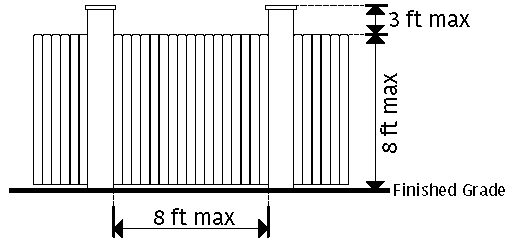
6.9.1.4 Column and ornament heights are permitted to exceed the maximum height by no more than 3 feet.
6.9.2 Placement
6.9.2.1 Fence and wall footings must be entirely contained within the property and cannot encroach onto a property line.
6.9.2.2 For walls or fences to be constructed near a property line, a surveyor shall be utilized to establish the property line prior to construction.
6.9.2.3 Fences, walls, hedges and other vegetation must not obstruct the minimum sight distance requirements and must not:
a) Prohibit proper lines of sight for public safety and law enforcement; b) Impede the flow of water; or c) Impair or block the vision of vehicle drivers so as to constitute a safety hazard.
6.9.3 Design Standards
6.9.3.1 Materials
1) General Provisions
i. Fences or walls must be constructed of wood, masonry, stacked stone, stucco, ornamental metal or other durable material approved by the zoning administrator in all zoning districts. Chain-linked or woven-wire fencing is allowed only in side and rear yards (provided they are not parallel to a street), and must be vinyl-coated.
ii. In zoning districts allowing horses and livestock to be kept, a fence made of chain link or other wire materials is exempt from the four (4) foot maximum height requirement and shall not exceed a maximum of five (5) feet in height in a front yard.
iii. Vinyl is prohibited, except that existing vinyl fences may be replaced in kind.
iv. Barbed wire, razor wire and concertina wire are prohibited. Exception: Public and private utility facilities, governmental owned and operated public facilities and agricultural uses in A1, A2, and Homestead Farms in Major-PUD districts.
v. Walls and fences must be constructed with the finished side facing towards the street and adjoining properties, away from the improvement it is meant to screen.
6.9.3.2 Only black, white or earth tones are permitted. Primary and neon colors are prohibited.
6.9.3.3 Any fence that includes electrical equipment requires an electric (building) permit.
6.9.4 Gates
6.9.4.1 Gates must follow all design standards of this section.
6.9.4.2 Gates may be up to 3 feet taller in height than the fence or wall it is attached to.
6.9.4.3 Public streets cannot be gated.
6.9.4.4 Vehicular Gate Emergency Access:
1) Emergency access through vehicular gates for driveways leading to a dwelling, gated facility, or community shall be in accordance with the following requirements.
2) To allow for the passage of emergency vehicles, any vehicular gate shall have a minimum clearance of 14 feet in width for one-way traffic or driveways and 20 feet in width for two-way traffic. Clearance height through the gate shall maintain 14 feet clearance.
3) Prior to the installation or replacement of a security gate or barrier, the developer or owner shall obtain a security gate or barrier permit. A permit shall only be issued for a security gate or barrier meeting the requirements of this section.
4) Gates must be located a minimum of 30 feet from the adjacent edge of pavement of the road servicing the gate.
5) Prior to any changes, alterations or blocking of private streets or driveways leading to a dwelling, plans detailing the change accompanied by drawings, shall be submitted for approval. A county building inspector shall inspect all such installations.
6) All security gates or barriers shall be equipped with a siren or radio operated receiver/controller capable of receiving signals from a sheriff’s department, fire department, and emergency responders’ siren or radio transceivers that allow emergency responders and other necessary on-duty employees to open the security gate or barrier by use of the equipment.
7) The equipment shall be furnished, installed and maintained by the entity that is served by the equipment.
8) The maintenance and upkeep of any security gate or barrier shall be the sole responsibility of the developer, owner or any duly incorporated and active association having jurisdiction of the gate.
9) Inoperative security gates or barriers shall be repaired immediately. Inoperative gates shall be locked in the open position until repairs are made. Abandoned gates shall be permanently locked in the open position.
10) The party or parties controlling the operation and maintenance of the security gate or barrier shall be liable for any damages caused by the improper operation of the security gate or barrier.
6.9.5 Maintenance
6.9.5.1 Fences shall be maintained in good condition and be structurally sound at all times. No advertising will be permitted thereon.
6.9.5.2 Property located between the fence and any property lines shall also be regularly maintained.
Sec 7.2 A2 Agricultural--Residential District
Sec 7.3 B1 Neighborhood Convenience Commercial District
Sec 7.4 B2 General Commercial Highway Oriented District
Sec 7.5 C3 Heavy Commercial District
Sec 7.6 LI Light Industrial District
Sec 7.7 H-I Heavy Industrial District
Sec 7.8 OI Office-Institutional District
Sec 7.9 PUD Planned Unit Development
Sec 7.10 CPUD Commercial Planned Unit Development District
Sec 7.11 R1 Low-Density Residential District
Sec 7.12 R2 Medium-Density Residential District
Sec 7.13 RM Multi-Family Residential District
Sec 7.14 LR1 Lakeshore Single-Family Residential/Recreation District
Sec 7.15 LR2 Lakeshore Multi-Family Residential/Recreation District
Sec 7.16 LC Lakeshore Commercial District
Sec 7.17 LP Lakeshore Park District
Sec 7.18 AP Airport Corridor District
Sec 7.19 Short-Term Rental Overlay District
This zoning district is comprised primarily of open farm land and land used for intensive agriculture and livestock and poultry production. The intent of the regulations is to encourage the maintenance of the general rural character of openness and discourage the subdivision of land that is better suited to agricultural usage. Major subdivisions with lots of less than 10 acres each are prohibited in this district. A farm or farming operation shall not be found to be a public or private nuisance if the farm or farm operation alleged to be a nuisance conforms to generally accepted agriculture and management practices. The intent of this ordinance is to prevent the non-agricultural resident from encroaching on existing, approved, or projected expansion of farms or farming operations.
7.1.1 Permitted uses. Within the A1 District, only the following uses are permitted:
7.1.1.1 Dwelling, Single- or two-family detached.
7.1.1.2 Individual mobile or manufactured home.
7.1.1.3 Industrialized building qualifying as dwelling, single family detached.
7.1.1.4 Caretaker dwelling for farm workers when located on the same lot as the principal residence of the owner of the agricultural operation, provided that such lot is at least five (5) acres in addition to the minimum lot area required for the principal residence, and subject to all the minimum space requirements of the A1 District.
7.1.1.5 Accessory buildings and uses incidental to the operation of the farm, including private garages, sheds, barns or other storage structures provided said structures are located on the same lot and are not used for conducting a business or service inconsistent with A1 allowed practice and provided that requirements under §§ 9.2.1.5 and 9.6 are met.
7.1.1.6 Agricultural, forestry, livestock, general farming, hog or poultry production excluding operations that qualify as a Confined Animal Feeding Operation. Confined Animal Feeding Operations are specifically excluded as a permitted use in A1 Agricultural District.
7.1.1.7 Daycare home.
7.1.1.8 Sale of agricultural products grown or processed on the premises, provided that adequate pull off lanes and parking are provided at the site, and the use does not adversely affect existing or future adjacent residential uses or seriously impede traffic in the area.
7.1.1.9 Any agriculturally oriented business, including, but not limited to, the sale and repair of farm implements, feed and seed wholesale and retail stores and warehouses and feed and seed storage bins.
7.1.1.10 Automobile service stations provided the requirements of § 9.8 are met.
7.1.1.11 Produce markets and farmers' markets.
7.1.1.12 Swimming pools, above and below ground, provided the pool location, including the pool deck and accessory equipment, is not closer than twenty (20) feet to any adjacent residential lot; the pool location can be adjacent to the Lake Oconee Georgia Power property line for lakeshore property; the pool is enclosed by a wall or fence to the extent required by State Law.
7.1.1.13 Home office.
7.1.1.14 Minor and Major Utility facilities.
7.1.1.15 Signs, provided that requirements of Article X are met.
7.1.1.16 Special Events provided that the parcel where the special event is to be located is at least twenty-five acres in size, and provided that no more than two special events may be held per calendar year per parcel or per property owner on adjoining parcels.
7.1.1.17 Rural home occupation, provided that requirements of § 9.7.2 are met.
7.1.1.18 Borrow Pits less than or equal to 2 acres.
7.1.1.19 Feed lots, provided that requirements of Article III Animal Units are met.
7.1.1.20 Temporary or permanent power for agricultural wells and permanent accessory structures, provided the requirements of 9.2.1.5 and 9.6 are met for accessory structures.
7.1.1.21 Animal units as allowed in section 9.26.
7.1.2 Conditional uses. Within the A1 District, the following uses may be permitted as Conditional Use pursuant to Article XI. Conditional Use applications may be approved or denied as submitted or may be approved subject to specified conditions in addition to those described herein.
7.1.2.1 Religious institutions, provided such uses are located on a lot with a minimum of two (2) acres and fronts on a public right-of-way or a private street which connects with a public right-of-way. The minimum building front setback is 50 feet. A ten (10) foot wide buffer area is required along any property line abutting residentially zoned property.
7.1.2.2 Permanent and temporary sawmills and planning mills, provided that the mill and storage areas are not located closer than 400 feet to a property line.
7.1.2.3 Towers provided the requirements of the Greene County Tower Ordinance is met.
7.1.2.4 Veterinary hospitals, clinics, and kennels, provided no enclosed structure for the keeping of animals is located within 200 feet of a property line.
7.1.2.5 Solid waste landfill provided the requirements of § 9.9 are met.
7.1.2.6 Home occupation, rural, and home occupation, residential.
7.1.2.7 Transfer Stations provided the entire outdoor storage area is properly screened as required in 6.7.
7.1.2.8 Private cemeteries.
7.1.2.9 Recreational developments, including, but not limited to, public fishing lakes, public swimming pools, and golf courses or driving ranges, provided a comprehensive plan for the area is submitted which includes the location of the site on plats of not less than a 1" = 400' scale, the location and function of all buildings and modifications of the natural landscape, the location and surface treatment of all roadways, appropriate details of drinking water or sanitary facilities, certificated by the Health Department if wells or septic tanks are involved and a time schedule setting for a development program.
7.1.2.10 Family Restaurants provided the requirements of § 6.2 are met.
7.1.2.11 Borrow Pits greater than 2 acres.
7.1.2.12 Development of natural resources, including the removal of minerals and natural materials together with necessary buildings and machinery - this includes dredging, mining and mineral exploration.
7.1.2.13 Confined Animal Feeding Operations provided the requirements of § 7.1.4 are met.
7.1.2.14 Solar Farm provided the requirements of Section 9.22 are met.
7.1.3 O.C.G.A. 44-1-17.
7.1.3.1 Prior to any purchase, lease, or other acquisition of real property or any interest in real property located within any county which has land zoned for agricultural or silvicultural use or identified on an approved county land use plan as agricultural or silvicultural use, it shall be the buyer's or grantee's responsibility to determine whether the subject property is within, partially within, or adjacent to any property zoned or identified on an approved county land use plan as agricultural or silvicultural use, the owner or agent for the owner shall deliver to the prospective purchaser, lessee, or grantee a notice which states the following:
"It is the policy of this state and this community to conserve, protect, and encourage the development and improvement of farm and forest land for the production of food, fiver, and other products, and also for its natural and environmental value. This notice is to inform prospective property owners or other persons or entities leasing or acquiring an interest in real property that the property in which they are about to acquire an interest lies within, partially within, or adjacent to an area zoned, used, or identified for farm and forest activities and that farm and forest activities occur in the area. Such farm and forest activities may include intensive operations that cause discomfort and inconveniences that involve, but are not limited to, noises, odors, fumes, dust, smoke, insects, operations of machinery during any 24 hour period, storage and disposal of manure, and the application by spraying or otherwise of chemical fertilizers, soil amendments, herbicides, and pesticides. One of more of these inconveniences may occur as the result of farm or forest activities which are in conformance with existing laws and regulations and accepted customs and standards."
Noncompliance with any provision of this Code section shall not affect title to real property nor prevent the recording of any document.
This Code section shall not apply to any transaction involving title passing by foreclosure, deed in lieu of foreclosure, tax deed, deed to secure debt, or from an executor or administrator.
This Code section shall not create a cause of action for damages or equitable relief.
7.1.4 Standards for confined animal feeding operations.
7.1.4.1 Purpose. The Greene County Board of Commissioners finds that residents in Greene County rely on water resources for drinking water supply, agricultural production, recreation, aesthetic enjoyment, and other activities; and that regulation of land uses within the County is essential for the protection of these water resources from degradation. Greene County residents also rely on an environment that has minimal impacts related to nuisances. The uses of land for Confined Animal Feeding Operations may result in odors, dust, noise, or other effects that may not be compatible with other zoning districts and surrounding areas. Confined Animal Feeding Operations shall be conducted in compliance with all applicable county, state, and federal laws and regulations, including land use, water quality, health, and environmental standards.
7.1.4.2 Additional application submittal requirements. In addition to the standard application for Conditional Use, the following requirements shall be met and the following additional information shall be submitted with a Conditional Use application:
- Application fee. An additional permit application fee of $0.05 per animal based on the capacity of the proposed operation.
- Development and design plan. A comprehensive, detailed site plan showing and identifying significant onsite and proposed features, to include:
- The boundaries of the parcel of land by survey.
- Any existing and proposed structures on the property.
- Any water impoundments and/or waterways on the property.
- Any existing and proposed wells.
- Any existing and proposed septic systems.
- Any existing and proposed screening.
- Any public roadways directly serving the parcel of land.
- Required setbacks.
- Required buffer zone.
- Any existing and proposed utility lines.
- Existing and proposed topographic contours at vertical intervals of five feet maximum (U.S.G.S topographic maps may be used for existing contours).
7.1.4.3 Additional requirements, review criteria, and development and design standards.
7.1.4.3.1 Buffer zone. Confined Animal Feeding Operations shall be located to reduce impacts from nuisances to the greatest extent practicable. A Buffer Zone must be located on the outer perimeter of the confinement area, with appropriate fencing, landscaping or other barrier as shall be approved by the County as a condition of Conditional Use approval. A Buffer Zone shall not be located on any portion of any existing or dedicated public or private street right-of-way and shall be privately owned and maintained. A Buffer Zone is a unit of required space and plantings and/or structures designed to reduce conflicts between adjacent land uses by eliminating or minimizing potential nuisances such as light, odor, noise, pests, dust, or unsightly buildings.
7.1.4.3.2 Odors. Confined Animal Feeding Operations shall be operated in compliance with all state and federal laws, rules and regulations and in such a manner as to not constitute a nuisance as defined by law.
7.1.4.3.3 Character of the neighborhood and surrounding community. The use, as determined in the sole discretion of the Board of Commissioners, must be compatible with the character of the surrounding neighborhood and must not have negative impacts on adjacent properties. The determination of compatibility shall be based upon a consideration of the level of traffic; hours of operation; scale and design of buildings; noise, odor or vibration; and similar impacts associated with the proposed land use.
7.1.4.3.4 Traffic. The use must not cause undue traffic, congestion, dangerous traffic conditions, or other vehicle-related impacts. The Board of Commissioners shall have sole discretion in determining if the proposed Confined Animal Feeding Operation will cause excessive traffic that is incompatible, and/or detrimental to the immediately surrounding areas.
7.1.4.3.5 Nuisance. Subject to the protections of O.C.G.A. § 41-1-7, the operating characteristics of the use shall not create a nuisance and the impacts on neighboring property shall be minimized with respect to noise, odors, vibrations, glare and similar conditions.
7.1.4.3.6 Setbacks. The specific setback requirements for Confined Animal Feeding Operations set forth herein are intended to minimize the adverse effects commonly associated with such operations, provided that larger setbacks or other conditions may be imposed as conditions so as to minimize adverse effects on surrounding property in cases involving, but not limited to, uncommonly large operations, unusual topographical conditions, or proximity to sensitive natural, scenic, or historic areas, municipal boundaries, and residential areas.
- No Confined Animal Feeding Operation shall be constructed in any location where any portion of the Confinement Area is 500 feet or less from the property boundaries of the parcel on which the Confinement Area is to be constructed.
- No Confined Animal Feeding Operation shall be constructed in any location where any portion of the Confinement Area is 1,500 feet or less from any building or property that is regularly used as a school, hospital, church, a public park, a public recreational area, a senior center, a nursing home or retirement home, a restaurant, or public community center.
- No Confined Animal Feeding Operation shall be constructed in any location where any portion of the Confinement Area is 200 feet or less from any perennial stream.
7.1.4.3.7 Air quality protection. The operation of Confined Animal Feeding Operation facilities shall not exceed allowable emissions of substances or compounds regulated by state or federal Clean Air Acts, or the Clean Air Act Amendments of 1990, or any future amendments to either, or any other applicable statute or regulation.
7.1.4.3.8 Dead animal disposal. Dead animals shall be disposed of in a way that does not adversely affect ground or surface water and does not compromise public health. Any dead animal shall be disposed of within seventy-two (72) hours of discovery by removal for rendering, cremation, burial or composting as approved by the Georgia Department of Agriculture and by the Environmental Protection Division of the Georgia Department of Natural Resources.
7.1.4.4 Nonconforming uses. Existing Confined Animal Feeding Operations which were in operation at the time the Zoning Ordinance of Greene County, Georgia (hereinafter "Ordinance") was amended to include § 7.1.4, and which do not meet the requirements as described in this § 7.1.4, shall be grandfathered as existing nonconforming uses for purposes of the Ordinance. If such legally nonconforming operations contain less than six (6) Confinement Areas, the grandfathered operation may, as a Permitted Use, construct additional Confinement Areas without compliance with § 7.1.4, provided that the total number of Confinement Areas does not exceed six (6) and, if a poultry operation, the total number of animals associated with the poultry operation does not exceed 250,000 at any given time.
(Ord. of 12-8-2020, § 1(Exh. A))
Amended by Res. 2023.7.11(a) 7.1.1.16 Special Events amended on 7/11/2023
Repealed & Replaced by Res. 2024.10.8(a) 7.1.1.16 Special Event only on 10/8/2024
Repealed by Res. 2024.10.8(a) repealed and renumbered on 10/8/2024
This zoning district is composed primarily of limited agricultural activities in areas where compatible low density, rural, single-family residential development has occurred or is occurring. The regulations for this district are designed to provide the landowner an opportunity to engage in limited hobby type agricultural activities for personal use, with sold to the public. A farm or farming operation shall not be found to be a public or private nuisance if the farm or farm operation alleged to be a nuisance conforms to generally accepted agriculture and management practices. The intent of this ordinance is to prevent the non-agricultural resident from encroaching on existing, approved, or projected expansion of farms or farming operations.
7.2.1 Permitted uses. Within the A2 District, the following uses are permitted:
7.2.1.1 Dwelling, Single- or two-family detached.
7.2.1.2 Individual manufactured home.
7.2.1.3 Industrialized building qualifying as Dwelling, Single- or two-family detached.
7.2.1.4 Accessory buildings and accessory uses provided the requirements of § 9.6 are met.
7.2.1.5 Agricultural uses including small scale crop farming, gardening, forestry, but excluding confined animal feeding operations and feedlots.
7.2.1.6 Raising or keeping animals and fowl not sold for slaughter, not to exceed the requirements specified in Article III, Animal Units.
7.2.1.7 Daycare home.
7.2.1.8 Swimming pools, above and below ground, provided the pool location, including the pool deck and accessory equipment, is not closer than twenty (20) feet to any adjacent residential lot; the pool location can be adjacent to the Lake Oconee Georgia Power property line for lakeshore property; the pool is enclosed by a wall or fence to the extent required by State Law. Only home swimming pools and private community swimming pools are permitted.
7.2.1.9 Nurseries, for the production and sale of plants and their related products.
7.2.1.10 Sale of agricultural products grown or processed on the premises owned by the seller, provided that adequate pull off lanes and parking are provided at the site, and the use does not adversely affect existing or future adjacent residential uses or seriously impede traffic in the area.
7.2.1.11 Minor and Major Utility facilities.
7.2.1.12 Signs, provided that requirements of Article X are met.
7.2.1.13 Special Events provided that the parcel where the special event is to be located is at least twenty-five acres in size, and provided that no more than two special events may be held per calendar year per parcel or per property owner on adjoining parcels.
7.2.1.14 Rural home occupation, provided that requirements of § 9.7.2 are met.
7.2.1.15 Residential home occupation, provided that requirements of 9.7 are met.
7.2.1.16 Borrow Pits less than or equal to 2 acres.
7.2.1.17 Temporary or permanent power for agricultural wells and permanent accessory structures, provided the requirements of 9.2.1.5 and 9.6 are met for accessory structures.
7.2.1.18 Animal units as allowed in section 9.26.
7.2.2 Conditional uses. Within the A2 District, the following uses may be permitted with Conditional Use approval pursuant to Article XI. Conditional Use applications may be approved or denied as submitted or may be approved subject to specified conditions in addition to those described herein.
7.2.2.1 Cemeteries.
7.2.2.2 Community center or club, provided that the requirements of § 9.13 are met and further provided such uses are located on a lot with a minimum of two (2) acres and fronts on a public right-of-way or a private street which connects with a public right-of-way. The minimum building front setback is fifty (50) feet. A ten (10) ft. wide buffer area is required along any property line abutting residentially zoned property.
7.2.2.3 Public and private schools provided that a complete site development sketch is submitted with the application. The school must be located on a lot fronting an arterial or collector street. All buildings must be at least fifty (50) feet from any property line. The property must be on a lot of a minimum of two (2) acres and must be bordered by a ten (10) foot wide buffer area along its exterior boundary lines that do not border the frontage street. The buffer must not extend into the required front yard. The buffer area should be planted with evergreen trees or shrubs that grow at least eight (8) feet tall within three (3) years and provide an effective visual screen.
7.2.2.4 Recreational developments, including, but not limited to, public fishing lakes, public swimming pools. and golf courses or driving ranges, provided a comprehensive plan for the area is submitted which includes the location of the site on plats of not less than a 1" = 400' scale, the location and function of all buildings and modifications of the natural landscape, the location and surface treatment of all roadways, appropriate details of drinking water or sanitary facilities, certificated by the Health Department if wells or septic tanks are involved and a time schedule setting for a development program.
7.2.2.5 Religious institutions, provided such uses are located on a lot with a minimum of two (2) acres and fronts on a public right-of-way or a private street which connects with a public right-of-way. The minimum building front setback is fifty (50) feet. A ten (10) ft. wide buffer area is required along any property line abutting residentially zoned property.
7.2.2.6 Family Restaurants provided the requirements of § 6.2 are met.
7.2.2.7 Borrow Pits greater than 2 acres.
7.2.3 O.C.G.A. 44-1-17. The provisions of § 7.1.3 shall apply in the A2 district.
(Ord. of 12-8-2020, § 1(Exh. A))
Amended by Res. 2023.7.11(a) 7.2.1.13 Special Events amended on 7/11/2023
Repealed & Replaced by Res. 2024.10.8(a) 7.2.1.13 Special Events only on 10/8/2024
Repealed by Res. 2024.10.8(a) repealed and renumbered on 10/8/2024
This zoning district is intended for the development of small clusters of retail sales and service establishments which when appropriately located are designed to provide limited convenience shopping and services primarily for surrounding residential areas.
7.3.1 Permitted uses. Within the B1 District, only the following uses are permitted:
7.3.1.1 Accessory buildings and accessory uses provided the requirements of § 9.6 are met.
7.3.1.2 Arts and Crafts store.
7.3.1.3 Automobile service stations provided the requirements of § 9.8 are met.
7.3.1.4 Automobile repair garage when in conjunction with an automobile service station.
7.3.1.5 Bakery.
7.3.1.6 Barber and beauty shop.
7.3.1.7 Book, Stationary and Card Shop.
7.3.1.8 Business office.
7.3.1.9 Cafes and grills.
7.3.1.10 Clothing alteration.
7.3.1.11 Coffee shop
7.3.1.12 Convenience store.
7.3.1.13 Daycare center.
7.3.1.14 Drug store.
7.3.1.15 Dry cleaners.
7.3.1.16 Financial institution.
7.3.1.17 Florist, nursery and gift shop.
7.3.1.18 Frame shop.
7.3.1.19 Grocery store.
7.3.1.20 Hardware store.
7.3.1.21 Indoor self-service laundry.
7.3.1.22 Nurseries, for the production and sale of plants and their related products.
7.3.1.23 Professional office.
7.3.1.24 Minor and Major Utility facilities.
7.3.1.25 Restaurant.
7.3.1.26 Shopping centers with uses as otherwise permitted in the B1 District and a total leasable floor area of less than seventy-five thousand (75,000) square feet.
7.3.1.27 Signs, provided the requirements of Article X are met.
7.3.1.28 Special Events provided that the parcel where the special event is to be located is at least twenty-five acres in size, and provided that no more than two special events may be held per calendar year per parcel or per property owner on adjoining parcels.
7.3.1.29 Veterinary hospitals, clinics and kennels, provided no unenclosed structure for the keeping of animals is located within two hundred (200) feet of a property boundary.
7.3.1.30 Borrow Pits less than or equal to 2 acres.
7.3.2 Conditional uses. Within the B1 Neighborhood Convenience Commercial District, the uses enumerated below may be permitted with Conditional Use approval pursuant to Article XI. Conditional Use applications may be approved or denied as submitted or may be approved subject to specified conditions in addition to those described herein.
7.3.2.1 Nursing homes.
7.3.2.2 Second floor of a commercial use may be used as a residential dwelling unit provided it is served by a separate private entrance and exit.
7.3.2.3 Congregate Personal Care Home.
7.3.2.4 Self-storage facility incorporated with outdoor storage of recreational vehicles provided the entire outdoor storage area is properly screened as required in 6.7.
7.3.2.5 Automobile laundry or car wash provided that the paved area for the vehicle awaiting entrance to the washing process is located on the same lot. The paved area must be of sufficient size to adequately contain the number of vehicles (at two hundred (200) square feet per vehicle) equal to one-third of the practical hourly capacity of the washing machines. Curb breaks are limited to two (2), each not to exceed thirty (30) feet in width, and located no closer than fifty (50) feet to an intersection.
7.3.2.6 Restaurant, fast-food.
(Ord. of 12-8-2020, § 1(Exh. A))
Amended by Res. 2023.7.11(a) 7.3.1.28 Special Events amended on 7/11/2023
Repealed & Replaced by Res. 2024.10.8(a) 7.3.1.28 Special Events only on 10/8/2024
Amended by Ord. 2025-02-11 Zoning changes on 2/11/2025
The B-2 General Commercial Highway Oriented District is intended for denser commercial development that may extend along highways and provide services to both highway oriented and municipality-oriented trade. All businesses, services, storage or processing shall be conducted within an enclosed building, except where the nature of the activity makes it impossible (i.e., off-street loading, automobile parking for customers while on the premises, and the sale of automobile fuel at service stations). Use, processes or equipment employed on the premises shall be limited to those which are not objectionable by reason of odor, dust, bright lights, smoke, noise, or vibration.
7.4.1 Permitted uses. Within the B2 District, only the following uses are permitted:
7.4.1.1 Accessory buildings and accessory uses provided the requirements of § 9.6 are met.
7.4.1.2 Ambulance Service.
7.4.1.3 Apparel stores.
7.4.1.4 Appliance store including radio and television service.
7.4.1.5 Arts and Crafts stores.
7.4.1.6 Automobile repair garage, mechanical and body shops.
7.4.1.7 Automobile and boat service stations provided the requirements of § 9.8 are met.
7.4.1.8 Automobile repair garage when in conjunction with an automobile service station.
7.4.1.9 Bakeries.
7.4.1.10 Barber and beauty shop.
7.4.1.11 Bicycle or motorcycle store.
7.4.1.12 Books, stationary and card shops.
7.4.1.13 Bowling alleys.
7.4.1.14 Cafes, grills, and lunch counters.
7.4.1.15 Camera or photographic supply store.
7.4.1.16 Catering establishments.
7.4.1.17 Clothing, shoe, dry goods or gift store.
7.4.1.18 Coffee shop.
7.4.1.19 Commercial parking garage or lot provided no entrance or exit is on the same block as a school, and curb breaks are limited to two (2) for each one hundred (100) feet of street frontage, each not to exceed thirty (30) feet in width and at least fifty (50) feet separation and not located closer than fifty (50) feet to a street intersection.
7.4.1.20 Computer sales and services.
7.4.1.21 Confectionery store.
7.4.1.22 Convenience store.
7.4.1.23 Daycare center.
7.4.1.24 Dressmaking and tailoring shops.
7.4.1.25 Drug store.
7.4.1.26 Dry cleaning and laundry establishments.
7.4.1.27 Electronic supply store.
7.4.1.28 Fabric store.
7.4.1.29 Financial institution.
7.4.1.30 Florist, nursery and gift shop.
7.4.1.31 Frame shop.
7.4.1.32 Funeral home.
7.4.1.33 Furniture, home furnishings, including office furniture and equipment.
7.4.1.34 Grocery, fruit, vegetable, meat market, delicatessen, catering, supermarkets, and packaged alcoholic beverages stores.
7.4.1.35 Hardware store.
7.4.1.36 Health Club.
7.4.1.37 Indoor laundromat.
7.4.1.38 Jewelry store.
7.4.1.39 Laundry and dry cleaning pick-up stations, and indoor self-service laundry.
7.4.1.40 Laundry and dry cleaning store.
7.4.1.41 Lawn and Garden Shop.
7.4.1.42 Medical clinic.
7.4.1.43 Miniature golf course.
7.4.1.44 Miscellaneous repair service.
7.4.1.45 Motels, hotels.
7.4.1.46 News and tobacco center.
7.4.1.47 Nurseries, for the production and sale of plants and their related products.
7.4.1.48 Nursing home.
7.4.1.49 Paint store.
7.4.1.50 Professional and business office.
7.4.1.51 Printing, blue printing, book binding, photo stating, lithography and publishing establishments.
7.4.1.52 Produce and farmers markets.
7.4.1.53 Restaurants.
7.4.1.54 Restaurants, drive-in.
7.4.1.55 Restaurants, fast food.
7.4.1.56 Shopping centers with uses as otherwise permitted in the B2 District and a total leasable floor area of more than seventy-five thousand (75,000) square feet.
7.4.1.57 Signs, provided the requirements of Article X are met.
7.4.1.58 Special Events provided that the parcel where the special event is to be located is at least twenty-five acres in size, and provided that no more than two special events may be held per calendar year per parcel or per property owner on adjoining parcels.
7.4.1.59 Sporting Goods store.
7.4.1.60 Temporary commercial use, including the sale of Christmas trees or the sale of seasonal fruit, but not to exceed a period of two consecutive months in a calendar year.
7.4.1.61 Theater.
7.4.1.62 Travel agency.
7.4.1.63 Minor and Major Utility facilities.
7.4.1.64 Veterinary hospitals and animal shelters, provided adequate opaque screening by a wall or fence at least six (6) feet high is provided for areas where horses, dogs and other animals are not kept in cages or stalls.
7.4.1.65 Borrow Pits less than or equal to 2 acres.
7.4.2 Conditional uses. Within the B2 General Commercial Highway Oriented District, the uses enumerated below may be permitted with Conditional Use approval pursuant to Article XI. Conditional Use applications may be approved or denied as submitted or may be approved subject to specified conditions in addition to those described herein.
7.4.2.1 Second floor of a commercial use may be used as a residential dwelling unit provided it is served by a separate private entrance and exit.
7.4.2.2 Boat Sales provided the following:
- The exterior lot for the proposed use shall be adequate in size and shape to accommodate the storage of twenty-five (25) large boats and all required setbacks, fencing, landscaping, parking, and other elements necessary and appropriate for the use.
- Any outdoor storage yard must be located only in the rear and completely surrounded by a solid 8 foot tall fence such that stored items are not visible from outside the fencing.
- A landscape design plan must be submitted with the Conditional Use Application that includes elements to provide additional screening to the storage yard in order to soften the appearance of the fence described in subsection (b), above.
- Boats offered for sale may only be located inside the showroom or the rear storage yard, except that during the hours the boat sales business is open for sales, for a maximum of nine (9) hours in any twenty-four (24) hour period, a maximum of four (4) boats may be located on the outside area of the lot provided that the boats are placed on industry appropriate dollies or staging devices other than boat trailers or forklifts, and that any such boat is removed from the outside area prior to close of business each day.
- No boats, trailers, or other inventory of the business shall be parked on public or private streets.
- No paid long-term storage is permissible. Any storage must be limited to active service units, in-queue service units, and boat sales inventory.
- Violations of any provision of the Conditional Use approval shall be subject to penalties in accordance with Article XII, Sec. 12.5.
7.4.2.3 Automobile laundry or car wash provided that the paved area for the vehicle awaiting entrance to the washing process is located on the same lot. The paved area must be of sufficient size to adequately contain the number of vehicles (at two hundred (200) square feet per vehicle) equal to one-third of the practical hourly capacity of the washing machines. Curb breaks are limited to two (2), each not to exceed thirty (30) feet in width, and located no closer than fifty (50) feet to an intersection.
7.4.2.4 Community Center or club provided the requirements of § 9.13 are met.
7.4.2.5 Religious Institution.
7.4.2.6 Motels, provided at least ten (10) rooms for overnight occupancy are available.
7.4.2.7 Self-storage facility incorporated with outdoor storage of recreational vehicles provided the entire outdoor storage area is properly screened as required in 6.7.
(Ord. of 12-8-2020, § 1(Exh. A))
Amended by Res. 2022.9.13(b) on 9/13/2022
Repealed & Replaced by Res. 2024.10.8(a) 7.4.1.58 Special Events only on 10/8/2024
The C3 District is established to protect and promote a suitable environment for those retail uses that generate loud noises, excessive traffic, or require large areas for outdoor storage. Included among these uses are establishments of a commercial-industrial nature, as well as those of a commercial-recreational nature. This area provides for substantial motor vehicle traffic.
7.5.1 Permitted uses. Within the C-3 District, only the following uses are permitted.
7.5.1.1 Accessory buildings and accessory uses provided the requirements under § 9.6 are met.
7.5.1.2 Auction houses.
7.5.1.3 Reserved.
7.5.1.4 Automobile service station provided the requirements of § 9.8 are met.
7.5.1.5 Automobile repair garage.
7.5.1.6 Automobile and truck rental.
7.5.1.7 Automobile sales lot.
7.5.1.8 Automobile laundry or car wash provided that the paved area for the vehicle awaiting entrance to the washing process is located on the same lot. The paved area must be of sufficient size to adequately contain the number of vehicles (at two hundred (200) square feet per vehicle) equal to one-third of the practical hourly capacity of the washing machines. Curb breaks are limited to two (2), each not to exceed thirty (30) feet in width, and located no closer than fifty (50) feet to an intersection.
7.5.1.9 Building and lumber supply establishments provided the entire storage area is properly screened as required in § 6.7.
7.5.1.10 Bus and Railroad terminal facilities.
7.5.1.11 Coffee shop.
7.5.1.12 Commercial parking garage or lot provided no entrance or exit be on the same block as a school, and that curb breaks be limited to two (2) for each one hundred (100) feet of street frontage, each not to exceed thirty (30) feet in width and at least fifty (50) feet separation and not located closer than fifty (50) feet to a street intersection.
7.5.1.13 Farm equipment sales.
7.5.1.14 Flea market.
7.5.1.15 Hospital.
7.5.1.16 Manufactured Homes sales lot.
7.5.1.17 Nurseries, for the production and sale of plants and their related products.
7.5.1.18 Restaurant.
7.5.1.19 Restaurant, drive-in.
7.5.1.20 Restaurant, fast food.
7.5.1.21 Self-storage facility including with outdoor storage of recreational vehicles provided the entire outdoor storage area is properly screened as required in 6.7.
7.5.1.22 Shopping Center.
7.5.1.23 Signs, provided the requirements of Article X are met.
7.5.1.24 Special Events provided that the parcel where the special event is to be located is at least twenty-five acres in size, and provided that no more than two special events may be held per calendar year per parcel or per property owner on adjoining parcels.
7.5.1.25 Tower provided the requirements of § 9.17 are met.
7.5.1.26 Trucking and Motor Freight companies.
7.5.1.27 Minor and Major Utility facilities.
7.5.1.28 Warehousing.
7.5.1.29 Wholesale outlets.
7.5.1.30 Borrow Pits less than or equal to 2 acres.
7.5.1.31 Tow truck and wrecker services.
7.5.2 Conditional uses. Within the C-3 Heavy Commercial District, the uses enumerated below may be permitted with Conditional Use approval pursuant to Article XI. Conditional Use applications may be approved or denied as submitted or may be approved subject to specified conditions in addition to those described herein.
7.5.2.1 Amusement parks.
7.5.2.2 Borrow Pits greater than 2 acres.
(Ord. of 12-8-2020, § 1(Exh. A))
The LI zone is established to protect and promote a suitable environment for light industrial purposes, including accessibility to major transportation facilities, and availability of adequate utilities and other public services. Industrial uses that cause obnoxious noise, vibrations, smoke, gas, fumes, odor, dust, glare, fire hazards or other objectionable environment conditions are prohibited from this district.
7.6.1 Permitted uses. Within the LI District, only the following uses are permitted.
7.6.1.1 Accessory buildings and accessory uses provided the requirements under § 9.6 are met.
7.6.1.2 Any establishment for manufacture, repair, assembly or processing totaling less than 500,000 square feet in floor area, and employing less than 200 employees, including, but not restricted to the following:
- Confectionery manufacture;
- Clothing and garment manufacture;
- Laboratories for testing materials, chemical analysis, photography procession;
- Manufacturing and assembly of scientific, optical and electrical equipment.
- Manufacture of musical instruments and parts.
- Manufacture of souvenirs and novelties.
- Manufacture of toys, sporting and athletic goods.
7.6.1.3 Baking and food processing plants, fish and poultry houses, but not including the on-site slaughter or processing of animals.
7.6.1.4 Cold storage plants.
7.6.1.5 Public airport.
7.6.1.6 Permanent sawmills and planing mills.
7.6.1.7 Contractor's storage and equipment yards when located entirely within a building or fenced area as required by § 6.7.
7.6.1.8 Dyeing plants.
7.6.1.9 (Reserved.)
7.6.1.10 Frozen dessert and milk processing plants.
7.6.1.11 Industrial Parks and Planned Industrial Parks, provided that the provisions of § 9.10 are met.
7.6.1.12 Printing and publishing plants.
7.6.1.13 Processing of raw or semi-finished materials.
7.6.1.14 Minor and Major Utility facilities.
7.6.1.15 Radio stations.
7.6.1.16 Retail sales of goods or products produced or processed on the site, provided sufficient paved off-street parking and loading space is constructed to accommodate retail customers.
7.6.1.17 Signs, provided the requirements of Article X are met.
7.6.1.18 Towers provided the requirements of § 9.17 are met.
7.6.1.19 Borrow Pits less than or equal to 2 acres.
7.6.1.20 Manufactured home sales.
7.6.2 Conditional uses. Within the Light Industrial District, the uses enumerated below may be permitted with Conditional Use approval pursuant to Article XI. Conditional Use applications may be approved or denied as submitted or may be approved subject to specified conditions in addition to those described herein.
7.6.2.1 Truck terminals, provided that acceleration and deceleration lanes of at least two hundred (200) feet, including 50 feet flare, are provided for trucks entering or leaving the site and that generated truck traffic will not create safety hazard or unduly impede traffic.
7.6.2.2 Crematorium.
7.6.2.3 Transfer Stations provided the entire outdoor storage area is properly screened as required in 6.7.
7.6.2.4 Borrow Pits greater than 2 acres.
7.6.2.5 Automobile laundry or car wash provided that the paved area for the vehicle awaiting entrance to the washing process is located on the same lot. The paved area must be of sufficient size to adequately contain the number of vehicles (at two hundred (200) square feet per vehicle) equal to one-third of the practical hourly capacity of the washing machines. Curb breaks are limited to two (2), each not to exceed thirty (30) feet in width, and located no closer than fifty (50) feet to an intersection.
(Ord. of 12-8-2020, § 1(Exh. A))
The H-I Heavy Industrial District is established to provide appropriate locations for any use that may be obnoxious or offensive by reason of emission, odors, dust, smoke, gas, noise, vibration or traffic. All residential uses are prohibited in this district.
7.7.1 Permitted uses. Within the H-I District, only the following uses are permitted:
7.7.1.1 Automobile and boat sales provided the entire outdoor storage area is properly screened as required in 6.7.
7.7.1.2 Automobile and boat service provided the entire outdoor storage area is properly screened as required in 6.7.
7.7.1.3 Bottling and canning plants provided the entire outdoor storage area is properly screened as required in 6.7.
7.7.1.4 Borrow pits less than or equal to 2 acres.
7.7.1.5 Ceramic production facilities provided the entire outdoor storage area is properly screened as required in 6.7.
7.7.1.6 Cold storage plants and frozen food lockers.
7.7.1.7 Commercial sales of the product(s) permitted to be manufactured, assembled, or processed, on-site unenclosed or enclosed, not to exceed twenty (20) percent of the lot area.
7.7.1.8 Convenience stores, with or without gasoline pumps.
7.7.1.9 Dry cleaning plants.
7.7.1.10 Dwelling for caretaker or night watchman.
7.7.1.11 Electronics assembly and manufacturing of communications equipment provided the entire outdoor storage area is properly screened as required in 6.7.
7.7.1.12 Exterminating and pest control businesses.
7.7.1.13 Ice manufacturing.
7.7.1.14 Manufactured home sales incorporated with outdoor storage of manufactured homes provided the entire outdoor storage area is properly screened as required in 6.7.
7.7.1.15 Mini-warehouses incorporated with outdoor storage of recreational vehicles provided the entire outdoor storage area is properly screened as required in 6.7.
7.7.1.16 Metal products manufacturing provided the entire outdoor storage area is properly screened as required in 6.7.
7.7.1.17 Pharmaceuticals and medical supplies manufacturers.
7.7.1.18 Printing, blueprinting, publishing, and book binding facilities.
7.7.1.19 Service stations.
7.7.1.20 Sign fabrication and painting shops.
7.7.1.21 Textile manufacturing and processing provided the entire outdoor storage area is properly screened as required in 6.7.
7.7.1.22 Warehouses and storage buildings.
7.7.1.23 Wood products manufacturing provided the entire outdoor storage area is properly screened as required in 6.7.
7.7.1.24 Minor and Major Utility facilities.
7.7.2 Conditional uses. Within the Heavy Industrial District, the uses enumerated below may be permitted with Conditional Use approval pursuant to Article XI. Conditional Use applications may be approved or denied as submitted or may be approved subject to specified conditions in addition to those described herein.
7.7.2.1 Concrete/lime/gypsum/plaster manufacturing facility.
7.7.2.2 Asphalt and Concrete processing facilities.
7.7.2.3 Junkyards.
7.7.2.4 Landfills.
7.7.2.5 Development of natural resources, including the removal of minerals and natural materials together with necessary buildings and machinery - this includes dredging, mining and mineral exploration.
7.7.2.6 Borrow pits greater than 2 acres.
7.7.2.7 Crematorium.
7.7.2.8 Transfer Stations.
7.7.2.9 Commercial sales of the product(s) permitted to be extracted, unenclosed, exceeding twenty (20) percent of the lot area but not exceeding fifty (50) percent of the lot area.
7.7.2.10 Communication towers and communication antennas.
7.7.2.11 Cosmetics and toiletries manufacturers.
7.7.2.12 Feed, grain, and fertilize production.
7.7.2.13 Food processing plants or on-site slaughter facilities, including fish and poultry facilities.
7.7.2.14 Solar Farm provided the requirements of Section 9.22 are met.
7.7.3 Requirements.
7.7.3.1 All operations shall maintain a buffer of a minimum of 500 feet to a residential district and public roads.
7.7.3.2 All such operations, except driveway areas, shall be completely enclosed by an opaque fence, wall, or other opaque screening (including earthen berms and vegetation) having a minimum height of six feet but in no case less than such a height as will effectively screen all operations from view from the property line. Fences must be painted a natural color and maintained in good condition.
7.7.3.3 The number of vehicular driveways permitted on any single street frontage shall be limited to one per 500 feet of frontage with a minimum of 24 feet driveway width.
7.7.3.4 All operations shall conform to the following performance standards:
Performance Standard | Requirements |
Electro-magnetic interference | Electromagnetic interference shall comply with all federal and state laws, rules, and regulations. |
Glare and Heat | Every use and activity shall be so operated that it does not emit heat or heated air beyond the boundary of the lot, as defined in Article III, on which it is located. No direct or sky-reflected glare shall emanate from any use or activity so as to be visible at any point on or beyond the boundary of the lot on which such use or activity is located. |
Noise | All equivalent sound levels at the boundaries of an industrial or mining district shall not exceed: 60 dbA LEQ for projects adjacent to residential or office residential districts or public properties; 65 dBA LEQ for projects adjacent to commercial or office districts; 75 dBA LEQ for projects adjacent to other industrial or mining districts. Method of measurement: Measurements shall be made with a calibrated sound level meter in good operating condition, meeting the requirements of a Type I or Type II meter, as specified in ANSI Standards, Section 1.4 - 1971. For purposes of this section, a sound level meter shall contain at least an "A" weighting network, and both fast and slow response capability. |
Odor | No continuous, frequent, or repetitive emission of odors or odor- causing substances which would be offensive beyond any property line of any industrial or mining district will be permitted. An odor emitted no more than fifteen (15) minutes in any one (1) day shall not be deemed as continuous, frequent, or repetitive. The existence of an odor shall be presumed when analysis by a competent technician demonstrates that a discernible odor is being emitted. Any process which may involve the creation or emission of any odors shall be provided with a primary and a secondary safeguard system so that control will be maintained if the primary safeguard system fails. |
Smoke and particulate matter | Emissions shall not exceed federal and state laws, rules, and regulations. |
Vibration | Ground vibration as measured at the boundary of property located in an industrial or mining zoning district shall not exceed 1.0 inches per second peak velocity, steady state, or 2.0 inches per second, impact state. |
(Ord. of 12-8-2020, § 1(Exh. A))
The OI District is intended to provide an area for business and professional offices as well as for social, fraternal, political, civic and community organization. The district is also designed for institutional uses such as hospitals, nursing homes, convalescent centers, institutional planned developments and clinics. The following uses are permitted:
7.8.1 Permitted uses. Within the OI District, only the following uses are permitted:
7.8.1.1 Accessory building and accessory uses provided the requirements of § 9.6 are met.
7.8.1.2 Art, music, drama, photography, dance, theatrical studies.
7.8.1.3 Community center or club provided the requirements of § 9.13 are met, and further provided such uses are located on a lot with a minimum of 2 acres and front on a public right-of-way or a private street which connects with a public right-of-way. A ten (10) foot wide buffer area is required along any property line abutting residentially zoned districts.
7.8.1.4 Financial institutions, security-commodity brokers and exchanges, and holding and investment companies.
7.8.1.5 Funeral homes.
7.8.1.6 Hospital.
7.8.1.7 Institutional and philanthropic uses.
7.8.1.8 Libraries.
7.8.1.9 Medical and dental offices, clinics, and laboratories.
7.8.1.10 Museum.
7.8.1.11 Nursing homes, group personal care homes, congregate personal care homes, and memory care unit on a minimum lot size of 3 acres with at least 200 feet of width at the building line and at least 200 feet of frontage on a public road.
7.8.1.12 Offices for business, professional, governmental, civic, social, fraternal, political and charitable organizations.
7.8.1.13 Public and private primary and secondary schools, colleges, technical and vocational centers, including pre-schools, kindergartens, day care for children or adults, provided such uses are located on a lot with a minimum of 2 acres and front on a public right-of-way or a private street which connects with a public right-of-way. A ten (10) foot wide buffer area is required along any property line abutting residentially zoned districts.
7.8.1.14 Religious institutions, provided such uses are located on a lot with a minimum of 2 acres and front on a public right-of-way or a private street which connects with a public right-of-way. A ten (10) foot wide buffer area is required along any property line abutting residentially zoned districts.
7.8.1.15 Research, development, and testing laboratories and centers.
7.8.1.16 Minor and Major Utility facilities.
7.8.1.17 Borrow Pits less than or equal to 2 acres.
7.8.2 Conditional uses. Within the Office-Institutional District, the uses enumerated below may be permitted with Conditional Use approval pursuant to Amendment XI. Conditional Use applications may be approved or denied as submitted or may be approved subject to specified conditions in addition to those described herein.
7.8.2.1 Borrow Pits greater than 2 acres.
(Ord. of 12-8-2020, § 1(Exh. A))
7.9.1 The PUD districts establish a mechanism to implement the vision and principles of the Comprehensive Plan and provides for innovative concepts in large-scale residential development that enables economy in capital maintenance, yet does not forsake the desired rural setting of openness and a livable environment. Allied uses, public facilities and enclosed recreational uses are allowed. Through the Planned Unit Development process, it is the intent that property will be developed with a unified design providing continuity between the various elements. However, the PUD process is not intended as a device to circumvent general development regulations, densities, standards and good planning practice.
7.9.2 PUDs on contiguous property may be consolidated as a single PUD. To be eligible for a PUD consolidation, an application must provide documentation showing that the PUDs to be combined are subject to unified control and management. Subsequent to a PUD consolidation, the standards, requirements and restrictions of this Ordinance shall apply to the larger consolidated PUD as a single, unified development. The application for joining of PUDs must document the current land uses and acreages for each PUD, and then document the land uses and acreages for the proposed combined PUD.
7.9.3 Properties that are not zoned PUD may be annexed into a contiguous existing PUD. Any developed property that is annexed into a contiguous PUD shall not be required to comply with the PUD district regulations so long as it was lawfully developed with a use permitted by the PUD regulations at the time of its annexation. Any developed property that is annexed into a Minor PUD that does not already comply with the Minor PUD district regulations shall not be considered towards qualification as a Major PUD.
7.9.4 All submissions of development plans for a PUD must comply with the applicable provisions of § 9.18 and must be served by a central sewerage and a central water system adequately sized to supply fire hydrants at the time of submission. Existing subdivision development extensions are not required to connect to central sewerage or upgrade the central water system to support fire hydrants unless the proposed extension is within 1,500 feet of a point of connection capable of handling said improvements.
7.9.5 Minor Planned Unit Development (PUD)
To qualify as a Minor PUD, the development must be a minimum of 200 contiguous acres, provided, however, that a parcel that is adjacent to and adjoining an existing PUD or CPUD that is at least 50 contiguous acres shall qualify as a Minor PUD.
Permitted uses. Within the Minor PUD District, only the following uses are permitted:
7.9.5.1 Dwelling, single-family, detached.
7.9.5.2 Dwelling, multi-family.
7.9.5.3 Dwelling, two-family.
7.9.5.4 Industrialized building qualifying as Dwelling, single-family.
7.9.5.5 Accessory buildings and accessory uses provided the requirements of § 9.6 are met.
7.9.5.6 Condominiums and townhouses provided the requirements of § 9.5 are met.
7.9.5.7 Home office.
7.9.5.8 Swimming pools, above and below ground, provided the pool location, including the pool deck and accessory equipment, is not closer than ten (10) feet to any adjacent residential lot; the pool location can be adjacent to the Lake Oconee Georgia Power property line for lakeshore property; the pool is enclosed by a wall or fence to the extent required by State Law. Only home swimming pools and private community swimming pools are permitted.
7.9.5.9 Public or private park or recreational area, which may include clubs, marinas, restaurants, a golf course, swimming pool, clubhouse, tennis courts, playgrounds, lakes or similar recreation uses.
7.9.5.10 Minor and Major Utility facilities.
7.9.5.11 Boat docks, provided all ordinances, building codes, state laws and requirements of the Georgia Power Company pertaining to construction on, and use of, lake shore property and the reservoir are met.
7.9.5.12 Signs, provided the requirements of Article X are met.
7.9.5.13 Fire Stations.
7.9.5.14 PUD Development, operations and maintenance facilities.
7.9.5.15 Borrow Pits less than or equal to two (2) acres.
7.9.5.16 Cottage housing provided the requirements of 9.27 are met.
7.9.6 Conditional uses. Within the Minor PUD District, the uses enumerated below may be permitted with Conditional Use approval pursuant to Article XI. Conditional Use applications may be approved or denied as submitted or may be approved subject to specified conditions in addition to those described herein.
7.9.6.1 Non-Residential uses. Non-Residential uses may be permitted where such uses are scaled primarily to serve the residents of the Minor PUD. Non-Residential uses shall be necessary commercial or accessory services to and within the Minor PUD district being served.
(Ord. of 12-8-2020, § 1(Exh. A))
7.9.7 Urban Planned Unit Development (UPUD)
To qualify as an UPUD, the development must be located in the southwest quadrant of I-20 / SR 44 interchange within the Greater Greensboro Character Area future land use designation adopted in the Greene County Comprehensive Plan and be a minimum of 100 contiguous acres.
Permitted uses. Within the UPUD District, only the following uses are permitted:
7.9.7.1 Dwelling, single-family, detached.
7.9.7.2 Dwelling, multi-family.
7.9.7.3 Dwelling, two-family.
7.9.7.4 Industrialized building qualifying as Dwelling, single-family.
7.9.7.5 Accessory buildings and accessory uses provided the requirements of § 9.8 are met.
7.9.7.6 Condominiums and townhouses provided the requirements of § 9.7 are met.
7.9.7.7 Home office.
7.9.7.8 Swimming pools, above and below ground, provided the pool location, including the pool deck and accessory equipment, is not closer than ten (10) feet to any adjacent residential lot line; the pool is enclosed by a wall or fence to the extent required by State Law. Only home swimming pools and private community swimming pools are permitted.
7.9.7.9 Public or private park or recreational area, which may include clubs, marinas, restaurants, a golf course, swimming pool, clubhouse, tennis courts, playgrounds, lakes or similar recreation uses.
7.9.7.10 Minor and Major Utility facilities.
7.9.7.11 Signs, provided the requirements of Article X are met.
7.9.7.12 Fire Stations.
7.9.7.13 UPUD Development, operations and maintenance facilities.
7.9.7.14 Borrow Pits less than or equal to two (2) acres.
7.9.7.15 Cottage housing provided the requirements of 9.27 are met.
7.9.8 Conditional uses. Within the UPUD District, the uses enumerated below may be permitted with Conditional Use approval pursuant to Article XI. Conditional Use applications may be approved or denied as submitted or may be approved subject to specified conditions in addition to those described herein.
7.9.8.1 Non-Residential uses. Non-Residential uses may be permitted where such uses are scaled primarily to serve the residents of the UPUD. Non-Residential uses shall be necessary commercial or accessory services to and within the UPUD district being served.
7.9.9 Major Planned Unit Development (Major PUD)
To qualify as a Major PUD, the development must be a minimum of 2,000 contiguous acres.
Permitted uses. Within the Major PUD District, only the following uses are permitted:
7.9.9.1 Dwelling, single-family, detached.
7.9.9.2 Dwelling, multi-family.
7.9.9.3 Dwelling, two-family.
7.9.9.4 Industrialized building qualifying as Dwelling, single-family.
7.9.9.5 Accessory buildings and accessory uses provided the requirements of § 9.6 are met.
7.9.9.6 Condominiums and townhouses provided the requirements of § 9.5 are met.
7.9.9.7 Daycare home.
7.9.9.8 Home office.
7.9.9.9 Swimming pools, above and below ground, provided the pool location, including the pool deck and accessory equipment, is not closer than ten (10) feet to any adjacent residential lot; the pool location can be adjacent to the Lake Oconee Georgia Power property line for lakeshore property; the pool is enclosed by a wall or fence to the extent required by State Law. Only home swimming pools and private community swimming pools are permitted.
7.9.9.10 Public or private park or recreational area, which may include clubs, marinas, restaurants, a golf course, swimming pool, clubhouse, tennis courts, playgrounds, lakes or similar recreation uses.
7.9.9.11 Minor and Major Utility facilities.
7.9.9.12 Boat docks, provided all ordinances, building codes, state laws and requirements of the Georgia Power Company pertaining to construction on, and use of, lake shore property and the reservoir are met.
7.9.9.13 Signs, provided the requirements of Article X are met.
7.9.9.14 Fire Stations.
7.9.9.15 Major PUD Development, operations and maintenance facilities.
7.9.9.16 Borrow Pits less than or equal to two (2) acres.
7.9.9.17 Homestead Compound provided the requirements of § 9.24 are met.
7.9.9.18 Homestead Farm with associated agricultural uses including small scale crop farming, gardening, forestry, but excluding poultry houses and feedlots provided the requirements of § 9.25 are met. Animals and fowl not to exceed the requirements specified in § 9.26, Animal Units.
7.9.9.19 Cottage housing provided the requirements of 9.27 are met.
7.9.10 Conditional Uses. Within the Major PUD District, the uses enumerated below may be permitted with Conditional Use approval pursuant to Article XI. Conditional Use applications may be approved or denied as submitted or may be approved subject to specified conditions in addition to those described herein.
7.9.10.1 Borrow Pits greater than 2 acres.
7.9.10.2 Non-Residential uses. Non-Residential uses may be permitted where such uses are scaled primarily to serve the residents of the Major PUD. Non-Residential uses shall be necessary commercial or accessory services to and within the Major PUD district being served.
Amended by Res. 2023.7.11(a) establishment of minor vs major PUDs on 7/11/2023
Amended by Res. 2024.10.8(a) on 10/8/2024
Amended by Ord. 2025-02-11 Zoning changes on 2/11/2025
7.10.1 The purpose of the Commercial Planned Unit Development district is to encourage flexibility in the design and development of land in order to promote its most appropriate use; to facilitate the adequate and economical provisions of streets and utilities; to preserve the natural and scenic qualities of open space; and to encourage, in compatibility with the goals and objectives of the Comprehensive Plan, large-scale mixed commercial, office/institutional, and residential developments that are planned, designed and developed to function as integral units independent of adjacent building sites. Through the Commercial Planned Unit Development process, it is the intent that property will be developed with a unified design providing continuity between the various elements. However, the CPUD process is not intended as a device to circumvent general development regulations, standards and good planning practice.
7.10.2 CPUDs on contiguous property may be consolidated as a single CPUD. To be eligible for a CPUD consolidation, an application must provide documentation showing that the CPUDs to be combined are subject to unified control and management. Subsequent to a CPUD consolidation, the standards, requirements and restrictions of this Ordinance shall apply to the larger consolidated CPUD as a single, unified development. The application for joining of CPUDs must document the current land uses and acreages for each CPUD, and then document the land uses and acreages for the proposed combined CPUD.
7.10.3 Properties that are not zoned CPUD may be annexed into a contiguous existing CPUD. Any developed property that is annexed into a contiguous CPUD shall not be required to comply with the CPUD district regulations so long as it was lawfully developed with a use permitted by the CPUD regulations at the time of its annexation.
7.10.4 To qualify as a CPUD, it must be a minimum of 50 contiguous acres. The residential usage shall be a minimum of 25% of the total acreage and the non-residential usage shall be a minimum of 25% of the total acreage. It is the intent that a CPUD will be a mixed use development.
7.10.5 All submissions of development plans for a CPUD must comply with the applicable provisions of § 9.18 and must be served by a central sewerage and a central water system adequately sized to supply fire hydrants at the time of submission. Existing subdivision development extensions are not required to connect to central sewerage or upgrade the central water system to support fire hydrants unless the proposed extension is within 1,500 feet of a point of connection capable of handling said improvements.
7.10.6 Permitted uses. Within the CPUD District, the following uses are permitted.
7.10.6.1 Public uses, essential public services, open land uses, and similar uses which are either subject to other public controls or which do not have significantly adverse effects on other permitted uses.
7.10.6.2 Cultural, recreational, health, educational, daycare, and religious facilities that serve the residents of the community. These uses are typically public in nature but may also be private.
7.10.6.3 Single-family detached dwelling located in appropriate residential areas.
7.10.6.4 Single-family detached dwellings that have a zero lot line lot configuration.
7.10.6.5 Single-family dwellings which have either a townhouse design or a condominium ownership regime.
7.10.6.6 Multi-family dwellings.
7.10.6.7 Offices, studios, medical and dental clinics and labs, and other compatible or supporting business services and sales.
7.10.6.8 Eating places, other than drive-in restaurants.
7.10.6.9 Athletic facilities; hotels, provided at least ten (10) rooms for overnight occupancy are available.
7.10.6.10 Establishments providing a variety of frequently purchased commercial goods, where convenience of location is more important than comparative shopping. These uses are grouped in order that limited commercial uses be permitted adjacent to residential areas. Uses include but are not limited to retail food and drug stores, packaged alcoholic beverages stores, dry-cleaning and coin-operated laundries, and convenience stores.
7.10.6.11 Automobile and boat service areas provided the entire outdoor storage area is properly screened as required in 6.7.
7.10.6.12 Restaurants and fast food outlets.
7.10.6.13 Entertainment and recreation facilities including theaters, bowling alleys, skating rinks, golf courses, swimming pools, tennis courts or similar recreation uses.
7.10.6.14 Home office.
7.10.6.15 Parking lot for the parking of vehicles used by customers and employees of businesses within the CPUD.
7.10.6.16 Arts and Crafts stores.
7.10.6.17 Bakery.
7.10.6.18 Barber and beauty shop.
7.10.6.19 Book, stationary and card shop.
7.10.6.20 Cafes and grills.
7.10.6.21 Clothing alternation.
7.10.6.22 Financial institution.
7.10.6.23 Florist, nursery and gift shop.
7.10.6.24 Frame shop.
7.10.6.25 Professional offices.
7.10.6.26 Shopping centers with uses as otherwise permitted and a total leasable floor area of less than seventy-five thousand (75,000) square feet.
7.10.6.27 Special Events provided that the parcel where the special event is to be located is at least twenty-five acres in size, and provided that no more than two special events may be held per calendar year per parcel or per property owner on adjoining parcels.
7.10.6.28 Temporary commercial use, including the sale of Christmas trees or the sale of seasonal fruit and/or nuts not to exceed a period of two consecutive months in a calendar year.
7.10.6.29 Veterinary hospitals, clinics and kennels with only enclosed structure for the keeping of animals.
7.10.6.30 Bed and breakfast.
7.10.6.31 Nursing homes.
7.10.6.32 Camera and photographic supply store.
7.10.6.33 Car wash.
7.10.6.34 Catering establishments.
7.10.6.35 Computer sales and service.
7.10.6.36 Delicatessen.
7.10.6.37 Electronic supply store.
7.10.6.38 Fabric store.
7.10.6.39 Jewelry store.
7.10.6.40 News and tobacco center.
7.10.6.41 Produce and farmers' markets.
7.10.6.42 Sporting goods store.
7.10.6.43 Travel agency.
7.10.6.44 Variety and general merchandise stores.
7.10.6.45 Community center or club, provided the requirements of 9.13 are met and provided such uses are located on a lot with a minimum of 2 acres and fronts on a public right-of-way or a private street which connects with a public right-of-way. The minimum building front setback is 50 feet. A fifty (50) foot wide buffer area is required along any property line abutting residentially zoned property.
7.10.6.46 Single-family dwellings sold as a condominium ownership regime over commercial businesses.
7.10.6.47 Live-work commercial/residential units in which businesses are located on the main floor and the dwelling is located over the shop where the unit, including the main floor and second floor, shall be required to remain under the same ownership.
7.10.6.48 Reserved.
7.10.6.49 Boat docks and marinas, provided all ordinances, building codes, state laws and requirements of the Georgia Power Company pertaining to construction on, and use of, lake shore property and the reservoir are met.
7.10.6.50 Borrow Pits less than or equal to 2 acres.
7.10.6.51 Minor and Major Utility facilities.
7.10.6.52 Furniture, home furnishings, including office furniture and equipment.
7.10.6.53 Religious institutions, provided such uses are located on a lot with a minimum of 2 acres and fronts on a public right-of-way or a private street which connects with a public right-of-way. The minimum building front setback is 50 feet. A fifty (50) foot wide buffer area is required along any property line abutting residentially zoned property.
7.10.6.54 Swimming pools, above and below ground, provided the pool location, including the pool deck and accessory equipment, is not closer than ten (10) feet to any adjacent residential lot; the pool location can be adjacent to the Lake Oconee Georgia Power property line for lakeshore property; the pool is enclosed by a wall or fence to the extent required by State Law. Only home swimming pools and private community swimming pools are permitted.
7.10.6.55 Cottage housing provided the requirements of 9.27 are met.
7.10.7 Conditional uses. Within the CPUD District, the uses enumerated below may be permitted with Conditional Use approval pursuant to Article XI. Conditional Use applications may be approved or denied as submitted or may be approved subject to specified conditions in addition to those described herein.
7.10.7.1 Stores selling retail goods that are ordinarily purchased less frequently and often have a community-wide or regional market. These uses include building materials, hardware, lawn and garden supply, and equipment stores, and automotive and marine sales and accessories establishments provided the entire outdoor storage area is properly screened as required in 6.7.
7.10.7.2 Family Personal Care Home, Group Personal Care Home, Memory Care Unit and Congregate Personal Care Home.
7.10.7.3 Borrow Pits greater than 2 acres.
7.10.8 Development standards. Within the CPUD District, the following standards must be met.
7.10.8.1 Commercial Planned Unit Developments must be served by a central sewerage and a central water supply system adequately sized to supply fire hydrants at the time of submission. On-site water supply and sewage treatment systems must be designed and installed to meet applicable rules of the Greene County Health Department and the State of Georgia EPD.
7.10.8.2 Structures, parking areas, and other facilities shall when practical be designed and located in a manner that minimizes their visibility from adjacent roadways.
7.10.8.3 CPUD densities may be determined on the basis of any and all of the following considerations: the densities designated by the land use plan, the densities of surrounding development, the densities allowed under the various zoning districts, topography and character of the natural environment and the impact of a given density on the specific site and adjacent properties. The County also has the discretion to consider any other relevant factors.
7.10.8.4 There is no minimum lot size or width. However, every single-family dwelling shall be a minimum 1,000 square feet of heated space and have access to a street, court, or walkway or other area dedicated to community use that also provides emergency vehicle access or is in addition to emergency vehicle access as required and approved by the County for public safety access. There are no required setbacks within a CPUD except that no dwelling or accessory building shall be erected within thirty-onetwo (312) feet of any other structure located on an adjacent lot, with the following exceptions:
a) Where buildings are attached, such as in townhouses, duplexes, and multi-family, separation is not required between adjacent attached structures. Common fire wall/party wall ratings or automatic fire sprinkler system installations shall comply with the International Residential and International Building Code.
b) Where buildings are equipped with an approved automatic fire sprinkler system installed in accordance with the International Residential and International Building Code, separation of less than thirty-one (31) feet but at least eleven (11) feet are permitted.
c) Where buildings are within five-hundred (500) feet of a fire hydrant capable of producing needed Fire Flow of at least seven-hundred and fifty (750) gallons per minute, separation less than thirty-two (32) feet but at least twenty-one (21) feet from any adjacent building is permitted, except lots previously final platted.
d) Where buildings are within five-hundred (500) feet of a fire hydrant capable of producing needed Fire Flow of at least one-thousand (1,000) gallons per minute, separation less than twenty-one (21) feet but at least eleven (11) feet from any adjacent building is permitted.
7.10.8.5 Due to the flexibility allowed in development density, well designed open space is an important factor in providing for innovative design and visual attractiveness. A minimum of thirty percent of gross acreage shall be designated as open space.
(Ord. of 12-8-2020, § 1(Exh. A))
Amended by Res. 2023.7.11(a) on 7/11/2023
Amended by Res. 2024.10.8(a) 7.10.6.2 amended on 10/8/2024
Repealed & Replaced by Res. 2024.10.8(a) 7.10.6.27 Special Events only on 10/8/2024
Amended by Ord. 2025-02-11 Zoning changes on 2/11/2025
The R-1 District is composed primarily of low density residential areas where similar developments appear likely to occur. The district is designed to encourage single-family development in a rural setting and certain uses allied to or customarily incidental to residential developments in a rural area.
7.11.1 Permitted uses. Within the R1 District, only the following uses are permitted.
7.11.1.1 Dwelling, single-family, detached.
7.11.1.2 Industrialized building qualifying as dwelling, single-family, detached.
7.11.1.3 Accessory buildings and accessory uses provided the requirements of § 9.6 are met.
7.11.1.4 Home office.
7.11.1.5 Daycare home.
7.11.1.6 Major and Minor Utility facilities.
7.11.1.7 Signs, provided the requirements of Article X are met.
7.11.1.8 Swimming pools, above and below ground, provided the pool location, including the pool deck and accessory equipment, is not closer than twenty (20) feet to any adjacent residential lot; the pool location can be adjacent to the Lake Oconee Georgia Power property line for lakeshore property; the pool is enclosed by a wall or fence to the extent required by State Law.
7.11.2 Conditional uses. Within the R-1 District, the uses enumerated below may be permitted with Conditional Use approval pursuant to Article XI. Conditional Use applications may be approved or denied as submitted or may be approved subject to specified conditions in addition to those described herein.
7.11.2.1 Religious institutions, provided such uses are located on a lot with a minimum of 2 acres and fronts on a public right-of-way or a private street which connects with a public right-of-way. The minimum building front setback is 50 feet. A ten (10) foot wide buffer area is required along any property line abutting residentially zoned property.
7.11.2.2 Recreational developments, including, but not limited to, public fishing lakes, public swimming pools. and golf courses or driving ranges, provided a comprehensive plan for the area is submitted which includes the location of the site on plats of not less than a 1" = 400' scale, the location and function of all buildings and modifications of the natural landscape, the location and surface treatment of all roadways, appropriate details of drinking water or sanitary facilities, certificated by the Health Department if wells or septic tanks are involved and a time schedule setting for a development program.
7.11.2.3 Borrow Pits less than or equal to 2 acres.
(Ord. of 12-8-2020, § 1(Exh. A))
The R-2 District is comprised of medium density residential areas plus certain open areas where similar development appears likely to occur in the near future. The district is designed to encourage similar and complementary uses which may be desirable in a neighborhood.
7.12.1 Permitted uses. With the R-2 District, only the following uses are permitted:
7.12.1.1 Dwelling, single-family, detached.
7.12.1.2 Dwelling, two-family.
7.12.1.3 Industrialized building qualifying as Dwelling, single-family, detached.
7.12.1.4 Individual manufactured home meeting the definition of Dwelling, Single-Family, Detached.
7.12.1.5 Accessory buildings and accessory uses provided the requirements of § 9.6 are met.
7.12.1.6 Daycare home.
7.12.1.7 Home office.
7.12.1.8 Minor and Major Utility facilities.
7.12.1.9 Swimming pools, above and below ground, provided the pool location, including the pool deck and accessory equipment, is not closer than twenty (20) feet to any adjacent residential lot; the pool location can be adjacent to the Lake Oconee Georgia Power property line for lakeshore property; the pool is enclosed by a wall or fence to the extent required by State Law. Only home swimming pools and private community swimming pools are permitted.
7.12.2 Conditional uses. Within the R2 District, the uses enumerated below may be permitted with Conditional Use approval pursuant to Article XI. Conditional Use applications may be approved or denied as submitted or may be approved subject to specified conditions in addition to those described herein.
7.12.2.1 Recreational developments, including, but not limited to, public fishing lakes, public swimming pools, and golf courses or driving ranges, provided a comprehensive plan for the area is submitted which includes the location of the site on plats of not less than a 1" = 400' scale, the location and function of all buildings and modifications of the natural landscape, the location and surface treatment of all roadways, appropriate details of drinking water or sanitary facilities, certificated by the Health Department if wells or septic tanks are involved and a time schedule setting for a development program.
7.12.2.2 Religious institutions, provided such uses are located on a lot with a minimum of 2 acres and front on a public right-of-way or a private street which connects with a public right-of-way. A ten (10) foot wide buffer area is required along any property line abutting property in residential zoning districts.
7.12.2.3 Public and private primary and secondary schools provided that a complete site development sketch is submitted to and approved by the Board of Commissioners.
7.12.2.4 Borrow Pits less than or equal to 2 acres.
(Ord. of 12-8-2020, § 1(Exh. A))
The RM District is composed of areas with existing or proposed high density residential use. The ordinance is designed to accommodate open space, convenience services, and community facilities needed for high density living.
7.13.1 Permitted uses. Within the RM District, only the following uses are permitted:
7.13.1.1 Dwelling, single-family, detached.
7.13.1.2 Dwelling, two-family.
7.13.1.3 Dwelling, multi-family.
7.13.1.4 Garage apartment.
7.13.1.5 Individual manufactured home meeting the definition of dwelling, single family detached.
7.13.1.6 Industrialized building qualifying as Dwelling, single-family, detached.
7.13.1.7 Boarding house.
7.13.1.8 Apartments.
7.13.1.9 Townhouses and condominiums provided that the requirements in § 9.5 are met.
7.13.1.10 Manufactured Home Park provided the requirements of §§ 9.3 and 9.4 are met.
7.13.1.11 Accessory buildings and accessory uses provided the requirements of § 9.6 are met.
7.13.1.12 Daycare home.
7.13.1.13 Home office.
7.13.1.14 Swimming pools, above and below ground, provided the pool location, including the pool deck and accessory equipment, is not closer than twenty (20) feet to any adjacent residential lot; the pool location can be adjacent to the Lake Oconee Georgia Power property line for lakeshore property; the pool is enclosed by a wall or fence to the extent required by State Law. Only home swimming pools and private community swimming pools are permitted.
7.13.1.15 Minor and Major Utility facilities.
7.13.1.16 Cottage housing provided the requirements of 9.27 are met.
7.13.2 Conditional uses. Within the RM District, the uses enumerated below may be permitted. Conditional Use applications may be approved or denied as submitted or may be approved subject to specified conditions in addition to those described herein.
7.13.2.1 Kindergartens, play schools, and daycare centers. A complete site development sketch must be submitted with the application.
7.13.2.2 Family or group personal care homes provided that a complete site development sketch is submitted with the application showing adequate paved and lined off-street parking. All buildings must be placed at least fifty (50) feet from any property line and bordered by a ten (10) foot wide buffer area along the front, side and back lot lines. The buffer area should be planted with evergreen trees or evergreen shrubs that grow at least eight (8) feet tall within three (3) years and provide an effective visual screen.
7.13.2.3 Recreational developments, including, but not limited to, public fishing lakes, public swimming pools. and golf courses or driving ranges, provided a comprehensive plan for the area is submitted which includes the location of the site on plats of not less than a 1" = 400' scale, the location and function of all buildings and modifications of the natural landscape, the location and surface treatment of all roadways, appropriate details of drinking water or sanitary facilities, certificated by the Health Department if wells or septic tanks are involved and a time schedule setting for a development program.
7.13.2.4 Religious institutions, provided such uses are located on a lot with a minimum of 2 acres and fronts on a public right-of-way or a private street which connects with a public right-of-way. The minimum building front setback if 50 feet. A ten (10) foot wide buffer area is required along any property line abutting residentially zoned property.
7.13.2.5 Family Personal Care Home, Group Personal Care Home and Congregate Personal Care Home.
7.13.2.6 Borrow Pits less than or equal to 2 acres.
(Ord. of 12-8-2020, § 1(Exh. A))
The LR1 District is composed primarily of low to medium density residential areas. The ordinance for the district is designed to encourage single-family developments, stressing the preservation of the natural beauty of the lake shore line and surrounding land. Additionally, the preservation of historical and archaeological sites is encouraged.
7.14.1 Permitted uses. Within the LR1 District, only the following uses are permitted.
7.14.1.1 Dwelling, single-family, detached.
7.14.1.2 Industrialized building qualifying as Dwelling, single-family, detached.
7.14.1.3 Accessory building and accessory uses provided the requirements of § 9.6 are met.
7.14.1.4 Daycare home.
7.14.1.5 Home office.
7.14.1.6 Boat docks, provided all ordinances, building codes, state laws and requirements of the Georgia Power Company pertaining to construction on, and use of, lake shore property and the reservoir are met.
7.14.1.7 Swimming pools, above and below ground, provided the pool location, including the pool deck and accessory equipment, is not closer than ten (10) feet to any adjacent residential lot; the pool location can be adjacent to the Lake Oconee Georgia Power property line for lakeshore property; the pool is enclosed by a wall or fence to the extent required by State Law. Only home swimming pools and private community swimming pools are permitted.
7.14.2 Conditional uses. Within the LR1 District, the uses enumerated below may be permitted with Conditional Use approval pursuant to Article XI. Conditional Use applications may be approved or denied as submitted or may be approved subject to specified conditions in addition to those described herein.
7.14.2.1 Religious institutions, provided such uses are located on a lot with a minimum of 2 acres and fronts on a public right-of-way or a private street which connects with a public right-of-way. The minimum building front setback is 50 feet. A ten-foot wide buffer area is required along any property line abutting residentially zoned property.
7.14.2.2 Minor and Major Utility facilities.
7.14.2.3 Recreational developments including, but not limited to, public fishing lakes, swimming pools, golf courses or driving ranges, provided that a comprehensive development plan for the area is submitted which includes the location of the site on maps of not less than 1" = 400' scale, the location and surface treatment of all roadways, appropriate details of drinking water or sanitary facilities, approval of the Greene County Health Department if wells and/or septic tanks are to be used, plus a time schedule setting forth a development program. No building shall be located within 100 feet of any property boundary.
7.14.2.4 Borrow Pits less than or equal to 2 acres.
7.14.2.5 Development of natural resources, including the removal of minerals and natural materials together with necessary buildings and machinery - this includes dredging, mining and mineral exploration. When combined with a parcel split by the A-1 district and the LR-1 district.
(Ord. of 12-8-2020, § 1(Exh. A))
The LR2 Lakeshore Multi-family Residential/Recreation is composed of medium to high density residential areas. The ordinances are designed to encourage the preservation of the natural beauty of the shoreline and the surrounding land. Additionally, the preservation of historical and archaeological sites is encouraged.
7.15.1 Permitted uses. Within the LR2 District, only the following uses are permitted.
7.15.1.1 Dwelling, single-family detached.
7.15.1.2 Dwelling, two-family.
7.15.1.3 Industrialized building qualifying as Dwelling, single-family, detached.
7.15.1.4 Townhouses and condominiums provided that the requirements in § 9.5 are met.
7.15.1.5 Garage apartment.
7.15.1.6 Accessory buildings and accessory uses provided the requirements of § 9.6 are met.
7.15.1.7 Daycare home.
7.15.1.8 Home office.
7.15.1.9 Boat docks, provided all ordinances, building codes, state laws and requirements of the Georgia Power Company pertaining to construction on, and use of, lake shore property and the reservoir are met.
7.15.1.10 Minor and Major Utility facilities.
7.15.1.11 Swimming pools, above and below ground, provided the pool location, including the pool deck and accessory equipment, is not closer than twenty (20) feet to any adjacent residential lot; the pool location can be adjacent to the Lake Oconee Georgia Power property line for lakeshore property; the pool is enclosed by a wall or fence to the extent required by State Law. Only home swimming pools and private community swimming pools are permitted.
7.15.2 Conditional uses. Within the LR2 District, the uses enumerated below may be permitted with Conditional Use applications may be approved or denied as submitted or may be approved subject to specified conditions in addition to those described herein.
7.15.2.1 Kindergartens, play schools, and daycare centers. A complete site development sketch must be submitted with the application.
7.15.2.2 Recreational developments, including but not limited to, public fishing lakes, public swimming pools, and golf courses or driving ranges, provided a comprehensive plan for the area is submitted which includes the location of the site on plats of not less than a 1" = 400' scale, the location and function of all buildings and modifications of the natural landscape, the location and surface treatment of all roadways, appropriate details of drinking water or sanitary facilities, certificated by the Health Department if wells or septic tanks are involved and a time schedule setting for a development program.
7.15.2.3 Religious institutions, provided such uses are located on a lot with a minimum of 2 acres and front on a public right-of-way or a private street which connects with a public right-of-way. A ten (10) foot wide buffer area is required along any property line abutting residentially zoned property.
7.15.2.4 Borrow Pits less than or equal to 2 acres.
(Ord. of 12-8-2020, § 1(Exh. A))
The LC District is intended for the development of retail establishments, boat facilities and other commercial uses oriented to waterway use.
7.16.1 Permitted uses. Within the LC District, only the following uses are permitted.
7.16.1.1 Cafes, grill or lunch counter.
7.16.1.2 Convenience store.
7.16.1.3 Marinas, provided all general specifications of the standard building code and restrictions applied to use of Georgia Power Company lands and reservoir.
7.16.1.4 Hotel, provided at least ten (10) rooms for overnight occupancy are available.
7.16.1.5 Minor and Major Utility facilities.
7.16.1.6 Restaurant.
7.16.1.7 Restaurant, fast-food.
7.16.1.8 Restaurant, drive-in.
7.16.1.9 Retail shops for waterway oriented merchandise.
7.16.1.10 Signs, provided the requirements of Article X are met.
7.16.2 Conditional uses. Within the LC District, the uses enumerated below may be permitted with Conditional Use approval pursuant to Article XI. Conditional Use applications may be approved or denied as submitted or may be approved subject to specified conditions in addition to those described herein.
7.16.2.1 RV Campground and its accessory use provided that the site plan is approved by Greene County Health Department. Accessory uses in the campground may include a single-family dwelling for use for the on-site manager of the campground and an indoor self-service laundry for use by those camping in the campground. The density of campsites shall not exceed 10 campsites per acre. The perimeter of the campground shall contain a ten-foot vegetative buffer. A natural buffer strip is preferred. If a natural buffer strip is not available a landscaped buffer strip is required. (See Article III for definition of "Buffer Strip, Natural" and "Buffer Strip, Landscaped.")
7.16.2.2 Temporary tent camping not to exceed ten (10) consecutive calendar days during any month. All tents shall be immediately removed from the property on or before the tenth calendar day.
7.16.2.3 Accessory buildings and accessory uses provided the requirements of § 9.6 are met.
(Ord. of 12-8-2020, § 1(Exh. A))
The LP District is intended for the development of public park and recreation areas stressing the preservation of the natural beauty of the lake shoreline and surrounding area.
7.17.1 Permitted uses. The following uses are permitted in the LP District.
7.17.1.1 Forestry uses.
7.17.1.2 Passive recreation areas including picnic areas, shelters, and hiking trails.
7.17.1.3 Minor and Major Utility facilities.
7.17.1.4 Signs, incidental to and compatible with the historic, natural, archaeological or scenic area provided the requirements of Article X are met.
7.17.1.5 Temporary tent camping not to exceed ten (10) consecutive calendar days during any month. All tents shall be immediately removed from the property on or before the tenth calendar day.
(Ord. of 12-8-2020, § 1(Exh. A))
The AP District provides zoning requirements restricting the height of structures and objects of natural growth, and otherwise regulating the use of property, in the vicinity of the Greene County Regional Airport by creating the appropriate zones and establishing the boundaries thereof; providing for changes in the restrictions and boundaries of such zones; defining certain terms used herein; referring to the Greene County Regional Airport Airspace plan; providing for enforcement; establishing a board of adjustment; and imposing penalties.
This Ordinance is adopted pursuant to the authority conferred by the Rules of State Department of Transportation Chapter 672-9. It is hereby found that an obstruction has the potential for endangering the lives and property of users of the Greene County Regional Airport, and property or occupants of land in its vicinity; that an obstruction may affect existing and future instrument approach minimums of the Greene County Regional Airport; and that an obstruction may reduce the size of areas available for the landing, takeoff and maneuvering of aircraft, thus tending to destroy or impair the utility of the Greene County Regional Airport and the public investment therein. Accordingly, it is declared:
- That the creation or establishment of an obstruction has the potential of being a public nuisance and may injure the region served by the Greene County Regional Airport;
- That it is necessary in the interest of public health, public safety, and general welfare that the creation or establishment of obstructions that are a hazard to air navigation be prevented; and
- That the prevention of those obstructions should be accomplished, to the extent legally possible, by the exercise of police power without compensation.
It is further declared that the prevention of the creation or establishment of hazards to air navigation, the elimination, removal, alteration or mitigation of hazards to air navigation, or marking and lighting of obstructions are public purposes for which a political subdivision may raise and expend public funds and acquire land or interests in land.
7.18.1 Purpose and intent. The purpose of this Airport Height and Hazard Zoning Ordinance is to provide both airspace protection and land use compatibility with airport operations in Greene County. This ordinance, through establishment of airport overlay zones and corresponding regulations, provides for independent review of development proposals in order to promote the public safety, health, and general welfare in Greene County as well as to ensure that the Greene County Regional Airport can function effectively. Therefore, the Board of County Commissioners of Greene County, Georgia deems it necessary to regulate uses of land located within or near the traffic patterns of airports through regulation of height of structures and objects of natural growth, and through regulation of land uses within noise impacted areas and runway protection zones (RPZ).
7.18.2 Definitions. As used in this Ordinance, unless the context otherwise requires:
Airport. Greene County Regional Airport or any public licensed airport.
Airport elevation. Mean sea level at the airport.
Approach surface. A surface longitudinally centered on the extended runway centerline, extending outward and upward from the end of the primary surface and at the same slope as the approach zone height limitation slope set forth in Section 5 Article V of this Ordinance. The perimeter of the approach surface coincides with the perimeter of the approach zone.
Approach, transitional, horizontal, and conical zones. These zones are set forth in Section Article III of this Ordinance.
Conical surface. A surface extending outward and upward from the periphery of the horizontal surface at a slope of 20 to 1 for a horizontal distance of 4,000 feet.
Hazard to air navigation. An obstruction determined to have a substantial adverse effect on the safe and efficient utilization of the navigable airspace.
Height. For the purpose of determining the height limits in all zones set forth in this Ordinance and shown on the zoning map, the datum shall be mean sea level elevation unless otherwise specified.
Horizontal surface. A horizontal plane 150 feet above the established airport elevation, the perimeter of which in the airspace plan coincides with the perimeter of the horizontal zone.
Larger than utility runway. A runway that is constructed for and intended to be used by propeller-driven aircraft of greater than 12,500 pounds' maximum gross weight and jet powered aircraft.
Non-conforming use. Any pre-existing structure, object of natural growth, or use of land which is inconsistent with the provisions of this Ordinance or an amendment thereto.
Non-precision instrument runway. A runway having an existing instrument approach procedure utilizing air navigation facilities with only horizontal guidance, or area type navigation equipment, for which a straight-in non-precision instrument approach procedure has been approved or planned.
Obstruction. Any structure, growth, or other object, including a mobile object, which exceeds a limiting height set forth in Section 5 [Article V] of this Ordinance.
Person. An individual, firm, partnership, corporation, company, association, joint stock association or government entity; includes a trustee, a receiver, an assignee, or a similar representative of any of them.
Precision instrument runway. A runway having an existing instrument approach procedure utilizing an Instrument Landing System (ILS) or a Precision Approach Radar (PAR). It also means a runway for which a precision approach system is planned and is so indicated on an approved airport layout plan or any other planning document.
Primary surface. A surface longitudinally centered on a runway. When the runway has a specially prepared hard surface, the primary surface extends 200 feet beyond each end of that runway; the elevation of any point on the primary surface is the same as the elevation of the nearest point on the runway centerline.
Runway. A defined area on an airport prepared for landing and take-off of aircraft along its length.
Structure. An object, including a mobile object, constructed or installed by man, including but without limitation, buildings, towers, cranes, smokestacks, earth formation, and overhead transmission lines.
Transitional surface. These surfaces extend outward at 90 degrees angles to the runway centerline and the runway centerline extended at a slope of seven (7) feet horizontally for each foot vertically from the sides of the primary and approach surfaces to where they intersect the horizontal and conical surfaces. Transitional surfaces for those portions of the precision approach surfaces, which project through and beyond the limits of the conical surface, extend a distance of 5,000 feet measured horizontally from the edge of the approach surface and at 90 degree angles to the extended runway centerline.
Tree. Any object of natural growth.
Utility runaway. A runway that is constructed for and intended to be used by propeller driven aircraft of 12,500 pounds' maximum gross weight or less.
Visual runway. A runway intended solely for the operation of aircraft using visual approach procedures.
7.18.3 Airport zones. In order to carry out the provisions of this Ordinance, there are hereby created and established certain zones which include all of the land lying beneath the approach surfaces, transitional surfaces, horizontal surfaces, and conical surfaces, as they apply to the Greene County Regional Airport. Such zones are shown on the Airport Airspace Plan and Profile (Sheet 4 of 13) and Airport Airspace Plan (Sheet 5 of 13), prepared by WK Dickson, Conditionally Approved dated December 26, 2019. An area located in more than one of the following zones is considered to be only in the zone with the more restrictive height limitation. The various zones are hereby established and defined as follows:
- Utility runway visual approach zone. The inner edge of this approach zone coincides with the width of the primary surface and is 250 feet wide. The approach zone expands outward uniformly to a width of 1,250 feet at a horizontal distance of 5,000 feet from the primary surface. Its centerline is the continuation of the centerline of the runway.
- Utility runway non-precision instrument approach zone. The inner edge of this approach zone coincides with the width of the primary surface and is 500 feet wide. The approach zone expands outward uniformly to a width of 2,000 feet at a horizontal distance 5,000 feet from the primary surface. Its centerline is the continuation of the centerline of the runway.
- Runway larger than utility visual approach zone. The inner edge of this approach zone coincides with the width of the primary surface and is 500 feet wide. The approach zone expands outward uniformly to a width of 1,500 feet at a horizontal distance of 5,000 feet from the primary surface. Its centerline is the continuation of the centerline of the runway.
- Runway larger than utility with a visibility minimum greater than 3/4 mile non-precision instrument approach zone. The inner edge of this approach zone coincides with the width of the primary surface and is 500 feet wide. The approach zone expands outward uniformly to a width of 3,500 feet at a horizontal distance of 10,000 feet from the primary surface. Its centerline is the continuation of the centerline of the runway.
- Runway larger than utility with a visibility minimum as low as 3/4 mile non-precision instrument approach zone. The inner edge of this approach zone coincides with the width of the primary surface and is 1,000 feet wide. The approach zone expands outward uniformly to a width of 4,000 feet at a horizontal distance of 10,000 feet from the primary surface. Its centerline is the continuation of the centerline of the runway.
- Precision instrument runway approach zone. The inner edge of this approach zone coincides with the width of the primary surface and is 1,000 feet wide. The approach zone expands outward uniformly to a width of 16,000 feet at a horizontal distance of 50,000 feet from the primary surface. Its centerline is the continuation of the centerline of the runway.
- Transitional zones. The transitional zones are the areas beneath the transitional surfaces.
- Horizontal zone. The horizontal zone is established by swinging arcs of 5,000 feet radii for all runways designated utility or visual and 10,000 for all others from the center of each end of the primary surface of each runway and connecting the adjacent arcs by drawing lines tangent to those arcs. The horizontal zone does not include the approach and transitional zones.
- Conical zone. The conical zone is established as the area that commences at the periphery of the horizontal zone and extends outward therefrom a horizontal distance of 4,000 feet.
7.18.4 Airport zone height limitations. Except as otherwise provided in this Ordinance, no structure shall be erected, altered, or maintained, and no tree shall be allowed to grow in any zone created by the Ordinance to a height in excess of the applicable height herein established for such zone. Such applicable height limitations are hereby established for each of the zones in question as follows:
- Utility runway visual approach zone. Slopes twenty (20) feet outward for each foot upward beginning at the end of and at the same elevation as the primary surface and extending to a horizontal distance of 5,000 feet along the extended runway centerline.
- Utility runway non-precision instrument approach zone. Slopes twenty (20) feet outward for each foot upward beginning at the end of and at the same elevation as the primary surface and extending to a horizontal distance of 5,000 feet along the extended runway centerline.
- Runway larger than utility visual approach zone. Slopes twenty (20) feet outward for each foot upward beginning at the end of and at the same elevation as the primary surface and extending to a horizontal distance of 5,000 feet along the extended runway centerline.
- Runway larger than utility with a visibility minimum greater than 3/4 mile non-precision instrument approach zone. Slopes thirty-four (34) feet outward for each foot upward beginning at the end of and at the same elevation as the primary surface and extending to a horizontal distance of 10,000 feet along the extended runway centerline.
- Runway larger than utility with a visibility minimum as low as 3/4 mile non-precision instrument approach zone. Slopes thirty-four (34) feet outward for each foot upward beginning at the end of and at the same elevation as the primary surface and extending to a horizontal distance of 10,000 feet along the extended runway centerline.
- Precision instrument runway approach zone. Slopes fifty (50) feet outward for each foot upward beginning at the end of and at the same elevation as the primary surface and extending to a horizontal distance of 10,000 feet along the extended runway centerline; thence slopes upward forty (40) feet horizontally for each foot vertically to an additional horizontal distance of 40,000 feet along the extended runway centerline.
- Transitional zones. Slope seven (7) feet outward for each foot upward beginning at the sides of and at the same elevation as the primary surface and the approach surface, and extending to a height of 150 feet above the airport elevation that is 35 feet above mean sea level. In addition to the foregoing, there are established height limits sloping seven (7) feet outward for each foot upward beginning at the sides of and the same elevation as the approach surface, and extending to where they intersect the conical surface where the precision instrument runway approach zone projects beyond the conical zone, there are established height limits sloping seven (7) feet outward for each foot upward beginning at the sides of and the same elevation as the approach surface, and extending a horizontal distance of 5,000 feet measured at 90 degree angles to the extended runway centerline.
- Horizontal zone. Established at 150 feet above the airport elevation or at a height of 828 feet above mean sea level.
- Conical zone. Slopes twenty (20) feet outward for each foot upward beginning at the periphery of the horizontal zone and at 150 feet above the airport elevation and extending to a height of 350 feet above the airport elevation or at a height of 1,028 feet above mean sea level.
- Excepted height limitations. Nothing in this Ordinance shall be construed as prohibiting the construction or maintenance of any structure, or growth of any tree to a height up to 50 feet above the surface of the land.
7.18.5 Use restriction. Notwithstanding any other provision of this Ordinance, no use may be made of land or water within the county in such a manner as to interfere with operation of an airborne aircraft using a publicly licensed airport. The following special requirements shall apply to proposed developments:
- No Solid Waste Disposal Sites except inert materials shall be permitted to be located as follows:
- Within 10,000 feet of any publicly licensed airport active runway used or planned to be used by turbine powered aircraft, or
- Within 5,000 feet of any publicly licensed airport active runway used only by piston type aircraft, or
- So that it places the active runways and/or approach and departure patterns of an airport between the solid waste disposal site and bird feeding, water or roosting areas, or
- Locations outside the above locations but still within the limits of any airport overlay zone(s) if determined by the FAA to pose a hazard.
- Proposed developments which produce lights or illumination, smoke, glare or other visual hazards, or produce electronic interference with airport airplane navigation signals are subject to the standards specified in the FAA Procedures Manual 7400-2C as may be applied and enforced by the state and/or federal governments.
7.18.6 Nonconforming uses.
7.18.6.1 The requirements prescribed by this Ordinance shall not be construed to necessitate the removal, lowering, alteration or other changes of any existing structure or tree not conforming to the requirements as of the effective date of this Ordinance. Nothing in this Ordinance shall be construed to require the sound conditioning or other changes or alteration of any preexisting structure not conforming to requirements of this Ordinance as of its effective date or to otherwise interfere with the continuance of any such preexisting nonconforming use.
7.18.6.2 Nothing herein contained shall require any change in the construction or alteration that was begun prior to the effective date of this Ordinance, and is diligently pursued and completed within one (1) year thereof.
7.18.6.3 Before any nonconforming structure or tree may be replaced, substantially altered or repaired, rebuilt or allowed to grow higher or to be replanted, a permit must be secured from the County Planning and Zoning Administrator.
7.18.6.4 No permit shall be granted that would allow the establishment or creation of an obstruction hazardous to aircraft operations or permit a nonconforming structure or tree or nonconforming use to be made or become higher or become a greater obstruction to air navigation than it was as of the effective date of this regulation.
7.18.6.5 Whenever the County Planning and Zoning Administrator determines that a nonconforming use or nonconforming structure or tree has been abandoned or that the cost of repair, reconstruction or restoration exceeds the value of the structure or tree, no permit shall be granted that would allow said structure or tree to be repaired, reconstructed, restored or replanted except by a conforming structure or tree.
7.18.6.6 The cost of removing or lowering any tree not conforming to the requirements of this Ordinance shall be borne by the proprietor of the airport affected by the nonconforming tree.
7.18.7 Permits.
7.18.7.1 Future uses. No material change shall be made in the use of land, no structure shall be erected or otherwise established, and no tree shall be planted in any zone hereby created unless a permit therefor shall have been applied for and granted. Each application for a permit shall indicate the purpose for which the permit is desired, with sufficient particularity to permit it to be determined whether the resulting use, structure, or tree would conform to the regulations herein prescribed. If such determination is in the affirmative, the permit shall be granted. No permit for a use inconsistent with the provisions of this Ordinance shall be granted unless a variance has been approved.
7.18.7.2 Existing uses. No permit shall be granted that would allow the establishment or creation of an obstruction or permit a nonconforming use, structure, or tree to become a greater hazard to air navigation, than it was on the effective date of this Ordinance or any amendments thereto or than it is when the application for a permit is made. Except as indicated, all applications for such a permit shall be granted.
7.18.8 Procedures for obtaining an airport obstruction variance.
7.18.8.1 Applicants shall submit to the County Planning and Zoning Administrator a completed Airport Construction Variance application form, as provided by the county. Variance requests shall be considered by the Planning and Zoning Board. The request may be approved, approved with conditions, or denied.
7.18.8.2 Prior to variance requests being scheduled for consideration by the Planning and Zoning Board, the applicant shall submit to the County Planning and Zoning Administrator the following:
- A copy of the notice of proposed construction form submitted to the FAA;
- A final Determination issued by the FAA based on its review of the applicant's Notice of Proposed Construction submitted in accordance with 14 CFR Part 77;
- A valid aeronautical evaluation (may consist of the evaluation performed by the FAA);
- Comments from the GA DOT or evidence that the GA DOT has made no comments during its required 45-day comment time frame. Said evidence shall include a return receipt showing that the GA DOT comment time frame has been exceeded.
7.18.9 Criteria for granting an airport obstruction variance. Where the FAA has reviewed the proposed development and determined its construction would exceed an Obstruction Standard of 14 CFR Part 77, the county may grant an Airport Obstruction Variance for a proposed development. Such a variance may be granted if the county determines that a literal enforcement of the regulations would result in practical difficulty or unnecessary hardship and where the relief granted would not be contrary to the public interest (i.e. the development can be accommodated in navigable airspace without adverse impact to the county's public use airports or aviation operations), and provided that a condition is attached to the variance approval to require that the approved structure(s) is marked and lighted to indicate to aircraft pilots the presence of an obstruction in accordance with the standards of FAA Advisory Circular Number 70/7460-1G., as it may be amended. Where such marking or lighting is required, such requirement shall be satisfied prior to the issuance of a Certificate of Occupancy (C.O.) for the affected structure and the FAA determines the aeronautical evaluations submitted are valid. Consideration is given to:
- The nature of the terrain and height of existing structures.
- Public and private interests and investments.
- The character of flying operations and planned development of airports.
- FAA designated federal airways.
- Whether construction of the proposed structure would cause an increase in the minimum descent altitude or the decision height at the affected airport.
- Technological advances.
- The safety of persons on the ground and in the air.
- Land use density.
- The safe and efficient use of navigable airspace.
- The cumulative effects on navigable airspace of all existing structures, proposed structures identified in the applicable jurisdictions comprehensive plans, and all other known proposed structures in the area.
- FAA determinations and results of aeronautical studies conducted by or for the FAA.
- GA DOT comments and recommendations, including GA DOT findings relating to FS 333.025(1) standards and guidelines.
- Comments and recommendations from local airport authorities.
- Other testimony and findings of aviation operations and safety experts.
7.18.10 Enforcement. It shall be the duty of the County Manager to administer and enforce the regulations prescribed herein. Application for permits and variances shall be made to the County Zoning Administrator upon a form published for that purpose. Applications required by this Ordinance to be submitted to the County Zoning Administrator shall be promptly considered and granted or denied. Application for action by the Board of County Commissioners shall be forthwith transmitted by the County Zoning Administrator.
7.18.11 Appeals.
- Any person aggrieved, or any taxpayer affected, by any decision of the County Planning and Zoning Board, made in the administration of the Ordinance, may appeal to the Board of County Commissioners.
- All appeals hereunder must be taken within a reasonable time, by filing with the County Manager a notice of appeal specifying the grounds thereof. The County Manager shall forthwith transmit to the Board of County Commissioners all the papers constituting the record upon which the action appealed from was taken.
- An appeal shall stay all proceedings in furtherance of the action appealed from unless the County Manager certifies to the Board of County Commissioners, after the notice of appeal has been filed with it, that by reason of the facts stated in the certificate a stay would in the opinion of the County Manager cause imminent peril to life or property. In such case, proceedings shall not be stayed except by order of the Board of County Commissioners or notice to the County Manager and on due cause shown.
- The Board of Commissioners shall fix a reasonable time for hearing appeals, give public notice and due notice to the parties in interest, and decide the same within a reasonable time. Upon the hearing, any party may appear in person or by agent or by attorney.
- The Board of County Commissioners may, in conformity with the provisions of this Ordinance, reverse or affirm, in whole or in part, or modify the order, requirement, decision, or determination appealed from and may make such order, requirement, decision, or determination as may be appropriate under the circumstances.
7.18.12 Judicial review. Any person aggrieved, or any taxpayer affected, by any decision of the Board of County Commissioners, may appeal to the Superior Court as provided by law.
7.18.13 Penalties. Each violation of this Ordinance or of any regulation, order, or ruling promulgated hereunder shall constitute a misdemeanor and be punishable by a fine of not more than five hundred ($500.00) dollars or imprisonment for not more than 180 days or both; and each day a violation continues to exist shall constitute a separate offense.
7.18.14 Conflicting regulations. Where there exists a conflict between any of the requirements or limitations prescribed in this Ordinance and any other requirements, regulations or zoning applicable to the same area, whether the conflict be with respect to the height of structures or trees; the use of land; or any other matter, the more stringent limitation or requirement shall govern and prevail. The variance to or waiver of any such more stringent limitation or requirement shall not constitute automatic variance or waiver of the less stringent limitations or requirements of this Ordinance.
7.18.15 Severability. If any of the provisions of this Ordinance or the application thereof to any person or circumstances are held invalid, such invalidity shall not affect other provisions or applications of the Ordinance which can be given effect without the invalid provision or application, and to this end, the provisions of this Ordinance are declared to be severable.
(Ord. of 12-8-2020, § 1(Exh. A))
7.19.1 Purpose. The purpose of this zone is to designate areas in the community where rental of residential units on an overnight or short term basis have otherwise previously been generally prohibited but may be desirable and in the best interests of the residential community, and to aid the development of housing in those areas. Nothing in this Article is intended to regulate the amount of rent that may be charged by a property owner.
7.19.2 Applicability.
7.19.2.1 The provisions of this section 7.19 apply in the unincorporated portions of Greene County, Georgia in which a STRO District has been established in accordance with 7.19.3.
7.19.2.2 All requirements, regulations and standards imposed by this section apply in addition to any other applicable requirements, regulations and standards imposed elsewhere in this Code.
7.19.2.3 The restrictions and obligations contained in this section shall apply to short term rentals at all times during which such units are marketed and used as short term rentals.
7.19.2.4 The allowance of short term rentals pursuant to this section shall not prevent enforcement by an outside entity of additional restrictions that may be contained in restrictive covenants or other private contractual agreements or arrangements.
7.19.3 Short-term rental overlay district requirements.
7.19.3.1 It shall be unlawful for any owner of any property within the unincorporated areas of Greene County to rent or operate a short-term rental of residential property contrary to the procedures and regulations established in this section, other provisions of the Greene County Code of Ordinances ("Code"), or any applicable state law.
7.19.3.2 Short-term rentals shall only be allowed in residential communities wherein a Short-Term Rental Overlay District has been established by the County in accordance with the process for map amendments contained in this Code, including pursuant to an application by the Planning and Zoning Commission, the Board of Commissioners, a property owner, or the authorized agent of a property owner. Where the interest of the public health, safety or welfare is promoted, the Board of Commissioners may waive an application requirement otherwise required for the adoption of a Short-Term Rental Overlay District.
In addition to the process for a zoning map amendment, as provided by Article XIII, Sections and 13.3 of this Chapter, an application for the establishment of a STRO district submitted by an individual(s) shall include a list of each and every owner of real property, as reflected on the County's property tax records, or in the case of property that has been transferred since the last property tax return, the owner as reflected on a deed provided by the applicant evidencing such transfer from the owner as reflected on the County's property tax records, in the residential community indicating their support for the STRO District. Such list shall include contact information for each owner to include phone number, email address, street address of the lot in the residential community, mailing address, and signature of each owner indicating support of the application. The list of property owners submitted pursuant to the application requirements shall reflect the support of owners of at least 60% of the legal parcels in the residential community as reflected on the County's property tax records. Notwithstanding the indication of support by other property owners, or lack thereof, the final decision with respect to the imposition of a Short-Term Rental Overlay District shall be made by the Board of Commissioners in compliance with the procedures and standards set forth in Article XIII of this Chapter.
7.19.3.2.1 A developer of a residential community may apply for a STRO District for areas designated within the residential community provided that the developer is actively developing the residential community, and continues to own developable property in, or adjoining the residential community. Such an application shall clearly designate the area to which the STRO shall apply.
7.19.3.2.2 If granted, a STRO District shall be approved for a period of five years after final approval by the County and may be terminated or renewed after a public hearing following the same procedure required for the initial designation.
7.19.3.3 Notwithstanding the provisions of section 7.19.3.2, any dwelling that has been rented for periods of not less than one night and not more than thirty (30) consecutive nights during the 12-month period beginning September 1, 2016 and ending August 31, 2017, provided that the owner of such dwelling registered the physical address of the short term rental with the County for the remittance of hotel/motel occupancy tax and paid all hotel/motel occupancy tax due to the County prior to the passage of this Ordinance for the specified 12-month period, shall be deemed a lawful non-conforming use that may continue to exist in perpetuity as a short-term rental. Such dwellings shall be subject to all of the procedures and regulations of this section 7.19 as if the use were an allowed use under the section. Notwithstanding the foregoing, a short-term rental dwelling's non-conforming status shall expire upon the conveyance of that dwelling to an unrelated third party.
7.19.3.4 Notwithstanding anything in this Section 7.19 to the contrary, during the period of April 1 through April 15 of the calendar year ("April Window"), short-term rentals as defined herein shall be allowed to occur in any district without the necessity of first obtaining a short term rental business license. Such short-term rentals during the April Window shall comply with the requirements of Sections 7.19.10, 7.19.11, 7.19.12, 7.19.13 and 7.19.14 other than any requirements directly associated with obtaining and maintaining a short-term rental business license. During the April Window property owners shall be subject to penalties for all violations other than for failure to maintain a short-term rental business license or any requirements directly associated with obtaining and maintaining a short-term rental business license.
7.19.4 Definitions. For purposes of this section, the following words and phrases shall have the meanings respectively ascribed to them by this section, except where the context clearly indicates a different meaning:
7.19.4.1 Code compliance verification form means a document executed by a short term rental owner, operator, managing agency or managing agent certifying that the short term rental unit complies with applicable zoning, building, health and life safety code provisions. No person shall allow occupancy or possession of any short term rental unit if the premises or owner thereof is in violation of any applicable zoning, building, health or life safety code provisions.
7.19.4.2 Local contact person means a local property manager, owner or any managing agency or managing agent of the owner authorized by an owner of a short term rental to take remedial action and respond to any notice of violation of this section, who resides in the County or no more than sixty (60) miles from the short term rental.
7.19.4.3 Managing agency or agent means a person, firm or agency representing an owner or owners of a short term rental or short term rentals, or a person, firm or agency owning a short term rental.
7.19.4.4 Noise Regulations means those regulations contained in the Code of Greene County, Georgia, Part II, Chapter 20, Article III.
7.19.4.5 Operator means a person who is a proprietor of a short term rental, whether in the capacity of owner, developer, managing agency, managing agent, lessee, sub-lessee, mortgagee in possession, licensee or any other capacity. Where the operator performs his or her functions through a managing agent of any type or character, other than an employee, or where the operator performs his or her functions through a rental agent, the managing agent or the rental agent shall have the same duties as his or her principal.
7.19.4.6 Owner means a person or entity that holds legal and/or equitable title to private property.
7.19.4.7 Private means intended for or restricted to the occupants and/or guests of his or her short-term rental; not for public use.
7.19.4.8 Short-term means a period of thirty (30) days or less.
7.19.4.9 Short-term rental means one or more dwelling units, including either a single-family home, duplex or single multi-family residential unit rented for the purpose of overnight lodging for a period of not less than one night and not more than thirty (30) consecutive nights.
7.19.4.10 Residential community means a list of residential communities maintained by the County Zoning Administrator.
7.19.5 Short-term rental business license requirements. No owner or operator of a short term rental shall rent that unit without first applying for and receiving a business license in accordance with Chapter 12 (Business Licensing and Regulations) of the Code of Greene County, Georgia. A separate business license shall be required for each short-term rental unit (except where an operator manages multiple short-term rentals in a residential community or multiple residential communities and applies for a business license for a single business license for such short-term rental units). The licensing requirements of this section are in addition to any hotel/motel tax registration or any other permit or licensing requirements. However, at the discretion of the Zoning Administrator, the processing of such license required under this section may be combined with the processing of hotel/motel tax registration or any other related permit or license process administered by the County. The Zoning Administrator is authorized to prescribe forms and procedures for the processing of licenses under this section.
7.19.6 Agency. An owner may retain a managing agency, managing agent, operator, representative or local contact person to comply with the requirements of this section, including, without limitation, the licensing of the short-term rental, the management of the short-term rental and the compliance with the conditions of the license. The owner of the short-term rental is responsible for compliance with the provisions of this section and the failure of an agent, representative, or local contact person to comply with this section shall be deemed noncompliance by the owner.
7.19.7 Application for short-term rental business license. An application for a short term rental business license shall be filed with the County Clerk prior to use of the property as a short-term rental. Applications shall be on the forms provided by the County which shall include all the required information listed in Section 12-7 (Applications) of the Code of Greene County, Georgia. Additionally, in accordance with Code Sec. 12-7(a)(2)(i), application for a short term rental business license must contain, at a minimum, the following information:
7.19.7.1 The name, address telephone number, and email address of the owner or operator of the short term rental for which the registration is being issued;
7.19.7.2 The name, address, telephone number, and email address of the agent, representative or local contact person for the owner of the short term rental;
7.19.7.3 The number of bedrooms and approximate square footage in the short term rental, and the maximum number of overnight occupants;
7.19.7.4 An executed Code compliance verification form acknowledging that all designated bedrooms meet all local building and safety code requirements;
7.19.7.5 A diagram and/or photograph of the premises showing and indicating the number and location of designated on-site parking spaces and the maximum number of vehicles allowed for overnight occupants. Landscaped areas of any kind shall not be counted as parking spaces;
7.19.7.6 Evidence of a valid hotel/motel occupancy tax registration certificate issued by the County for the short-term rental. Application for such registration may be filed concurrently with the application for registration under this chapter;
7.19.7.7 Evidence of a valid sales tax certification number issued by the Georgia Department of Revenue for collection and remittance of sales tax;
7.19.7.8 Acknowledgment that the owner, agent and local contact person have read all regulations pertaining to the operation of a short-term rental;
7.19.7.9 Certification of the accuracy of the information submitted, and agreement to comply with all conditions of the registration; and
7.19.7.10 Acknowledgement that the owner, agent, or local contact person has or will post, at the short-term rental, the notice required in Section 7.19.10.
7.19.8 Application fee. An application for a short term rental business license shall be accompanied by an initial fee in accordance with Section 12-3 (Determination of Occupation Tax) of the Code of Greene County, Georgia.
7.19.9 License conditions.
7.19.9.1 All business licenses issued pursuant to this chapter are subject to the following standard conditions:
- The owner or operator shall, by written agreement with the occupants, limit overnight occupancy of the short-term rental to the specific number of occupants designated in the business license application, with the number of overnight occupants not to exceed two persons per bedroom meeting building code and life-safety code requirements, plus two additional persons per residence. A bedroom is a room that is designed to be, or meets the building code requirements to be, used as a sleeping room and for no other primary purpose. Every bedroom shall have an emergency escape or rescue exit and a minimum ceiling height as follows:
- Each bedroom shall have at least one operable window or door for emergency escape or rescue that opens directly to the exterior of the unit. The emergency door or window shall be operable from the inside to provide a full, clear opening without the use of separate tools. Escape or rescue windows shall have a minimum net clear openable area of 5.7 square feet. The minimum net clear openable height dimension shall be 24 inches. The minimum net clear openable width dimension shall be 20 inches. When windows are provided as a means of escape or rescue, they shall have a finished sill height not more than 44 inches above the floor;
- Bedrooms shall have a ceiling height of not less than eight feet, except as provided in this section. If any room has a sloping ceiling, the prescribed ceiling height for the room is required in only one-half of the area thereof;
- The owner or operator shall, by written agreement with the occupants, limit the number of vehicles of overnight occupants to the number designated in the business license application; with the number of vehicles of overnight occupants not to exceed the number of designated on-site parking spaces of the short term rental property;
- The owner shall use best efforts to ensure that the occupants and/or guests of the short-term rental do not violate Noise Regulations by notifying the occupants of the rules regarding short term rentals and responding when notified that occupants are violating laws regarding their occupancy. It is not intended that the owner, local contact person, managing agency or agent, or operator act as a peace officer or place himself or herself in harm's way;
- The owner shall, by written agreement, limit the daytime visitors at any time in a vacation home rental to no more than six (6) persons in addition to the maximum overnight occupancy designated in the business license application;
- The owner or operator of the short term rental shall post a copy of the business license and a copy of the conditions set forth in this section in a conspicuous place within the short-term rental;
- No business license issued under this section shall be transferred or assigned or used by any person other than the owner or operator to whom it is issued, or at any location other than the one for which it is issued; and
- All business licenses issued under this section shall be valid for no more than one year, beginning on the date of issuance and expiring on December 31st of that year.
7.19.10 Sign and notification requirements. Each short-term rental shall have a clearly visible and legible notice conspicuously posted within the unit on or adjacent to the front door, containing the following information:
7.19.10.1 The name of the managing agency, operator, agent, property manager, local contact person or owner of the unit, and a telephone number at which that party may be reached on a 24-hour basis;
7.19.10.2 The maximum number of overnight occupants permitted to stay in the unit;
7.19.10.3 The maximum number of vehicles allowed to be parked on the property including a sketch of the location of the on-site parking spaces;
7.19.10.4 The maximum number of daytime visitors allowed in addition to the overnight occupants;
7.19.10.5 The trash pickup day and notification that trash and refuse shall not be left or stored on the exterior of the property unless it is placed in a curbside container, and that the curbside container shall not be placed sooner than 24 hours prior to the pickup day, and must be removed no later than 24 hours after pickup (if owner or operator provides daily trash removal then this notice is not necessary);
7.19.10.6 Notification that an occupant may be cited and fined for creating a disturbance or for violating this section or other provisions of the County Code;
7.19.10.7 Notification that failure to conform to the parking and occupancy requirements of the structure is a violation of this section; and
7.19.10.8 A statement advising the occupant that any failure to conform to the Noise Regulations is a violation of this section.
7.19.11 Parking. Short-term rentals shall comply with all applicable County Code sections regarding parking. Owner or operator shall provide sufficient parking for guests such that all parking is accomplished on the property site. No parking to accommodate renters or invitees of short-term rentals is permitted on the County right-of-way or along any roadways at any time.
7.19.12 Noise. All short-term rentals shall comply with the Noise Regulations.
7.19.13 Local contact person.
7.19.13.1 Each owner or operator of a short-term rental shall designate a local contact person who has access and authority to assume management of the unit and take remedial measures. An owner or operator of a short term rental who resides in Greene County or within 60 miles of the short-term rental may designate himself or herself as the local contact person. The local contact person shall be required to respond to the location of the short term rental within one hour after being notified by the Sheriff or County Code Enforcement of the existence of a violation of this chapter or any other provision of this Code, or any disturbance requiring immediate remedy or abatement.
7.19.13.2 The owner or operator must immediately notify the Zoning Administrator in writing upon a change of local contact person or the local contact person's telephone number. This notification will be on forms prescribed by the Zoning Administrator. The new, revised business license will not extend the expiration date of the business license, and will be issued for a fee of $25.00, and must be posted within ten (10) days of any change of local contact person information.
7.19.14 Other requirements. All short-term rentals shall comply with the following:
7.19.14.1 An interconnected and hard-wired smoke detection and notification system is required and must be operable and in good working order at all times.
7.19.14.2 Any advertising of the short-term rental unit shall conform to information included in the short-term rental business license and requirements of this section, and shall include notification of the maximum occupancy, maximum number of vehicles allowed, and provisions regulating noise.
7.19.14.3 Compliance with these standards shall be in addition to compliance with all other provisions of this Code relating to nuisance, peace and safety.
7.19.14.4 In addition to any requirements of this Section 7.19, any structure being operated as a short-term rental, except those authorized under subsection 7.19.3.3, with a capacity for more than ten (10) overnight guests at a time shall be required to meet all local, state and federal access and life safety codes, rules and regulations that are otherwise applicable to hotels as defined in such codes, rules and regulations. In the event there is a conflict between the requirements of this Section 7.19.14.4 and such other codes rules or regulations, the requirement that is more protective of the public health, safety and welfare shall prevail.
7.19.15 Violation and penalties.
7.19.15.1 The requirements of this Section 7.19 shall become effective upon adoption, except that the requirement in subsection 7.19.3.2 requiring short-term rentals to only exist in a Short-Term Rental Overlay District shall not be enforceable until September 1, 2018. Violations shall be managed on each individual short-term rental, and any resulting penalties shall only be assessed against such short-term rental. The following conduct shall constitute a violation for which the penalties specified in subsection 7.19.15.2 of this section may be imposed, or the business license suspended or revoked:
- The owner or operator has violated any of the provisions of this chapter; or
- The owner or operator has failed to collect and remit to the County the hotel/motel occupancy tax as required by Article III of County Code.
7.19.15.2 The penalties for violations specified in Subsection 7.19.15.1 shall be as follows:
- For the first violation within any 12-month period, the penalty shall be a warning notice of violation;
- For a second violation within any 12-month period, the penalty shall be a fine not to exceed $250.00;
- For a third violation within any 12-month period, the penalty shall be a fine not to exceed $1,000.00 and/or suspension of the business license (or suspension of the violating short-term rental from the applicable business license) for a period not to exceed six months; if the period of suspension runs beyond December 31st, the owner or operator shall not be eligible to apply for renewal of the business license (or reinstatement of the violating short-term rental under the business license) until expiration of the full suspension period; and
- For a fourth violation within any 12-month period, the business license may be revoked (or removal of the violating short-term rental from the applicable business license) in accordance with the provisions of subsection 7.19.16 below. An owner or operator shall not be eligible to reapply for a business license (or reinstatement of the violating short-term rental under the business license) for a period of 12 months from the date of revocation.
7.19.15.3 A short-term rental that is determined to be operating without the necessary business license required under this section shall subject the owner to a penalty of $1,000.00. Each day the unit is marketed or rented for overnight accommodation shall constitute a separate violation.
7.19.16 Procedure for imposition of penalties/suspension/revocation. Penalties, including a notice of violation, shall be imposed, and business licenses shall be revoked (or suspension or removal of a short-term rental from the applicable business license), only in the manner provided in this subsection.
7.19.16.1 Initial violations shall result in a notice of violation being directed to the owner or operator, the local person and property manager/agent designated in the business license application as the local contact person. The local contact person shall be responsible for contacting the occupant to correct the problem within sixty (60) minutes. This local contact person is required to visit the property to confirm compliance with this chapter, unless compliance can reasonably be confirmed without visiting the property.
7.19.16.2 If non-compliance with provisions of this section reoccur, the Zoning Administrator or designee shall conduct an investigation whenever there is reason to believe that an owner or operator has failed to comply with the provisions of this section. The investigation may include an inspection of the premises, review of law enforcement/security reports, online searches, citations, or neighbor documentation consisting of photos, sound recordings and video all of which may constitute evidence of a violation. Should the investigation support a finding that a violation occurred, the Zoning Administrator or designee shall issue written notice of the violation and intention to impose a penalty and/or suspend or revoke the business license (or suspend or remove a short-term rental from the applicable business license). The written notice may be served either by first class mail, by commercial overnight delivery, by personal service on the owner and operator or agent, or by any other reasonable means of delivery, including email, and shall specify the facts which, in the opinion of the Zoning Administrator, constitute grounds for imposition of the penalties and/or suspension or revocation, and specify that the penalties will be imposed and/or that the business license will be suspended or revoked (or suspension or removal of a short-term rental from the applicable business license) fifteen (15) calendar days from the date of the notice unless the owner and/or operator files with the Zoning Administrator a request for an appeal hearing before the Board of Commissioners in accordance with section 15.7 of the Zoning Ordinance of Greene County, Georgia. In considering such appeal, the Board of Commissioners shall determine whether the Zoning Administrator has erred in his/her interpretation and/or enforcement of this section.
7.19.16.3 Except as otherwise provided in this section, violation of this section will be enforced in accordance with sections 15.6 and 15.7 of the Zoning Ordinance of Greene County, Georgia.
7.19.17 Business license and fees not exclusive. The business license and fees required by this section shall be in addition to any license, permit or fee required under any other provision of this Code, or other local or state law. The issuance of any business license pursuant to this section shall not relieve the owner of the obligation to comply with all other provisions of this Code pertaining to the use and occupancy of the short term rental or the property on which it is located.
7.19.18 Penalty. In addition to the penalties described above, any person violating the provisions of this section by operating a short-term rental without a valid business license may be prosecuted according to the general penalties described in Chapter 1, Section 1-8 of this Code.
7.19.19 Enforcement. The Zoning Administrator or his or her designee is hereby authorized and directed to establish such procedures as may from time to time be required to carry out the purpose and intent of this section. Greene County Code Enforcement Officers, as well as the Sheriff of Greene County or his or her designee shall also have authority to enforce this section.
7.19.20 Violations by occupants of short-term rentals. Any violation of the provisions of this section shall be enforced pursuant to this section; Chapter 1, Section 1-8; Chapter 20; and any other applicable Code sections. Enforcement actions may be brought against occupants of a short-term rental for violations of this section and any other provision of this Code notwithstanding that this section may also make the owner or operator of the short-term rental responsible for the conduct constituting the violation.
(Ord. of 12-8-2020, § 1(Exh. A))
This Article is established to show the minimum size, width, and maximum height requirements for the land uses within each designated district. Lot size shall be based on factors including the size of the building required for that use, required parking, and ground water flow. The Planning and Zoning Board is authorized to increase minimum lot sizes and otherwise vary district development standards to accommodate the need to use septic tanks and/or wells and Health Department regulations in this regard. The unavailability of public sewer and/or water shall preclude the ability to develop projects which cannot utilize septic tanks.
District | Minimum Lot Size | Min. Sq. Ft. per Dwelling Unit/Min. Heated Floor Area | Minimum Yard Requirements | Maximum Height of Building (Feet) Note5 | |||||
Lot Area (sq. ft.) | Lot Size per Dwelling Unit | Lot Width (ft.) | Front setback edge of ROW | Minimum Side Yard | Minimum Rear Yard | ||||
Arterial and Collector | Other Streets | ||||||||
A1/A21 | 65,340 | 65,340 | 150 | 1,000/1,000 | 50 | 30 | 20 | 40 | 401 |
R1/LR13 | |||||||||
without W or S | 65,340 | 65,340 | 125 | 1,000/1,000 | 40 | 30 | 20 | 40 | 40 |
with W or S | 32,670 | 32,670 | 125 | 1,000/1,000 | 40 | 30 | 20 | 40 | 40 |
with W and S | 15,000 | 15,000 | 125 | 1,000/1,000 | 40 | 30 | 20 | 40 | 40 |
R2/LR23 | |||||||||
One unit |
| ||||||||
without W or S | 65,340 | 65,340 | 100 | 1,000/1,000 | 40 | 30 | 20 | 30 | 40 |
with W or S | 32,670 | 32,670 | 100 | 1,000/1,000 | 40 | 30 | 20 | 30 | 40 |
with W and S | 15,000 | 15,000 | 100 | 1,000/1,000 | 40 | 30 | 20 | 30 | 40 |
Two units |
| ||||||||
without W or S | 65,340 | 65,340 | 100 | 1,000/1,000 | 40 | 30 | 20 | 30 | 40 |
with W or S | 32,670 | 32,670 | 100 | 1,000/1,000 | 40 | 30 | 20 | 30 | 40 |
with W and S | 20,000 | 10,000 | 100 | 1,000/1,000 | 40 | 30 | 20 | 30 | 40 |
RM2 | |||||||||
One unit |
| ||||||||
without W or S | 32,670 | 32,670 | 100 | 1,000/1,000 | 50 | 30 | 20 | 20 | 40 |
with W or S | 20,000 | 20,000 | 100 | 1,000/1,000 | 50 | 30 | 20 | 20 | 40 |
with W and S | 15,000 | 15,000 | 100 | 1,000/1,000 | 50 | 30 | 20 | 20 | 40 |
Two units |
| ||||||||
without W or S | 32,670 | 15,000 | 100 | 1,000/1,000 | 50 | 30 | 20 | 20 | 40 |
with W or S | 20,000 | 10,000 | 100 | 1,000/1,000 | 50 | 30 | 20 | 20 | 40 |
with W and S | 15,000 | 7,500 | 100 | 1,000/1,000 | 50 | 30 | 20 | 20 | 40 |
PUD | Refer to 9.18 | Refer to 9.18 | Refer to 9.18 | 1,000 | Refer to 9.18 | Refer to 9.18 | Refer to 9.18 | Refer to 9.18 | Refer to 9.18 |
CPUD | Refer to 9.18 | Refer to 9.18 | Refer to 9.18 | 1,000 | Refer to 9.18 | Refer to 9.18 | Refer to 9.18 | Refer to 9.18 | Refer to 9.18 |
B1 | — | — | — | — | 50 | 30 | 20 | 20 | 40 |
B2 | — | — | — | — | 50 | 30 | 20 | 20 | 40 |
LI/HI/C3 | — | — | — | — | 50 | 50 | 20 | 20 | 401 |
LP3 |
| — | — | — | 50 | 30 | 20 | 20 | 40 |
LC3 | — | — | — | — | 50 | 30 | 20 | 20 | 40 |
S Public or community sewerage system
W Public or community water system
1 Excludes buildings for agriculture use
2 All multi-family development must comply with section 9.5
3 No permanent structures allowed within 65 feet of water line at normal level
4 For lots lying by Lake Oconee with on-site sewage management systems, lot sizes shall be exclusive of that portion of lot lying within 75 feet of the high water line of Lake Oconee
5 Excludes church steeples and up to 15% increase in height may be permitted for un-occupied uninhabitable structures.
(Ord. of 12-8-2020, § 1(Exh. A))
Sec 9.2 Individual Manufactured Homes And Mobile Homes
Sec 9.3 Manufactured Homes Parks
Sec 9.4 Manufactured Home Installation
Sec 9.5 Townhouses, Condominiums, Apartments, And Multi-Family Dwellings
Sec 9.6 Accessory Buildings, Accessory Structures, And Temporary Buildings
Sec 9.7 Home Occupation--Permit Process
Sec 9.8 Automobile Service Station
Sec 9.9 Landfills And Related Solid Wastes
Sec 9.10 Planned Industrial Parks
Sec 9.11 Cemeteries
Sec 9.12 Bed And Breakfast
Sec 9.13 Community Center Or Club
Sec 9.14 Outdoor Storage Yards
Sec 9.15 Non-Operating Or Junked Vehicles
Sec 9.16 Satellite Dish Antenna
Sec 9.17 Mining, Mineral Exploration, And Borrow Pits
Sec 9.18 Planned Unit Development (PUD), Urban Planned Unit Development (UPUD) And Commercial Planned Unit Development (CPUD)
Sec 9.19 Recreational Campgrounds
Sec 9.20 Reserved.
Sec 9.21 Personal Care Home
Sec 9.22 Solar Farms
Sec 9.23 Utility Facilities
Sec 9.24 Homestead Compound
Sec 9.25 Homestead Farm
Sec 9.26 Animal Units
Sec 9.27 Cottage Housing
9.1.1 Direct access. All recreational vehicle parks should be located with direct access to a paved city, county, state or federal highway. It is the responsibility of the applicant to provide the necessary access where there is no existing improved street or road connecting the recreational park site with an improved existing public street or road. Any street or road improvement required beyond the boundary of the recreational vehicle park shall be improved in accordance with the Greene County Subdivision Regulations. Entrances and exits to parks shall be designed for safe and convenient movement of traffic into and out of the park. No material impediment to visibility shall be created or maintained which obscures the view of an approaching driver. All traffic in and out of the park shall be through such entrances and exits. No entrance or exit shall be through a residential district.
9.1.2 Spaces. Spaces in recreational vehicle parks may be used by recreational vehicles, provided they meet any additional laws and ordinances of Greene County and shall be rented by the day or week only, and an occupant of such space shall not remain in the same recreational vehicle park space for a period of not more than thirty (30) days.
9.1.3 Site conditions. Conditions of soil, groundwater level, drainage, and topography shall not create hazards to the property or the health and safety of the occupants. The site shall not be exposed to objectionable smoke, noise, odors, or other adverse influences, and no portion subject to unpredictable and/or sudden flooding, subsidence, or erosion shall be used for any purpose which would expose persons or property to hazards.
9.1.4 Soil and ground cover. Exposed ground surfaces in all parts of the park shall be paved, or covered with stone screenings, or other solid materials, or protected with a vegetative growth that is capable of preventing soil erosion and of eliminating objectionable dust.
9.1.5 Drainage requirements. Surface drainage plans for the entire tract must be submitted with the application to determine its compatibility with the surrounding existing drainage pattern.
9.1.6 Minimum park size. The minimum park size shall be ten (10) acres with a maximum density of ten (10) campsites per acre.
9.1.7 Campsite development. Campsites should, to the greatest extent possible, be developed to preserve the natural character of the lot and the surrounding area. Each campsite shall contain a stabilized vehicular parking pad of shell, marble, paving, or other, suitable material. No part of an RV or other unit placed on a campsite shall be closer than five (5) feet to a site line.
9.1.8 Separation between recreational vehicles. Recreational vehicles shall be separated by at least ten (10) feet. Any accessory structure such as attached awnings, for purposes of this separation requirement will be considered to be part of the RV.
9.1.9 Parking requirements. There shall be at least three (3) off-street parking spaces designated in the RV park for each two (2) RV sites. Off-street parking may be provided in common parking areas or on individual RV sites.
9.1.10 Accessory uses. Management headquarters, recreational facilities, toilets, dumping stations, showers, indoor laundry facilities and other uses and structures customarily incidental to operation of an RV park and campground are permitted as accessory uses to the park.
- Such establishments and the parking areas primarily related to their operation shall not occupy more than 5 percent of the gross area of the park.
- Such establishments shall be restricted in their use to occupants of the park.
- Such establishments shall present no visible evidence from any street outside the park of their commercial character which would attract customers other than occupants of the park.
- The structures housing such facilities shall not be located closer than one hundred (100) feet to any public street and shall not be directly accessible from any public street, but shall be accessible only from a street within the park.
9.1.11 Open space and recreational areas. A minimum of eight percent (8%) of the gross site area for the RV park shall be set aside and developed as common use areas for open or enclosed recreation facilities.
9.1.12 Yards and setbacks. Each RV park shall have a landscaped perimeter buffer which shall be used for no other purpose:
- Minimum front setback—Twenty-five (25) feet from the front property line except when the park fronts on a state highway; then the minimum shall be fifty (50) feet.
- Minimum side setback—When abutting residential districts, the side setbacks shall be fifty (50) feet from the property line; when abutting a dedicated right-of-way, the side setback shall be twenty-five (25) feet; when abutting any other zoning district, the side setback shall be twenty (20) feet.
- Minimum rear setback—Twenty (20) feet except when the rear yard abuts a dedicated public right-of-way, the minimum shall be twenty-five (25) feet. If the rear yard abuts a residential district, the minimum rear setback shall be fifty (50) feet.
9.1.13 Landscaping. When needed to enhance aesthetics or to insure public safety, the RV park shall be enclosed by a fence, wall, landscape screening, earth mounds, or by other designs approved by the Zoning Administrator which will complement the landscape and assure compatibility with the adjacent environment.
9.1.14 Streets in RV parks. Streets in RV parks shall be private, constructed with a paved travel way and meet the following minimum travel way width requirements:
- One-way, no parking: Fourteen (14) feet;
- One-way with parking on one side, or two-way with no parking: Eighteen (18) feet;
- Two-way with parking on one side: Twenty-six (26) feet;
- Two-way with parking on both sides: Thirty-four (34) feet.
9.1.15 Buffers. As for manufactured home parks, buffer areas may be required in developed areas and areas projected for future growth.
9.1.16 Adequate lighting. Recreational vehicle parks shall be adequately lighted with outdoor lighting located every two hundred (200) feet along interior access roads. The first light shall be within one hundred (100) feet from the entrance to the RV park.
9.1.17 Certificate of approval. In addition to meeting the above requirements, the recreational vehicle park site plan shall be accompanied by a certificate of approval from the Greene County Health Department.
(Ord. of 12-8-2020, § 1(Exh. A))
9.2.1 Individual mobile homes or individual manufactured homes. Individual mobile or manufactured homes not meeting the definition of Dwelling, Single-Family, shall comply with the following and other applicable sections of this ordinance:
9.2.1.1 Limitations. Any pre-owned mobile home or manufactured home, as defined in this ordinance, intended for use as a residential dwelling shall be required to meet the requirements of the Greene County Ordinance for the Minimum Health and Safety Standards for Pre-Owned Manufactured Homes if the unit is to be moved into or to another location within Greene County.
The attachment of a mobile or manufactured home to an existing mobile or manufactured home is permitted only if both units were engineered and manufactured for such attachment.
9.2.1.2 Building and occupancy permits. Building and Occupancy Permits issued by the Greene County Building Official or his/her authorized agent are required for any mobile or manufactured home:
- That is hereafter located to Greene County;
- That is moved from one location to a second location within the county where that manufactured housing unit will house persons or property;
- Which has not been occupied within the preceding six (6) months;
- That there is a change in use of the manufactured housing unit; or
- If the mobile or manufactured home is added to or structurally altered 100 sq. ft. or more.
9.2.1.3 Application requirements for building and occupancy permits for mobile or manufactured homes. An application for permits for location and occupancy of a mobile or manufactured home is required to be filed by the owner or the owner's agent in the office of the Greene County Building Official before a Building or Occupancy Permit is issued.
A building permit shall not be issued for a mobile home containing aluminum wiring.
Prior to issuing a building permit, it is unlawful to move, locate, relocate, erect or make utility connections of any kind to a mobile or manufactured home in unincorporated Greene County.
All mobile and manufactured homes must be registered with the Greene County Tax Commissioner and approval of the septic system by the Greene County Health Department must be obtained before an Occupancy Permit can be issued.
Prior to issuing an occupancy permit it is unlawful to occupy or otherwise use as a residence a mobile or manufactured home in unincorporated Greene County.
The permit application shall describe the mobile or manufactured home as to size, dimension, year, model, the zoning district and tax map and parcel number of the planned location of the mobile or manufactured home, the intended use of the mobile or manufactured home, the name of the owner and the name of the intended occupants, and the source of water and type of waste disposal system. A site plan showing the location of the mobile or manufactured home, water source, septic tank and the primary and alternate drain field will be included with the permit application.
If the intended use of the mobile or manufactured home is as an accessory use, hardship use or farm caretaker, then details of such proposed use shall be provided by the applicant.
Mobile and manufactured homes shall be provided with prefabricated or permanent stairs and a minimum three (3) feet × three (3) feet landing, constructed of pressure treated lumber, masonry or metal sufficient to provide safe ingress and egress from two (2) exterior doors of the unit. Individual or larger landings shall be permitted and meet Greene County building codes. All mobile and manufactured homes must be underpinned by a permanent foundation; and meet all other applicable state and county statutes, regulations and ordinances.
9.2.1.4 Temporary usage. A manufactured home may be used as an office in a subdivision, by a contractor during construction or development. In other than a subdivision, a manufactured home may be used as a temporary residence during the reconstruction of a permanent residence which has been destroyed by fire, natural disaster or condemnation. All of the above uses must be requested in writing, be for a period not to exceed twelve (12) months, and have written approval of the Zoning Administrator. The Zoning Administrator may extend the twelve (12) month period one time where necessary for up to an additional six (6) month period.
Manufactured homes may be permitted on a lot in the A1 and A2 zoning districts which contains another residential dwelling in the case of medical hardship provided:
- The requirements of Article VIII are met;
- All setback requirements are met;
- There is only one such use per lot;
- A special permit is issued by the Zoning Administrator. The permit must be renewed annually upon presenting sufficient evidence of such medical hardship as stated in the original application still exists; and
- When the medical hardship originally applied for no longer exists, the Zoning Administrator will be so notified by the property owner, the special permit will be withdrawn and the manufactured home removed from the property within sixty (60) days of the permit withdrawal date or expiration date, whichever occurs first. The Zoning Administrator is authorized to extend the sixty (60) day limit one time for an additional sixty (60) days for sufficient cause.
9.2.1.5 Accessory buildings. A mobile or manufactured home may be used as an accessory building in the A1 and A2 zoning districts provided:
- All appliances, beds, lavatories and furniture have been removed;
- No more than one such building is permitted per lot or parcel;
- The building is located between the principal building (or any other structure used as a residence) and the rear of the lot, but no closer than one hundred fifty (150) feet from the centerline of the street providing access to the lot or parcel;
- The building meets the side and rear lot setbacks of the district where located;
- The building's physical condition is in keeping with other such accessory buildings in the surrounding area;
- The building is supported and tied down and underpinned by a permanent foundation in such a manner as not to present a safety or health risk as determined by the Building Official, but in no case shall there be less than three (3) diagonal (frame) ties on each side or two (2) over the roof ties, properly anchored;
- Any required electrical connection to an outside power source must be inspected and approved by the Building Official or his/her authorized agent;
- The building, if observable from any street, requires a vegetative buffer to be planted between the street and building; and
- The building is not used for human occupancy.
9.2.2 Manufactured home subdivisions/manufactured home parks. Manufactured home subdivisions and manufactured home parks hereafter developed or expanded either by an increase in acreage or in the number of dwelling units must comply with the Greene County Subdivision Regulations and this ordinance.
(Ord. of 12-8-2020, § 1(Exh. A))
9.3.1 Park development criteria. Manufactured home parks, as defined in this ordinance, including additions of acreage to existing manufactured home parks or replacement of individual housing units within existing manufactured home parks must adhere to the following criteria.
9.3.1.1 Minimum lot area per park shall be ten (10) acres; minimum lot width for portion used for entrance and exit shall be one hundred (100) feet; and minimum lot street frontage shall be one hundred (100) feet.
9.3.1.2 Minimum lot area for each manufactured home space or stand shall be eight thousand nine hundred (8,900) square feet and minimum yard setbacks shall be as follows: front yard - twenty (20) feet; side yard - twenty (20) feet; and rear yard - twenty (20) feet. Front yard setback is in addition to square footage required for installation of required deck, and landing or patio. Buffers shall not be included in minimum lot area.
9.3.1.3 There shall be a maximum of three and one-half (3 1/2) manufactured home units per acre.
9.3.1.4 Each manufactured home lot shall be provided with a driveway that is at least ten (10) feet wide and is connected to the interior street. Each manufactured home lot driveway shall be sufficient in length and width to serve as two (2) off-street parking spaces. Driveways at least twenty (20) feet wide shall also be provided to service buildings and recreation buildings or areas.
9.3.1.5 Each manufactured home unit shall be served by either individual refuse containers or dumpster(s), the contents of which shall be emptied at least once a week into a state approved sanitary landfill. Where the manufactured home unit is served by individual refuse containers, each manufactured home unit shall be provided with stands to hold the individual refuse containers and said containers shall be screened from conspicuous view. If the manufactured home unit is provided with a dumpster, said dumpster shall be screened from conspicuous view. One (1), six (6) cubic yard dumpster shall be provided for each one hundred fifteen (115) persons living in the Manufactured Home Park, said dumpster shall be screened from conspicuous view. The determination of the number of dumpsters required shall be based on the following ratio; 2.5 persons per single-section unit; 4 persons per each multi-section unit.
9.3.1.6 The owner of the manufactured home park shall provide each individual manufactured home with either a patio or deck with minimum dimensions of ninety-six (96) square feet adjacent to at least one (1) of said manufactured home's entrances. Each manufactured home shall be provided with prefabricated or permanent stairs with a minimum three (3) feet x three (3) feet landing, constructed from pressure treated lumber, masonry or metal sufficient to provide ingress and egress from two (2) exterior doors of the manufactured home unit. Individual or larger landings shall be permitted and meet Greene County building codes. Loose, stacked steps are strictly prohibited.
9.3.1.7 The manufactured home must be supported by piers as prescribed by the Georgia Safety Fire Commissioner (See O.C.G.A. § 8-2-160 et seq.) or manufacturer's instructions, whichever is more stringent. The foundation must be enclosed by a permanent foundation.
9.3.1.8 Except as otherwise provided, lands comprising at least ten (10) percent of the total usable area to be subdivided shall be reserved for parks, playgrounds, and/or recreational purposes in a location with suitable park resident access within a manufactured home park.
9.3.1.9 All property proposed for open space shall be: (1) shown on the plan, and (2) located as to be free of traffic hazards.
9.3.1.10 All streets within the manufactured home park shall be paved and lighted and lights shall be spaced at a minimum of two hundred (200) foot intervals. The first light shall be within one hundred (100) feet from the entrance to the manufactured home park.
9.3.2 Buffers.
9.3.2.1 A minimum buffer strip of at least twenty (20) feet in width shall be located adjacent to each exterior property line of the manufactured home park. The buffer strip shall not be included within any individual manufactured home lot. This buffer strip shall be increased to a total width of forty (40) feet when the manufactured home park is located adjacent to single-family residences.
9.3.2.2 The required buffer strip shall be planted in the setback area and shall consist of evergreen trees and/or shrubs which will normally obtain a height of eight (8) feet within three (3) years. Maintenance of the buffer strip shall be the responsibility of the property owner. Dead trees or shrubs used in the buffer area shall be replaced by the property owner no later than the next spring or fall planting season but no later than twelve (12) months from notification by the Zoning Administrator.
9.3.2.3 If the buffer area is naturally wooded, then it shall be left in its natural state. If not, the buffer area, shall be planted with trees to further diffuse from sound, light transmission, and visual impact. The required planting area shall be planted in such a manner as to preserve the natural topography of the land and the natural growth. If the natural growth is too dense to allow for preferred growth, the natural growth shall be thinned. Under all circumstances, diseased, dangerous or decayed growth shall be removed.
9.3.2.4 Any grading, improvements or construction adjacent to the buffer shall be conducted far enough from the buffer area so as not to disturb or encroach upon said buffer area.
9.3.3 Park landscaping. Each manufactured home park shall be landscaped with trees, ground covers, and exterior screen plantings in accordance with a landscape plan submitted with the preliminary plat and approved.
9.3.4 Lot rental. No lot shall be rented for residential use of a manufactured home in any park except for periods of thirty (30) days or more, and no manufactured home shall be admitted to any park unless it can be demonstrated that it meets the requirements of any additional laws and regulations of the governing authority.
9.3.5 Required improvements. In every manufactured home park, the following street improvements and utilities shall be planned for and provided by the developer, by installation prior to the approval of the manufactured home park and shall also meet the requirements of the Greene County Subdivision Regulations.
9.3.5.1 All streets shall be named and marked with signs and all individual manufactured home lots shall be marked by a number. Individual manufactured home lot numbers shall be consecutive and in accordance with the numbering system established by the Greene County numbering system. Street names and lot numbers for the manufactured home park shall be noted on the final plat and said plat shall be delivered by the park owner to Greene County public service and emergency agencies governing the area in which the manufactured home park is located. Street signs and lot number signs shall be maintained by the park owner.
9.3.5.2 Sanitary sewer lines shall be provided to each manufactured home unit if said unit is located within a reasonable distance to an existing trunk line or central septic system at the time of development of the manufactured home park. If said manufactured home unit is not located within a reasonable distance to an existing trunk line, central septic tanks, or other approved individual sewage disposal system such system shall be installed by and at the expense of the developer in conformity with the requirements of the Greene County Health Department for interim use by each manufactured home.
9.3.5.3 Water lines with connection to each individual manufactured home unit if said unit is located within a reasonable distance to an existing trunk line at the time of development of the park. If said manufactured home unit is not located within a reasonable distance to an existing trunk line the developer shall provide an individual water outlet for each manufactured home in conformity with the requirements of the Greene County Health Department for interim use.
(Ord. of 12-8-2020, § 1(Exh. A))
9.4.1 Installation. All manufactured homes, located to or moved within Greene County, Georgia, at or after the adoption of this ordinance shall be installed and permitted by a licensed installer as required by O.C.G.A. § 8-2-164, and in accordance with the applicable manufacturer's installation instructions, specifically including, without limitation, correctly installed tie-downs and anchors. In the absence of such instructions, installations shall be performed in accordance with the applicable rules and regulations adopted by the Georgia Safety Fire Commissioner. (See O.C.G.A. § 8-2-160 et seq.)
9.4.2 Penalties for improper installation. Failure by the owner of a manufactured home to obtain and utilize tie downs and anchors for his manufactured home or modular home placed in Greene County, Georgia, after the effective date of this ordinance shall constitute a misdemeanor, punishable by a fine of not more than $500.00.
9.4.3 Home orientation. All manufactured homes are subject to the following conditions:
9.4.3.1 No manufactured home shall be located within thirty (30) feet of any permanent type of building.
9.4.3.2 The manufactured home unit must be located on a permanent foundation that completely encloses the undercarriage, and the unit must be connected to water and sewerage in compliance with the applicable ordinance of Greene County.
9.4.3.3 All manufactured homes shall meet the adopted building, gas, plumbing, electric, and other codes and ordinances of Greene County, Georgia.
9.4.3.4 No manufactured home shall be allowed to be occupied in Greene County, Georgia, unless it bears an insignia issued by the United States Department of Housing and Urban Development, and the Building Official or his/her authorized agent of Greene County, Georgia, finds that the manufactured home is in compliance with all Greene County, Georgia building codes, housing codes, mechanical codes, plumbing codes, gas codes, electrical codes, fire prevention codes and all ordinances of Greene County, Georgia.
However, a manufactured home that has been continuously and legally located in Greene County, Georgia shall be allowed to remain if the following conditions are met:
- All ad valorem taxes on the manufactured home have been timely paid in full;
- The Building Official or his/her authorized agent of Greene County, Georgia finds that the manufactured home is in compliance with all applicable federal, state, and local codes.
9.4.3.5 Non-conformance. Any manufactured home which does not meet the requirements in the above paragraphs shall be removed after receipt of notice of its non-conformance from the Zoning Administrator.
(Ord. of 12-8-2020, § 1(Exh. A))
9.5.1 Townhouses and condominiums.
9.5.1.1 No more than ten (10) nor fewer than three (3) continuous townhouses or condominiums shall be built in a row with approximately the same front line. Density shall not exceed eight (8) dwelling units per acre of buildable land and no more than fifty (50) percent of the lot area shall be occupied by dwelling units and accessory buildings.
9.5.1.2 Except in the PUD and CPUD zoning districts, front yard shall be no less than twenty (20) feet in depth from the street right-of-way of a minor or local residential street, including cul-de-sacs, and where the parking is not directly in front of each dwelling unit. If the parking for the dwelling unit is in front of the dwelling unit, front setback shall conform to Article VIII. Corner lots shall have the same side yard as established in Article VIII, and the end buildings in any townhouse or condominium grouping shall conform to the side yard requirements of that district. Each townhouse shall have its own lot yard at least twelve (12) feet in depth that is private and reasonably secluded from view from the streets or from neighboring property, including adjacent townhouses. Such yard shall not be used for any accessory building.
9.5.1.3 Reserved.
9.5.1.4 Insofar as practicable, off-street parking facilities shall be grouped in bays, either adjacent to streets or in interior blocks; and no off-street parking space shall be more than one hundred (100) feet by the most direct pedestrian route from a door of the dwelling unit it intends to serve. All parking shall be paved.
9.5.1.5 All townhouse or condominium complexes shall be served by a sanitary sewer system and a central water system adequately sized to supply fire hydrants. No other means of waste disposal shall be permitted or authorized.
9.5.1.6 All other requirements within the district in which the townhouses are located shall apply.
9.5.1.7 A preliminary plat prepared in ink or pencil on a reproducible medium shall be submitted to the Zoning Administrator prior to any building construction.
The preliminary plat shall illustrate the ultimate development of the entire plat owned by the applicant and shall identify the section for which formal plat approval will initially be requested. The preliminary plat shall be prepared at a scale of one (1) inch equal one hundred (100) feet and shall, at a minimum, include the following:
- Development name if within an existing development.
- Proposed name, if not within a previously platted development.
- Name, address, and telephone number of legal owner or agent of the property.
- Name, address, and telephone number of registered professional responsible for development design, design of improvements, and for survey.
- Date, scale, and north arrow.
- Vicinity map including zoning classification of all adjacent parcels.
- Total acreage.
- Location of existing property lines, major easement/right-of-way, required setbacks, watercourses, drainage areas and ditches, and distinctive natural features.
- Existing buildings and roads.
- The location of all proposed buildings, the number of dwelling units per building, the square footage of each building, the square footage of each dwelling unit, and all proposed roads.
- The location of flood hazard areas as taken from FEMA, FIRM or HUD maps. Where no such map exists, Soil Conservation Service maps may be used.
- Statement of proposed water/sewer supply or collection method.
- Information and data relating to surface water runoff as it effects storm water drainage and impact on adjacent areas.
- If development is to be located in the Watershed Protection District, the percentage of impervious surface must be shown.
9.5.1.8 All townhouse or condominium complexes must receive approval of construction drawings from the Zoning Administrator prior to any grading, construction, or installation of improvements.
9.5.2 Apartments and multi-family dwellings.
9.5.2.1 Density of apartments and multi-family dwellings shall not exceed ten (10) units per acre of buildable land.
9.5.2.2 All parking shall be off-street parking and shall be grouped in bays, either adjacent to the street or in interior blocks. The developer shall demonstrate that distances from parking to the units have been taken into consideration in the overall design of the project. All parking shall be paved.
9.5.2.3 All streets, drives or alleys in the development shall have a pavement width of twenty (20) feet, and have a bituminous, concrete surface, or asphalt surface.
9.5.2.4 Except for PUD and CPUD zoning districts, the minimum building setback shall be the minimum setback for the district in which the multi-family dwellings or apartments are located, provided that if required parking is in the front of the multi-family dwellings or apartment, then the building setback shall be twenty-five (25) feet from street right-of-way.
9.5.2.5 All other requirements within the districts in which the apartments and multi-family dwellings are located shall apply.
9.5.2.6 All apartments and multi-family dwellings shall be required to tie into a sanitary sewer and central water system adequately sized to supply fire hydrants. No other method of waste disposal shall be authorized or permitted.
9.5.2.7 All apartment and multi-family dwellings must receive approval from the Zoning Administrator prior to any building construction.
9.5.2.8 All apartments and multi-family developments must meet the buffer requirements of Section 6.7.7.
(Ord. of 12-8-2020, § 1(Exh. A))
9.6.1 Accessory buildings. Attached and detached accessory buildings must meet the following requirements:
9.6.1.1 No storage trailer shall be used as a temporary or accessory structure except in an emergency as determined by the Zoning Administrator.
9.6.1.2 No temporary or permanent living or sleeping quarters are permitted in a structure that is a basement without a house above. No temporary or permanent living or sleeping quarters are permitted in a garage unless it is attached to a dwelling and meets codes and ordinances pertaining to same.
9.6.1.3 Setbacks and building heights. A detached accessory building shall meet all requirements of Section 8 Article VIII. For structures to be constructed near a setback line, a surveyor shall be utilized to establish the property and setback lines prior to construction.
9.6.1.4 No detached garage and/or accessory building, or portion thereof, may be built upon a public easement.
9.6.2 Attached accessory buildings. The location of attached accessory buildings and uses in residential and commercial districts must meet the following requirements:
9.6.2.1 Where an accessory building is attached to the main building, a substantial part of one wall of the accessory building shall be an integral part of the main building or such accessory building shall be attached to the main building in a substantial manner by a roof, and therefore meet requirements applicable to the main building.
9.6.3 Detached accessory buildings. The location of detached accessory buildings and uses in residential and commercial districts must meet the following requirements:
9.6.3.1 All non-residential lots located in districts other than the A1 district, and Homestead Compound lots and Homestead Farm lots in the PUD district:
- Accessory buildings shall not be built on lots without a principal building except may be built before a dwelling when both are submitted together for a building permit and a surety bond is submitted and approved by the Building Official.
- A detached accessory building in a B1, B2, and OI district, shall not be more than two (2) stories in height or the height of the principal building, whichever is less.
9.6.3.2 Residential lots.
- Other than the agricultural district A-2, mobile or manufactured homes shall not be used as accessory buildings on commercial or residential lots.
- The accessory buildings must maintain an architecturally compatible appearance and shall not produce impacts detrimental to adjacent properties as a result of traffic, noise, light, refuse, parking or other activities.
- Guest houses. Guest houses shall comply with the following:
- Guest houses are permitted only as a conditional use.
- No more than one guest house shall be located on any lot.
- Maximum Floor Area. The gross building floor area of the guest house may not exceed 50 percent of the floor area of the main house (principal building).
- Use. Guest houses shall not be rented or otherwise occupied separately from the main residence, except for non-paying guests or domestic employees residing on the premises and sharing meals in the principal dwelling.
- Accessory buildings shall not be built on lots without a dwelling except may be built before a dwelling when both are submitted together for a building permit and a surety bond is submitted and approved by the Building Official.
- No accessory building shall be utilized unless the principal structure is occupied. No accessory building shall be used for any type of human habitation except for guest houses.
- Other than the agricultural district A-2, residential accessory buildings and structures such as garages, greenhouses or workshops, shall not be rented or occupied for commercial purposes.
- Detached Accessory Buildings to Front Side of Principal Building shall comply with the following requirements:
- Structure shall comply with front setback requirements in Section 8 Article VIII.
- Detached accessory buildings within 30 feet of the principal building must be of like exterior materials, and design as the principal building.
- The total square footage of a detached accessory building shall not exceed the square footage of the principal structure.
- Number of detached accessory buildings. The number of detached accessory buildings shall be limited to:
The maximum number count does not include in the count well/pump houses, dog houses, playhouses consisting of 70 square feet or less, or open air structures provided that no such structure has constructed finished floor area exceeding two hundred (200) square feet.Lot Size Max. Number Less than 2 ac. 3 At least 2 ac., but less than 5 ac. 4 At least 5 ac., but less than 10 ac. 6 More than 10 ac. 6 for every 10 ac.
9.6.4 Accessory structures. Accessory structures must meet the following requirements:
| Lot Size | Max. Number |
| Less than 2 ac. | 3 |
| At least 2 ac., but less than 5 ac. | 4 |
| At least 5 ac., but less than 10 ac | 6 |
| More than 10 ac. | 6 for every 10 ac. |
9.6.4.1 Accessory structures requiring a building permit. The following structures do require a Building Permit and shall not be permitted to encroach within required setbacks:
- Pergolas, trellises and arbors.
- Decks.
- Swimming pools and spas.
- Fire pits, outdoor fireplaces and grills - must meet all setback requirements.
9.6.4.2 Accessory structures not requiring a building permit. The following uses do not require a Building Permit:
- Tennis courts and other fenced recreational courts.
- Decks not exceeding two hundred (200) square feet in area, that are not more than 30 inches above grade at any point, are not attached to a dwelling and do not serve the entrance or exit door of a structure.
- One story detached accessory structures used as tool and storage sheds, playhouses and similar uses, provided the floor area does not exceed two hundred (200) square feet.
- Fences seven (7) feet or less in overall height.
- Retaining walls that are not over four (4) feet in height measured from the bottom of the footing to the top of the wall, unless supporting a surcharge.
- Prefabricated swimming pools that are less than twenty-four (24) inches deep.
- Painting, papering, tiling, carpeting, cabinets, counter tops, and similar finish work.
- Sidewalks and driveways.
- Water tanks supported directly upon grade if the capacity does not exceed five thousand (5,000) gallons and the ratio of height to diameter or width does not exceed 2 to 1.
- Dock renovations and/or new installations less than $2,500.00 dollars.
- The following accessory structures are permitted to encroach within required setbacks, unless specifically provided for in this section.
- Gardens, wood piles or landscape materials.
- Uncovered patios, driveways and other paved areas.
- Fences and landscape walls - see § 9.6.4.3.
- Basketball hoops provided they are installed outside of the right-of-way and any temporary road or cul-de-sac easements. No such basketball goal shall be erected in such a manner that the play area for the basketball goal is located within any portion of a public right-of-way.
- Mail boxes and newspaper tubes.
- Non-fenced recreational courts.
- Statuary or art objects less than 3 feet tall.
- Swing sets, trampolines and similar recreational equipment.
- Freestanding air conditioning or heating units or backup generators.
- Bird baths.
- Well houses.
(9.6.4 Fences and walls deleted in its entirety per 7/11/2023 amendment)
9.6.5 Temporary buildings and structures.
9.6.5.1 Temporary structures shall include storage units, trailers, tents, and construction dumpsters.
9.6.5.2 Temporary buildings, or structures or trailers used in conjunction with construction work shall not be permitted on any residential lot except the agricultural district A-2.
9.6.5.3 Temporary construction equipment, materials and dumpsters used in conjunction with construction work, maintenance or repair on site shall be permitted only during construction activity occurring on the property and shall immediately be removed upon completion of the work.
9.6.5.4 Temporary buildings and structures shall not be used for a residential purpose and shall be removed immediately upon completion of construction.
9.6.5.5 No flammable or explosive materials may be stored in the temporary buildings or structures.
9.6.5.6 No temporary building or structure shall be used to store materials related to an off premise business or a home occupation except in the agricultural districts.
9.6.5.7 Temporary outdoor storage units are prohibited from being placed within the right-of-way, on the frontage of a property, or in any temporary road or cul-de-sac easements. Units must be kept in the driveway, or on a paved surface, at the furthest accessible point from the street, or as otherwise approved by the Building Official.
9.6.5.8 Tents.
- Tents shall be in compliance with the International Fire Code.
- Tents and membrane structures having an area in excess of 400 square feet shall not be erected, operated or maintained for any purpose without first obtaining a permit and approval from the Fire Code Official.
Exceptions.- Tents used exclusively for recreational camping purposes.
- Tents open on all sides which comply with all of the following:
- Individual tents having a maximum size of 700 square feet.
- The aggregate area of multiple tents placed side by side, but without a fire break clearance of 12 feet, not exceeding 700 square feet total.
- A minimum clearance of 12 feet to all structures and other tents.
- Regardless of size, tents to be used for greater than 10 consecutive days shall require a special use permit.
- Erection of tents shall be completed no more than forty-eight (48) hours before the event is scheduled to occur.
- Removal of tents shall be completed within forty-eight (48) hours after event, weather permitting.
- Tents shall not encroach on any established setback lines.
- Any event shall have adequate parking and sanitation facilities available as determined by the Building Official.
- Additional requirements for tents on residential lots except the agricultural district A-2:
- Use is restricted to one event per calendar year. Approved uses are weddings and wedding receptions, family reunions, holiday celebrations, private parties.
- Sale of food or beverages at the event is not permitted.
- Tents shall not be used for any commercial purpose.
- The event shall not exceed 50 people.
- Additional requirements for tents:
- Tents shall not be erected on any road rights-of-way without a Special Use Permit.
(Ord. of 12-8-2020, § 1(Exh. A))
9.7.1 Residential home occupation. The conduct of business in residential units may be permitted under the provisions of this section. It is the intent of this section to: ensure the compatibility of residential home occupations with other uses permitted in the applicable districts; maintain and preserve the character of residential neighborhoods; and provide peace, quiet, and domestic tranquility within all residential neighborhoods within the district, in order to guarantee to all residents freedom from excessive noise, excessive traffic, nuisance, fire hazard, and other possible effect of commercial uses being conducted in this district. Residential home occupations, where permitted, must meet the following special requirements:
9.7.1.1 A residential home occupation is subordinate to the use of a dwelling unit for residential purposes.
9.7.1.2 No more than one (1) residential home occupation shall be permitted within a single dwelling unit.
9.7.1.3 No more than 3 persons shall be employed in the conduct of a residential home occupation.
9.7.1.4 A residential home occupation shall produce no noise or obnoxious odors, vibrations, glare, fumes, or electrical interference detectable to normal sensory perception outside the structure.
9.7.1.5 A residential home occupation which will constitute a fire hazard to neighboring residences, will adversely affect neighboring property values, or will constitute a nuisance or otherwise be detrimental to the neighbors because of excessive traffic, excessive noise, odors, or other circumstances is not be permitted.
9.7.1.6 No traffic shall be generated by such residential home occupations in greater volumes than would normally be expected in a residential neighborhood, and any need for parking generated by the conduct of such residential home occupation shall be met off-street and other than in a front yard.
9.7.1.7 On the premises, retail sales are prohibited except for the retail sales of products or goods produced or fabricated on the premises as a result of the residential home occupation.
9.7.1.8 There shall be no exterior indication of the residential home occupation or variation from the residential character of the principal use.
9.7.1.9 No on-street parking of business related vehicles (either marked or commercially equipped) shall be permitted at any home. No business related vehicles larger than a van, panel truck, or pick-up truck is permitted to park overnight on the premises. The number of business related vehicles is limited to 1.
9.7.1.10 Permitted residential home occupations. The following residential home occupations are permitted:
- Architectural services.
- Art Studio (including photography).
- Consulting Services.
- Data Processing.
- Drafting and graphic services.
- Dressmaking, sewing, tailoring, contract sewing.
- Electronic assembly.
- Engineering service.
- Financial planning or investment services.
- Flower arranging.
- House cleaning service.
- Insurance sales or broker.
- Interior design.
- Locksmith.
- Tutoring.
- Other similar uses as approved by the Board of Commissioners.
9.7.1.11 Prohibited residential home occupations. The following residential home occupations are prohibited:
- Ambulance service.
- Appliance repair.
- Automobile or boat repair, parts sales, upholstery, or detailing, washing service (including businesses working at customer's home).
- Boarding house.
- Medical or dental office (nor any practice of physical or medical application, including chiropractors).
- Restaurants, food preparation.
- Tow truck services.
- Veterinary uses (including care, grooming or boarding).
- Short-Term Rentals except as allowed in § 7.19 of this ordinance.
9.7.1.12 Expiration of permit. A permit for a residential home occupation shall expire under the following conditions:
- Whenever the applicant ceases to occupy the premises for which the home occupation was issued, no subsequent occupant of such premises shall engage in any residential home occupation until they have been issued a new permit after proper application.
- Whenever the holder of such a permit discontinues the residential home occupation for a period of six (6) consecutive months.
9.7.2 Rural home occupation. Rural home occupations may be permitted in the agricultural districts under the provisions of this section. It is the intent of this section to ensure the compatibility of rural home occupations with other uses permitted in the applicable districts; maintain and preserve the agricultural or rural character of the area and not create a nuisance for residents in the area by excessive traffic, smoke, noise or be a fire hazard. The purposes of rural home occupations are to provide a means for residents in the larger lot agricultural districts to participate in the type of businesses permitted in residential districts, be able to conduct the home occupation in an accessory building where necessary, and to park, on-site, vehicles required for the rural home occupation. Rural home occupations, where permitted, must meet the following special requirements:
9.7.2.1 The minimum lot size is five (5) acres.
9.7.2.2 The rural home occupation must be clearly subordinate to the principal use of the parcel for dwelling and agricultural purposes and must not change the residential and agricultural character of the area.
9.7.2.3 The rural home occupation may be conducted within a dwelling or within an accessory building provided that all structures used are harmonious in appearance with the zoning district where the rural home occupation will locate.
9.7.2.4 One accessory building not exceeding the ground floor living area of the principal dwelling may be used in connection with the rural home occupation.
9.7.2.5 Unless otherwise determined by the Board of Commissioners, no sales of products or service not produced on the premises is permitted.
9.7.2.6 The existence of the rural home occupation must not be apparent outside the dwelling or accessory building in which the rural home occupation is conducted, except that one (1) display sign limited to 9 sq. ft. of sign area is permitted. The display sign added to all other signs on the parcel shall not exceed the maximum signage allowed in the district.
9.7.2.7 No outside storage of equipment or materials used in the conduct of the rural home occupation, other than trade vehicles, is permitted.
9.7.2.8 The rural home occupation is limited to employment of not more than three persons in addition to the owner(s) of the property.
9.7.2.9 No additional points of access to any street shall be permitted, unless necessary to provide safe and proper access to the proposed use.
9.7.2.10 The rural home occupation use must not be found by the Zoning Administrator as likely to become a nuisance by reason of odor, dust, smoke, gas, vibrations, or may impose a hazard to health or property.
9.7.2.11 Modifications from the above requirements may be approved by the Board of Commissioners, , in individual cases if the modification is in accordance with the intent of the District.
9.7.2.12 Additional requirements or conditions may be added as deemed necessary to insure that the rural home occupation will not, under the circumstances of the particular case, be detrimental to the health, safety, peace, morals, comfort, and general welfare of persons residing or working in the neighborhood or to the general welfare of the county or in any way adversely affects the character of the area.
9.7.2.13 Permitted rural home occupations.
- All occupations permitted in the § 9.7.1.10.
- Appliance repair.
- Barber shops (limited to a one barber operation).
- Veterinary service other than boarding.
- Ceramics.
- Land clearing, landscape or lawn maintenance, and grubbing
- House painter.
- Upholstery.
- Produce Stand.
- Taxidermy.
- Other similar uses as approved by the Board of Commissioners,.
- Carpentry, cabinet maker, contracting, masonry, electrical, plumbing, or painting.
9.7.2.14 Prohibited rural home occupations. The following rural home occupations are prohibited:
- Ambulance service.
- Boarding house.
- Medical or dental office (nor any practice of physical or medical application, including chiropractors).
- Restaurants, food preparation.
- Tow truck services.
- Short-Term Rentals except as allowed in § 7.19 of this ordinance.
9.7.2.15 Expiration of permit. A permit for rural home occupation shall expire under the following conditions:
- Whenever the applicant ceases to occupy the premises for which the rural home occupation was issued, no subsequent occupant of such premises shall engage in any rural home occupation until they have been issued a new permit after proper application.
- Whenever the holder of such a permit discontinues the rural home occupation for a period of six (6) consecutive months.
Within the districts permitting automobile service station, the following requirements shall apply:
9.8.1 Location. The property on which an automobile service station is located shall not be within one hundred (100) feet of any residential district, or any property containing a school, public playground, church, hospital, public library, institution for children or dependents.
9.8.2 Automobile service stations shall be located on a lot having a minimum frontage on the primary street of one hundred twenty (120) feet and a minimum area of twelve thousand (12,000) square feet. All buildings shall be set back forty (40) feet from all street right-of-way lines and all canopies shall be set back fifteen (15) feet from all street right-of-way lines.
9.8.3 Access to site. Vehicular entrances or exits at automobile service stations:
9.8.3.1 Shall be limited to no more than two curb cuts.
9.8.3.2 Shall contain an access width along the curb line of the street of not more than thirty (30) feet as measured parallel to the street at its narrowest point and shall not be located closer than fifty (50) feet from the intersecting point of two street rights-of-way or ten (10) feet from the adjoining property.
9.8.3.3 Shall not have any two (2) driveways, or curb cuts, closer than twenty (20) feet at both the right-of-way line and the edge of the pavement.
9.8.4 Gasoline pump islands. All gasoline pump islands shall be set back at least fifteen (15) feet from the right-of-way line, or where a future widening line has been established, the setback line shall be measured from such line, and where pump islands are constructed perpendicular to the right-of-way line, the pump island shall be located not less than thirty (30) feet from the right-of-way line; however, the pump island shall be at least sixty (60) feet from the center line of a collector street and forty-five (45) feet from the center line of other streets.
9.8.5 Off-street parking. A minimum of two (2) off-street parking spaces are required with an additional off-street parking space for each lubrication and wash bay.
9.8.6 Other site improvements. In addition to the above requirements, the following additional site improvements shall be adhered to:
9.8.6.1 A raised curb of at least six (6) inches in height shall be erected along the street property lines, except for driveway openings.
9.8.6.2 A solid fence or wall at least six (6) feet in height shall be erected along all property lines adjacent to a residential zoned lot or a lot used for residential purposes.
9.8.6.3 Exterior lighting shall be arranged so that it is deflected away from adjacent properties and streets.
9.8.6.4 Signs, whether permanent or temporary, shall not be placed within the public right-of-way and shall be arranged so that they do not obstruct visibility for drivers or pedestrians.
9.8.6.5 All drives, parking storage, and service areas shall be paved and curbed and a good stand of grass containing 100% coverage and a 70% density shall be maintained on the remainder of the lot.
(Ord. of 12-8-2020, § 1(Exh. A))
The permitted landfill uses are Inert Waste, Construction and Demolition (C & D), Hazardous Materials, and Municipal Solid Waste (MSW). All uses are conditional uses that must be submitted to the Greene County Building Official, reviewed by the Planning and Zoning Commission and approved by the Board of Commissioners. These landfills must meet all applicable federal, state and other county requirements (including Greene County Code Chapter 16).
All solid waste disposal areas referred to in this section are to be in one tract or a combination of contiguous tracts not separated by public road rights-of-way sufficient to yield the required area. Applicant shall possess a warranty deed giving fee simple title to all property or shall have all necessary options to purchase land before submitting a request for rezoning or Conditional Use permit. Property shall front on a paved state highway or a paved county road, subject to a traffic impact study.
Applicant shall submit a plat of property prepared by a Georgia Registered land Surveyor at the time of application for rezoning or Conditional Use permit. Said plat shall show in addition to boundaries, all significant terrain features including, but not limited to, wetlands, streams, rock outcroppings, roads and wooded areas. The plat shall be prepared on 24" × 36" media. All data shown on the plat shall be drawn to scale as to size and location including the meanders of all streams and cemeteries.
9.9.1 Inert waste landfill.
9.9.1.1 This type of landfill means a disposal facility accepting only wastes that will not or are not likely to cause production of leachate of environmental concern. Such wastes are limited to earth and earth-like products, concrete, cured asphalt, rock, bricks, yard trimmings, stumps, limbs, and leaves and similar materials. This excludes industrial and demolition waste not specifically listed above.
9.9.1.2 Requirements for Inert Waste Landfill:
- Permitted only in A-1 or H-I.
- All disposal and operation areas cannot be visible from any portion of the right-of-way of any adjacent public road or the common boundary lines of adjacent property. Views may be screened by vegetative, natural topography or by manmade means such that a six (6') foot tall person standing on the common border cannot view the disposal or operation areas.
- Must be located on property containing a minimum area of 35 acres.
- The limit of the landfill to the minimum buffer zone from boundary is 100 linear feet.
- When the landfill is completed, it shall be covered with a final layer of 24 inches of top soil, which shall be adequately stabilized, and suitable vegetative cover and landscape shall be installed.
- The Board of Commissioners may place requirements regarding the length of time the facility can be used, the number of truck loads (or tonnage) allowed in a specified time frame, limit the total number of such facilities allowed in Greene County, periodic reports on the amount and type of fill being conducted, and other requirements deemed appropriate to the specific request.
9.9.2 Construction and demolition (C & D). Construction and Demolition waste means waste building materials and rubble resulting from construction, remodeling, repair, and demolition operations on pavements, houses, commercial buildings and other structures. Such wastes include, but are not limited to, asbestos containing waste, wood, bricks, metal, concrete, wall board, paper, cardboard, inert waste landfill material, and other wastes which have a low potential of groundwater contamination.
9.9.2.1 Requirements for Construction & Demolition (C & D) Landfill:
- Permitted only in H-I.
- All disposal and operation area cannot be visible from any portion of the right-of-way of any adjacent public road or the common boundary lines of adjacent property. Views may be screened by vegetative, natural topography or by man-made means such that a six (6') foot tall person standing on the common border cannot view the disposal or operation areas.
- Must be located on property containing a minimum area of 250 acres.
- Minimum buffer zone from the limits of the landfill to the boundary is 300 linear feet.
- When the landfill is completed, it shall be covered with a final layer of 24 inches of top soil, which shall be adequately stabilized, and suitable vegetative cover and landscape shall be installed.
- The Board of Commissioners may place requirements regarding the length of time the facility can be used, the number of truck loads (or tonnage) allowed in a specified time frame, limit the total number of such facilities allowed in Greene County, periodic reports on the amount and type of fill being conducted, and other requirements deemed appropriate to the specific request.
9.9.3 Hazardous waste.
9.9.3.1 Hazardous Waste means any solid waste which has been defined as a hazardous waste in regulations promulgated by the Board of Natural Resources, Chapter 391-3-11.
9.9.3.2 Requirements for hazardous waste landfills:
- Permitted only in H-I.
- All disposal and operation areas cannot be visible from any portion of the right-of-way of any adjacent public road or the common boundary lines of adjacent property. Views may be screened by vegetative, natural topography or by manmade means such that a six (6') foot tall person standing on the common border cannot view the disposal or operation areas.
- Must be located on property containing a minimum area of 1,000 acres.
- Minimum buffer zone from the limit of the landfill to the boundary is 500 linear feet.
- When the landfill is completed, it shall be covered with a final layer of 24 inches of top soil, which shall be adequately stabilized, and suitable vegetative cover and landscape shall be installed.
- The Board of Commissioners may place requirements regarding the length of time the facility can be used, the number of truck loads (or tonnage) allowed in a specified time frame, limit the total number of such facilities allowed in Greene County, periodic reports on the amount and type of fill being conducted, and other requirements deemed appropriate to the specific request.
9.9.4 Municipal Solid Waste (MSW).
9.9.4.1 Municipal Solid Waste means any solid waste derived from households, including garbage, trash, and sanitary waste in septic tanks and solid waste from single-family and multifamily residences, hotels and motels, bunkhouses, campgrounds, picnic grounds, and day use recreation areas. The term includes yard trimmings and commercial solid waste, but does not include solid waste from mining, agricultural, or silvicultural operations or industrial processes or operations.
9.9.4.2 Requirements for Municipal Solid Waste (MSW) Landfills:
- Permitted only in H-I.
- All disposal and operation areas cannot be visible from any portion of the right-of-way of any adjacent public road or the common boundary lines of adjacent property. Views may be screened by vegetative, natural topography or by man-made means such that a six (6') foot tall person standing on the common border cannot view the disposal or operation areas.
- Must be located on property containing a minimum area of 1,000 acres.
- Minimum buffer zone from the limit of the landfill to the boundary is 500 linear feet.
- When the landfill is completed, it shall be covered with a final layer of 24 inches of top soil, which shall be adequately stabilized. and suitable vegetative cover and landscape shall be installed.
- The Board of Commissioners may place requirements regarding the length of time the facility can be used, the number of truck loads (or tonnage) allowed in a specified time frame, limit the total number of such facilities allowed in Greene County, periodic reports on the amount and type of fill being conducted, and other requirements deemed appropriate to the specific request.
9.9.5 Other requirements for landfills in Greene County.
9.9.5.1 All landfills shall be enclosed by fences (minimum height of six feet) placed along the entire perimeter of the property and along both sides of driveways.
9.9.5.2 The developer (operator) of any landfill shall maintain records accurately documenting the quantities of materials received daily, the source of origin of the material and a location within the landfill where each day's collections are placed.
9.9.5.3 Buffer zones shall be maintained in their natural vegetative state and shall be kept free of debris from the land fill operations.
9.9.5.4 No landfill other than Inert Materials shall be located within 10,000 feet, measured horizontally, from any existing airport, public or private, within Greene County or any adjoining counties.
9.9.5.5 Primary access shall be via a state, federal highway or paved county road and access to the landfill shall be by paved driveways only.
9.9.5.6 The gates to the landfill must be manned during the times the landfill is open for daily activities and the landfill site shall be under the supervision of a responsible individual, at the disposal site, at all times during operations.
9.9.5.7 The applicant shall submit to the County the design and operation plans of the landfill facility once they are approved by the State of Georgia, if required. The County shall have at least 90 days to review the plans internally and with consultants that may be hired by the County. In the event the County reasonably finds it necessary to obtain the assistance of an expert consultant to review the application submitted, the applicant shall reimburse the County for the cost of the consultant and no permit shall be issued if such costs have not been reimbursed.
9.9.5.8 Suitable, on-site means shall be provided to prevent and control fires. No burning whatsoever shall be permitted.
9.9.5.9 Rodents and insects shall be controlled in order to protect the health, safety, and welfare of the citizens of Greene County, as determined by the Greene County Health Department.
9.9.5.10 The number and spacing of driveways shall conform to State regulations if on a State route. Driveways on County roads shall be restricted to no more than one drive per 500 linear feet of right-of-way frontage and no more than three driveways per county road. All driveways shall pass through a gated entrance. Driveways shall be paved with Plant Mixed Asphaltic Concrete or Portland Cement Concrete from the public road to the inside edge of the buffer zone (minimum distance) and shall be a minimum of twenty-four (24) feet wide measured from edge of paving to edge of paving or from lip of gutter to lip of gutter. Pavement shall be of adequate design strength to support vehicular traffic loaded to the maximum load limits permitted by regulations of the Georgia Department of Transportation for roads in the state highway system. It shall be the responsibility of the developer to bear costs of any upgrades to county roads used for access to landfill required to bring the roads up to a standard that will support the above limits, including all existing drainage and grade separation structures. Any required road improvements and all driveways must be designed by a Civil Engineer licensed by the State of Georgia. Said design shall be at the developer's expense. Road and driveway design shall be submitted to Greene County and reviewed by a Civil Engineer hired by the County. Fees for this inspection shall be reimbursed to the County by the developer.
9.9.6 Transfer stations. A limited number of Transfer Stations may be permitted as a conditional use in A-1, LI, or HI district following public hearing and recommendation by the Planning and Zoning Commission and approval of the Board of Commissioners. Requirements for such use are:
9.9.6.1 At all times the facility must meet all federal and state solid waste requirements and recommendations.
9.9.6.2 The facility (station) must be a completely enclosed structure with doors that remain closed at all times except during the time vehicles and equipment are operating inside the building. 9.9.6.3 It must be located on a state route or paved county road. As part of the applications, the applicant shall provide the Planning and Zoning Commission with a traffic study that addresses traffic volume generated by the facility, any needed road improvements (turn lanes, etc.) and any upgrades to the existing road necessary to accommodate the loads the facility will generate.
9.9.6.4 The applicant shall provide the County with plans for the facility at least sixty (60) calendar days prior to the public hearing by the Planning and Zoning Commission. Due to the specific technical requirements of such a facility, the County shall have a civil engineer review the design prior to the hearing. The fee for this plan review shall be paid to the County before the engineer is hired. No permit shall be issued if such fee has not been reimbursed. The design of the facility shall be such that excessive noise, dust, vibration, smoke, glare and odors are not created that would harm the public health, safety and welfare. This may include, but not be limited to, placement of the building and doors with respect to the adjoining land owners, exhaust fans with air filters and rooftop exhaust vents.
9.9.6.5 Operating procedures to reduce odor shall also be included in the plans for a transfer station. A plan for rodent and other pest control is required and must be followed at all times. Debris and waste must not be allowed to scatter inside, outside, or along the roads approaching the facility and must be cleaned up completely on a daily basis. "First-in - first-out" waste handling practices shall be utilized to keep waste on site for the shortest time possible. All waste shall be removed from the tipping floor at the end of each operating day and these surfaces swept clean and washed down.
Any waste remaining in the facility overnight must be contained in transportation bins or vehicles in the dumping pit inside the building and with exterior doors closed. No waste shall be kept inside the facility on Sunday or on holidays or any other day in which the facility is closed.
9.9.6.6 The principal structure(s) for this use shall be set back at least 50 feet from all property lines, a solid fence or wall at least six feet in height shall be erected around all buildings, equipment, and operating area. A minimum vegetation (natural or planted) buffer of 50 feet shall be required around the outside of the fence or wall. The area within the fence shall be large enough to allow all hauling vehicles to queue inside the fence without encroaching on adjacent roads.
9.9.6.7 No such structure shall be located closer than 500 feet from any residential use or zoning district.
9.9.6.8 All surfaces where trucks operate shall be paved.
9.9.6.9 Hours of operation shall be limited to Monday thru Saturday, 7:00 a.m. thru 6:00 p.m. unless an emergency event necessitating additional hours shall occur and the extended hours shall be approved in writing by the Building Official or County Manager.
9.9.6.10 No facility shall be located in any floodplain, wetland or river corridor or within 500 feet of any wetland. Any runoff from wash water shall be discharged to a wastewater treatment system and, before final release, shall be treated in a manner approved by the Department of Natural Resources.
Violation of the requirements may result in substantial fines pursuant to state law. Significant violations or repeated violations may result in County initiated proceedings for the revocation of the conditional use. Such proceedings will comply with the same procedural requirements for consideration of a county initiated conditional use permit.
A transfer station may also contain facilities to separate recyclable material from waste brought into the facility. Any conveyors or floor space devoted to separation of recyclables must also be contained within a properly designed and constructed building. Storage and handling of materials reclaimed for recycling shall be in conformity with Article 9.9.7 of these regulations.
9.9.7 Recycling center. Any commercial recycling center must be constructed on a site where an approved solid waste transfer station is located. Any specific operational and environmental issues generated by the recycling center must be addressed by the design, operation and size of the transfer station.
At all times the facility must meet all federal and state solid waste requirements and recommendations.
Violation of the requirements may result in substantial fines pursuant to state law. Significant violations or repeated violations may result in County initiated proceedings for the revocation of the conditional use. Such proceedings will comply with the same procedural requirements for consideration of a county initiated conditional use permit.
(Ord. of 12-8-2020, § 1(Exh. A))
A planned industrial park must meet the following conditions.
9.10.1 Access and egress. A planned industrial park shall have access and egress only on a major street or state highway.
9.10.2 Minimum acreage. The development shall have a minimum area of one hundred (100) acres.
9.10.3 Yard requirements. The yard requirements of the Zoning District in which the development is located may be waived by the Board of Commissioners after consideration of the standard criteria for approval of a variance, except along the exterior boundaries of the development.
9.10.4 Limitations. All industries that produces smoke, loud noises, dust, noxious fumes, odors, and vibrations shall be subject to State and Federal regulations and ordinances.
9.10.5 Confinement. The manufacturing processes of industries located in an industrial park shall be confined to the interior of buildings.
9.10.6 Outside storage. Outside storage shall be screened in accordance with § 6.7.
(Ord. of 12-8-2020, § 1(Exh. A))
9.11.1 Public cemeteries. Within the districts permitting public cemeteries, the following requirements shall apply:
9.11.1.1 The site proposed for a cemetery must not interfere with the development of a system of collector or larger streets in the vicinity of such site. In addition, the site must have direct access to a public thoroughfare.
9.11.1.2 All structures must be set back no less than twenty-five (25) feet from any property line or street right-of-way line.
9.11.1.3 All graves or burial lots must be set back not less than twenty-five (25) feet from any property line or minor street right-of-way lines, and not less than fifty (50) feet from any collector, arterial, expressway or freeway right-of-way line.
9.11.1.4 The entire cemetery property must be landscaped and maintained.
9.11.1.5 Prior to approval of a Conditional Use Permit for the location of a new cemetery, a site plan and perpetual care plan must be submitted with the application to the Greene County Planning Commission for review and recommendation to the Board of Commissioners.
- Said cemetery may front only on a collector, major street, or State highway, and the entrance to and exit from such cemetery shall be only on the street on which it fronts.
- A site development sketch must be submitted with the application which shows adequate paved off-street parking. All buildings must be placed not less than fifty (50) feet from any property line. Property must be bordered by a ten (10) ft. wide buffer area along its exterior boundary line, not bordering the frontage street. This buffer area is in addition to any setbacks, etc., required in Article VIII. The buffer area should be planted with evergreen trees or evergreen shrubs that grow at least eight (8) feet tall within three (3) years and provide an effective visual screen.
9.11.2 Religious institution public cemetery. Within the districts permitting public cemeteries, the following requirements shall apply.
9.11.2.1 The cemetery must be located on the same property as the religious institution, is in addition to the minimum lot requirement for the religious institution and adequate off-street parking is provided.
9.11.2.2 If the entrance and exit to the cemetery is other than that used as entrance and exit for the religious institution, then the cemetery may front only on a collector, major street or a state highway, and the entrance and exit to such cemetery shall be only from the street on which it fronts.
9.11.2.3 All graves and burial lots must be at least twenty-five (25) feet from any property line, and at least fifty (50) feet from any collector, major street or state highway right-of-way line.
9.11.2.4 The cemetery must be bordered by a 10-foot wide buffer area along its exterior boundary lines that do not border the frontage street. The buffer area shall be planted with evergreen trees or other evergreen shrubs that grow at least eight (8) feet tall within 5 years and provide an effective visual screen.
9.11.3 Abandoned cemetery and burial ground. Existing abandoned cemeteries or burial grounds discovered by a property owner.
9.11.3.1 While discouraged, developing or changing the use of any abandoned cemetery or burial ground requires a permit from the Georgia Historic Preservation Division. Each application for a permit shall include, at minimum, the information required by Section 36-72-5 of the Official Code of Georgia.
9.11.3.2 Abandoned cemeteries or burial ground determined to be preserved in existing place and use, shall be meet the use standards:
- Evidence of ownership of the land on which the cemetery or burial ground is located in the form of a legal opinion based upon a title search.
- A report prepared by an archaeologist stating the number of graves believed to be present and their locations such as can be determined from the use of minimally invasive investigation techniques, including remote sensing methods and the use of metal probes, which activities shall not require a permit.
- A survey prepared by or under the direction of a registered surveyor showing the location and boundaries of the cemetery or burial ground based on an archaeologist's report.
- Prior to development, where a site contains, or borders, a cemetery or grave site, the developer, based on the archaeologist's report and field delineations, shall clearly delineate the area on all site plans and construction drawings. In addition, the delineated cemetery, fence, and any associated easements, shall be shown on the preliminary and final plats as a nonconforming lot and common area.
- Prior to land disturbance, the boundaries of the preserved cemetery or burial ground shall be delineated by a qualified archaeologist. The cemetery boundary shall be protected during construction by a 4-foot green fencing installed prior to the commencement of any land disturbing activity.
- The cemetery must be bordered by a 10-foot wide buffer area along its exterior boundary lines that do not border the frontage street. The buffer must not extend into the required front yard, unless not feasible as determined by the Building Official. After completion of site work, the delineated cemetery shall have permanent markers delineating the boundaries of the cemetery.
(Ord. of 12-8-2020, § 1(Exh. A))
9.12.1 The acceptance of paying guests shall be an accessory use to the dwelling unit.
9.12.2 The only services permitted as part of a bed and breakfast shall be the renting of rooms and the serving of foods to guests renting said rooms (accessory uses commonly associated with hotels and motels, i.e. laundry services, gift shops, banquet halls, barber and beauty shops, shall not be permitted);
9.12.3 All parking shall be off-street;
9.12.4 One (1) motionless, non-lighted, wall sign, not exceeding four (4) sq. ft. in area, shall be permitted. No other signs shall be permitted on the premises.
(Ord. of 12-8-2020, § 1(Exh. A))
The buildings used a part of a community center or club shall be placed not less than fifty (50) feet from any property line.
9.13.1 There shall be a planted buffer area ten (10) feet wide along its exterior boundary lines not bordering the frontage street and not extending into the required front yard. The buffer area shall be planted with evergreen trees or evergreen shrubs that grow at least eight (8) feet tall within three (3) years and provide an effective visual screen. The use must be located on a lot with a minimum of 2 acres and front on a public right-of-way or a private street which connects with a public right-of-way
9.13.2 A complete development sketch must be submitted with the application.
9.13.3 Adequate off-street parking must be provided.
(Ord. of 12-8-2020, § 1(Exh. A))
9.14.1 An outdoor storage yard must not be located within a required front yard.
9.14.2 Outdoor storage yard must be setback at least twenty-five (25) feet from any side or rear property lines and shall be screened by a solid fence of material commonly manufactured for fencing, at least eight (8) feet high and appropriately landscaped and maintained.
9.14.3 If an outdoor storage yard is established in connection with a permitted building, the outdoor storage yard shall meet the above requirements.
(Ord. of 12-8-2020, § 1(Exh. A))
9.15.1 Vehicles not in operating condition shall not be parked between the residence and the street or streets to which the residential parcel adjoins.
9.15.2 Only one vehicle not in operating condition may be parked in the rear yard, carport, or garage so as to be out of view from the public right-of-way.
9.15.3 All automobile parts must be stored within a garage or enclosed building.
(Ord. of 12-8-2020, § 1(Exh. A))
9.16.1 Three feet diameter or larger satellite antenna dishes must be located behind the rear building line and in compliance with the side yard setback in residential districts.
(Ord. of 12-8-2020, § 1(Exh. A))
9.17.1 Definitions. As used in this Section 9.17, unless the context otherwise requires:
Area of disturbance. That area of land that has undergone physical alteration to the natural topography and/or vegetation as a consequence of mining exploration.
Explored lands. The surface, subsurface and water of an area in which mineral exploration is being or has been conducted, including private ways and roads appurtenant to any such area, land excavations, workings, waste, and areas on which structures, facilities, equipment, machines, or other materials used in exploring operations are located.
Mineral exploration. Ordinary grading, construction of roads or platforms, core sampling and drilling, of lands for determining the feasibility of the extracting of solid minerals.
Overburden. All the earth and other material which lies above natural deposits of ores or minerals, and all earth and other materials disturbed from their natural state in the process of surface mining.
Reclamation of explored lands. The combined process of land treatment that mitigates water degradation, air pollution, damage to aquatic or wildlife habitat, flooding, erosion and other adverse effects from exploration including all associated lands, so that explored lands are reclaimed to a usable condition which is readily adaptable for alternate land uses and minimizes danger to the public health, safety, and welfare. This process may extend to back filling, to original grades and previous natural conditions.
Removal. The actual process of digging or otherwise removing the substance being moved.
Surface mining. Surface Mining shall include, but not be limited to, surface mining, mining, dredging, quarrying, dimension stone quarrying, and stone crushing operations (whether strip, surface, or subsurface, and including the removal of stone, rock, gravel, sand, clay, phosphate, metallic ore, minerals, and other such solid materials or substances of commercial value found in natural deposits on or in the earth).
9.17.2 General provisions.
9.17.2.1 Exploration for the existence of mineral deposits on any parcel of land in the unincorporated area of Greene County shall proceed in compliance with this section.
9.17.2.2 Compliance with local, state, and federal regulations.
- All mineral/material extraction, surface mining, mining, quarrying, dimension stone quarrying, and stone crushing operations (whether strip, surface, or subsurface, and including the removal of stone, rock, gravel, sand, clay, phosphate, metallic ore, minerals, and other such solid materials or substances of commercial value found in natural deposits on or in the earth) shall comply with all applicable local, state, and federal regulations, and permitting requirements including, but not limited to, those related to water quality, air quality, and noise.
- Certain of these operations may be subject to additional state or federal regulations that apply specifically to that particular industry or type of operation. For the purposes of this Ordinance, such applicable industry or operation specific state or federal regulations shall apply. Where the requirements specified herein are at variance with any applicable state or federal regulations, then the more restrictive or that imposing the higher standards shall apply. Nothing in this section shall relieve owners or operators of any these operations from complying with all applicable local, state, and federal regulations, permits and requirements.
9.17.3 Exploration permits.
9.17.3.1 Applicability. An exploration permit shall be obtained from the County prior to the commencement of mineral exploration for the existence of or the expansion of the area of disturbance of an existing exploratory site for solid minerals on any parcel of land in unincorporated Greene County.
9.17.3.2 Exemptions. The following shall be exempt from county exploration permits:
- Hobby mining; and
- Parcels of state or federal land which have operation and rehabilitation plans approved by a state or federal agency.
- Dredging only around a dock owned by one person for the sole purpose of obtaining proper water depth to accommodate the use of a water craft luxury.
9.17.3.3 General requirements for mineral exploration. The following are deemed to be the general and minimum requirements for mineral exploration:
- Setbacks.
- Drill rigs and accessory equipment shall not be located closer than five hundred (500) feet from any residentially used structure without written permission from all property owners on which the structure is located.
- The edge of a quarry pit may not be located at any one point closer than one hundred (100) feet to right-of-way or easement access point and fifty (50) feet to any property line.
- Minimum acreage shall be as follows;
- 50 acres minimum for site proposed to have blasting or crushing operations, and
- 5 acres minimum for all other sites.
- Fencing. Prior to excavation, the owner, lessee of land, or their duly authorized agent for mining or mineral exploratory operations shall construct and maintain substantial fences with locking gates not less than six (6) feet in height at all points of access to the excavation site with durable warning signs posted thereon not more than two hundred (200) feet apart bearing the words DANGER and NO TRESPASSING in letters not less than six (6) inches in height, which shall be maintained by the owner or lessee so as to be clearly legible.
- Additional security features, such as barbed wire above the fence top, are encouraged.
- Gates for access shall be closed and locked at all times during non-operating hours.
- Fences and gates shall be inspected and maintained to assure an effective barrier. The owner of the property where the pit is located shall be responsible for maintaining fences and gates at all times.
- Screening. Portions of the mining operations visible from the public right-of-way or nearest property used for residential purposes shall be screened with dense landscaping to achieve at least 75 percent opacity within two years. The landscape buffer shall be no less than ten feet in width at any given point and may be placed either inside or outside the required fence perimeter to achieve maximum dust and noise reduction and visible shielding. Earthen berms with a minimum height of three feet can be placed within this buffer area.
- Buffers. In addition to the landscape screening noted above, a minimum ten-foot width buffer is required parallel to, and inside, the required fence. Excavation, pit operations, parking, storage and disposal of debris are not permitted within the screening or buffer areas. The setback area may not be used for truck or equipment traffic or parking, except as necessary to maintain the setback area and perimeter fence. Pit access point(s) shall be designed perpendicular to the buffer/screening width with the least disturbance to the buffer/screening zone that allows safe vehicle and equipment access to the operating site.
- Grout, rubble, waste rock, waste quarry block, overburden. Piles or other accumulations of grout, rubble, waste rock, waste quarry block, overburden, mine production material, or other similar materials shall not be created to a height of more than thirty-five (35) feet above the original contour. Grout, rubble, waste rock, waste quarry block, overburden, mine production material, or other similar materials shall not be placed, deposited, discarded or dumped in required setback areas, except that overburden may be used in the construction of berms.
- Operations.
- Operations shall not be permitted on Sundays and federal public holidays, nor will they be permitted within the hours of 7:00 p.m. and 7:00 a.m. on any day.
- Blasting. The operation shall be in compliance with the Georgia Blasting Standards Act (State of Georgia House Bill 824). Blasting shall not exceed atmospheric overpressure limits set out in said Act, as governed by the Department of the Fire Marshal for the State of Georgia. Flyrock traveling in the air or along the ground shall not be cast from the blasting site beyond the property lines of the area under ownership or control of the operator. Excavation shall not take place by blasting or use of explosives on any day between the period between sundown and sunrise the following day or during the period between 7:00 p.m. to 7:00 a.m., whichever is greater. In addition, routine production blasting shall be prohibited at any time on Sunday.
- Grading or other construction activity on the site may not alter existing natural drainage ways in such a way as to adversely affect an adjacent parcel of land either by increasing or redirecting the drainage flow over that parcel, or by impeding the drainage ways flowing from that parcel.
- Alteration/relocation of water bodies. Natural creeks, streams, rivers, lakes, or other bodies of water shall not be altered in course or relocated by the Operator, unless such alteration or relocation has been specifically approved by applicable state and federal agencies and the Board of Commissioners as part of a Comprehensive Site Development Plan or Surface Mining Land Use Plan.
- Operations shall not adversely impact adjacent properties and shall comply with the performance standards of § 7.7.3.4.
- Noise generated by mineral exploration activities shall not exceed the standards set forth in any applicable law or regulation including, but not limited to, the Official Code of Georgia, the Department of Natural Resources regulations, and § 7.7.3.4 (whichever is the most stringent).
- Waste drill fluids generated on-site shall be contained on-site and/or transported from the site and disposed of in an environmentally safe and legal manner.
- Drill fluid pits shall be fenced to prevent access.
- An approved drainage plan, dust abatement plan, noise abatement plan, operational methods plan, rehabilitation plan, financial surety, and fire protection plan are required to be submitted in compliance with any and all applicable rules and regulations.
- When residential densities exceed ten (10) dwelling units within a five hundred (500) foot radius of the drill site, only electric powered drills shall be used. Diesel generators shall not be used as the power source for electric drills.
9.17.3.5 Application and approval process.
- Planning and zoning board's duty. The Planning and Zoning Commission will review the complete application and related documents and submit its recommendation to the Board of Commissioners, based on adequacy of plans as outlined in § 9.17.3.
- Application. Any person desiring approval of an exploration permit, shall file with the Building Official a completed application for an exploration permit and eight (8) copies of a drawing of the proposed exploration area with written data which discloses the following information:
- Legal description of the area to be explored.
- Specification of total acreage of owned and leased lands, including figures on the percentage of owned or leased lands to be affected by the mining/quarry operation.
- The names and addresses of the owner and/or lessee along with written authorization or delegation, if not owner. The applicant shall further certify that the Operator is the rightful owner and/or holds a valid lease on or option to purchase or lease said lands.
- The existing zoning classification and a brief description of the characteristics of the land proposed to be affected by mining and the zoning classification and a brief description of the characteristics of the surrounding lands and community in the vicinity of the proposed operation.
- Written evidence by a professional geologist or other competent professional qualified to make such a judgment that the proposed site contains a mineral resource area or other valuable surface or subsurface substances that can be economically mined.
- Specification of the mineral or material which will be extracted by the operation and the general method and machinery to be used for extraction.
- Estimate (projected range) of the anticipated average volume of mineral/material to be extracted annually and anticipated truck trips per day.
- Anticipated date for beginning of mining/quarry operations.
- Plans, proposals, objectives, and time-frame for stabilization or reclamation, and re-use of the property at the cessation of the operation.
- An operations plan and all documents submitted or prepared for submission to the Georgia Department of Natural Resources for the purpose of obtaining a State Mining Permit. It shall be the continuing responsibility of the applicant to provide the County with all information submitted and received during the State application process and to inform the Building Official of the final disposition of the State permit process. Operation plans, if approved, shall be considered conditions of development approval, unless otherwise specified by the Building Official. Said plan shall also describe the nature of mining operations, method(s) of extraction, and equipment and materials (e.g., explosives) to be used.
- A copy of all applicable State and Federal permits, as required, or applications for such permits.
- A detailed site plan which shall, at a minimum, indicate the following:
- The location of existing roads, streets or thoroughfares and other natural features affecting existing roads.
- The location of residential structures within five hundred (500) feet of a proposed drill or mining site.
- A layout of proposed roads, streets or ingress/egress, exploration sites, and easements; the layout shall include both on-site and those off-site which lead to the area of exploration.
- Proposed location of phased mining operations.
- Proposed locations or disposition of topsoil, overburden, and by-products, on-site or off-site.
- Approximate location of natural drainage ways.
- Adequate drainage calculations to support drainage way improvement proposed.
- Erosion and sediment control plan.
- Drainage plans for roads, platforms or any disturbed area.
- A fire protection plan.
- An impact statement prepared by a qualified professional that addresses the impact of the proposed mining operation on abutting and nearby buildings, uses, and properties. The impact statement shall address those external effects determined by the Building Official to be likely to exist if said use is established, including, but not limited to, as appropriate, electromagnetic interference, noise, vibration, fumes, odors, dust and air particulates, illumination, truck traffic, and water table protection. The impact statement shall recommend specific measures to mitigate such impacts and provisions for monitoring and enforcing mitigation measures, and, if approved, the recommendations of the impact statement shall be considered conditions of approval unless otherwise specified by action of the Board of Commissioners.
- A reclamation plan that conforms to the requirements defined in § 9.17.4.
- Adequacy and distribution of plans. If the Zoning Administrator determines that the plans submitted contain sufficient data to furnish a basis for its approval or disapproval, and that the drawing of access and on-site roads is adequate to aid the Planning and Zoning Commission in recommending acceptance of the drainage and reclamation plans, the Building Official shall affix a file number and date of receipt to the application, and within ten (10) working days shall distribute copies of the application to those agencies listed below, which, in his/her judgment, should make a review.
- Building Official.
- Greene County Health District.
- Appropriate fire protection official.
- Georgia Department of Transportation, if access road attached to a state highway.
- United States Forest Service, if abuts a National Forest Service property.
- Planning and Zoning Board members.
- Other appropriate agencies.
- A notice of proposed mineral exploration shall be sent by certified mail by the applicant to property owners within five hundred (500) feet of the exterior boundaries of the property where mineral exploration is being conducted. Property owners shall be allowed fifteen (15) working days from the date of delivery to respond to the notice of proposed mineral exploration before any action is taken on the application.
- Contamination/interruption/diminution of public/private drinking water supply. In the event of excavation below the seasonal high water table, the operator of a mining/quarrying activity that affects by excavation activities a public drinking water source or private drinking water supply by contamination, interruption or diminution must restore or replace the affected water supply with an alternate source of water, adequate in quantity and quality for the purpose served by the supply. This provision is not intended to replace any independent action that a person may have whose water supply is affected by excavation activity.
- Approval. The Planning and Zoning Commission shall review the application and submit its recommendation to the Board of Commissioners with respect to an exploration permit application. No exploration permit shall be issued unless all of the following exist:
- It is found the public interest will be protected by approval of the exploration permit and the application indicates compliance with § 9.17.3 of this Ordinance; and
- The applicant has signed an undertaking for the reclamation of explored lands approved by the Planning and Zoning Commission with performance guaranteed by an adequate financial surety held by a United States institution located within the continental United States in U.S. dollars to the amount of one hundred fifty (150) percent of the estimated cost of reclamation and approved by the County Attorney. This surety shall be retained for one year after the end of the growth season following the completion of reclamation.
9.17.3.6 Change of ownership.
9.17.3.6.1 Should a change in legal ownership of the mining/quarrying operation occur, the new owner(s) shall have sixty (60) days from the date of consummation of the ownership change to submit to the Building Official written proof of the assumption of responsibility and submission of any required sureties or bonds by the new owner, and shall submit the appropriate information and details necessary to update the existing Comprehensive Site Development Plan for the operation as specified in § 9.17.2 and subsequent sections, or a copy of the updated Surface Mining Land Use Plan filed with the Georgia Environmental Protection Division. The operation may continue under the new owner during the sixty (60) day grace period. Failure of the new owner(s) to place on file with the County the necessary information and documents within said sixty (60) day period shall constitute a violation of this Ordinance.
9.17.3.6.2 Updating the information in the existing Comprehensive Site Development Plan for the operation to reflect a change of legal ownership of the mining/quarrying operation shall not constitute an amendment to the plan, unless significant changes are proposed to the nature or intensity of the operation itself or to plans, proposals, objectives, or time-frame for land stabilization or reclamation.
9.17.3.7 Cessation of operation.
9.17.3.7.1 Upon cessation of operation, defined as no physical operations on-site within a consecutive period of one (1) year, the operator shall begin with the reclamation or land stabilization, as specified in §9.17.4, herein, unless an application for inactive status has been submitted and approved.
9.17.3.7.2 The operator shall have up to twelve (12) months after the date of cessation of operations to submit a written application to the Building Official, requesting that the mining/quarry site be placed on inactive status. Said inactive status shall be granted for up to three (3) years with no effect on its zoning status. If, at the end of three years, active mining/quarrying has not been resumed, it shall be deemed that mining/quarry operations have permanently ceased. At such time, the operator shall complete reclamation or land stabilization, as specified in § 9.17.4, herein. When a mining/quarry site is placed on inactive status, all exposed critical disturbed areas shall be stabilized and all measures employed for erosion and sedimentation control shall be maintained by the operator until such time as active mining/quarrying is resumed or said reclamation/land stabilization has been completed or said reclamation/land stabilization has been completed.
9.17.3.8 Amendments to plan. Unless otherwise specified herein, once approved, there shall be no significant changes or variation involving the nature or intensity of the operation itself or to the plans, proposals, objectives or time-frame for land reclamation/land stabilization in the Comprehensive Site Development Plan, unless approved, after a public hearing as set out in Article XIII, Amendments, of this ordinance, by the Board of Commissioners and all applicable state regulating authorities. The Operator shall submit any proposed changes in the approved Plan to the Board of Commissioners or their designated official(s) and to the appropriate state agencies for approval as an amendment to this Plan prior to changing or varying from this Plan. Request for amendment shall be complete in all details necessary to show the new plan of action and all lands to be affected. This requirement shall not apply to existing operations for which no Comprehensive Site Development Plan or Surface Mining Land Use Plan exists, provided that such existing operations shall comply § 9.17.3.9, Existing Mineral-Material Extraction and Surface Mining Operations, and § 9.17.3.10, Registration Required, herein.
9.17.3.9 Existing mineral-material extraction and surface mining operations.
- In order to provide the local governing authority with accurate and current information concerning existing surface mining, mineral/material extraction, quarrying, or stone crushing operations and in order to enforce the provisions that will apply to such existing operations upon adoption of this Ordinance, the owners of said existing operations shall be required to register with the County as specified in § 9.17.3.10, herein.
- Any existing mineral/material extraction or surface mining operation, which does not meet all of the requirements for a new operation as specified herein, shall be considered non-conforming for the purposes of this Ordinance. Such operation is deemed "grandfathered" as to this ordinance and may continue operation and excavation expansion in compliance only with all existing local, state, federal regulations, and permits to which it was subject prior to the adoption of this ordinance, provided that:
- Any expansion of the existing excavations or areas of operation shall be permitted only within the property lines of the existing tract on which the operation is located; except that adjacent tracts(s) under the same ownership or lease prior to the adoption of this ordinance and with existing physical operations on site shall be included as part of the existing operation. For operations subject to EPD permitting, any expansion of existing excavations or areas of operation shall be permitted only within the established boundaries of the EPD permitted and bonded area(s).
- Unless part of an approved Comprehensive Site Development Plan or EPD permitted Surface Mining Land Use Plan, the initiation of any new excavation or area of operation, which is not part of the incremental expansion of the existing excavation/operation, but which has a separate and distinct location, shall be permitted only in conformance with the § 9.17.2 and subsequent sections, and § 9.17.4, Reclamation/Land Stabilization requirements, herein.
- For those operations requiring EPD permits and bonds, there shall be no expansion of an existing operation beyond the established boundaries of the EPD permitted and bonded area(s) for the operation, or onto any property unless application for rezoning and conditional use permits first shall have been approved as specified in § 9.17.2 and subsequent sections, herein.
- Should a change in ownership of an existing operation occur, the new owner(s) shall comply with the requirements specified in § 9.17.3.10 herein.
9.17.3.10 Registration required.
- In order to provide the governing authority with accurate and current information for all mineral/material extraction and surface mining operations within Greene County, all owners of such operations located within Greene County shall be required to register with the County Building Official and provide information about the operation, as specified herein. Any new operation approved and permitted by the Board of Commissioners pursuant to this Ordinance shall be automatically registered with the County. Any operation already in existence prior to the adoption of this Ordinance must register with the County and provide the required information within one (1) year of the adoption of this Ordinance. Failure to register or to truthfully report all information required shall constitute a violation of this Ordinance.
- Registration information. The required registration shall include the following information for each operation:
- The name of the local entity operating the activity, name of parent entity (if different from local entity), name of owner(s) of all entities, contact information including, but not limited to, the business address and telephone number.
- The name and address of all land owner(s) and, if appropriate, the name and address of the lessee (if different from the owner of the operation). The registrant shall certify that the owner/operator is the rightful owner and/or duly authorized to act and has a valid current lease on said lands, if applicable.
- The contact information for the on-site manager including but not limited to: name, title, mailing address and telephone number.
- Specification of the mineral or material which is being extracted and the type of operation and general method used for extraction.
- An average range of the volume of mineral/material extracted annually and truck trips per day.
- Specification of the tax parcel number(s) and total acreage of land owned and/or leased by the owner/operator for the operation. For each tax parcel, specify the total current acreage of each extraction area and the total acreage of land on which actual active physical operations are occurring at the time of registration.
- If applicable, a copy of the current Surface Mining Land Use Plan and permit as approved by the Georgia Environmental Protection Division for the operation;
- The information requested by this subsection shall be updated at any time that the information provided is no longer current.
9.17.3.11 Penalties and surety claims.
- Action to restrain violations. Any person exploring any parcel of land for solid minerals without complying with the provision of this section shall be deemed to be in violation of this resolution.
- Discontinuance of exploratory activity. If mineral exploration on any parcel of land shall be abandoned or discontinued for a period of one year and reclamation not completed as identified in approved plans, Greene County may claim the required surety and proceed with reclamation.
- Revocation of permit(s). Any non-compliance with the applicable requirements of Section 9.17 may result in the revocation of permit(s) by the Board of Commissioners.
- Penalties. This section may be enforced by civil action for injunctive, declaratory, or such other relief as necessary to ensure that mining exploration shall not be conducted except as authorized by permit as provided in this resolution and that any degradation of the environment caused by mining exploration shall be restored to its previous natural condition or in accordance with any undertaking for the reclamation of explored lands as provided by any applicable exploration permit.
9.17.4 Borrow pits.
9.17.4.1 Borrow Pits shall comply with the requirements of this subsection with the exception of the following:
- Extraction of minerals in unprocessed form by a landowner for his/her non-commercial use on property owned by him or her.
- Borrow pits for highway construction with a Department of Transportation reclamation plan and bond.
- Excavation or grading incidental to the construction of a building on a lot or parcel for which a building permit has been issued. This authorization shall only apply to the land shown on the site plan submitted with the application for a building permit. Once a certificate of occupancy has been issued pursuant to said building permit that authorization shall not apply to any subsequent acquisition of land.
- Excavation or grading performed in accordance with a site plan or subdivision plat which has been reviewed and approved by the Zoning Administrator and for which all necessary permits have been issued.
- Bona fide agricultural operations as defined in Article III.
- Activities incidental to the operation of public utilities.
The above operations are required to comply with State requirements with sediment and erosion control.
9.17.4.2 General requirements for borrow pits. Excavations of any type or creation of borrow pits, may be permitted in certain zoning districts only after approval of a site plan by Building Official. Such excavations shall meet the following requirements:
- Side slopes requirements. The angle of repose for borrow pit/mining slopes shall be no greater than 2:1 (i.e., two feet horizontal for each one foot vertical) unless a professional engineer (P.E.) or professional geologist (P.G.) certifies that an angle of repose exceeding this ratio will prohibit any potential erosion or slumping, factoring into account the type of soil (i.e., clay, sand, etc.) and pertinent environmental conditions of the area.
- Side slopes steeper than 2:1 defined above shall have perimeter security fence as specified in § 9.17.4.5.
- If excavation extend deeper than the water table, the excavation shall be to a minimum depth of 2 feet below the water table.
- Borrow pits shall be located so that no one point of the bank shall be closer than seventy-five (75) feet to any part of the underground and/or above ground, septic tank system.
- Excavation and borrow pit operations shall be controlled to provide reasonable and continued protection of the surrounding properties with regard to the use and cleanliness of the streets for access to the subject premises. Hours of operation may be imposed to protect the peace, well-being, compatibility and character of surrounding properties.
- In no case shall the aquifer be penetrated.
- No excavation shall be permitted which in any way interferes with natural or planned drainage.
- Borrow pits shall not encroach into or be located in a jurisdictional wetland area as defined by the Army Corps of Engineers.
- As a part of the site plan review, a reclamation or restoration plan shall be required prior to approval and issue of a development order as defined in § 9.17.4.
9.17.4.3 Borrow pits less than or equal to 2 acres.
- Setbacks.
- The edge of a borrow pit may not be located at any one point closer than fifty (50) feet to right-of-way or easement access point. Borrow pits may be closer to the right-of-way with a conditional permit.
- The edge of a borrow pit may not be located at any one point closer than twenty-five (25) feet to any property line.
9.17.4.4 Borrow pits greater than 2 acres.
- Borrow pits will not be larger than 25% of tract or 25 acres, whichever is less. Larger borrow pits shall phase their operations and reclaim inactive phases.
- Setbacks.
- The edge of a borrow pit may not be located at any one point closer than one hundred (100) feet to right-of-way or easement access point. Borrow pits may be closer to the right-of-way with a conditional permit.
- The edge of a borrow pit may not be located at any one point closer than fifty (50) feet to any property line.
- Back to back pits. The setback for slope commencement excludes property boundary lines between active pits using the same excavation area.
- Increased setbacks may be required by the Board of Commissioners to protect wellheads, environmental areas, and/or adjacent properties from adverse impacts.
- Buffers and screening.
- Portions of the pit visible from the public right-of-way or nearest residential use shall be screened with dense landscaping to achieve at least 75 percent opacity within two years. The landscape buffer shall be no less than ten feet in width at any given point and may be placed either inside or outside any required fence perimeter to achieve maximum dust and noise reduction and visible shielding. Earthen berms with a minimum height of three feet can be placed within this buffer area.
- Buffers. In addition to the landscape screening noted above, a minimum ten-foot width buffer is required parallel to, and inside any required fence. Excavation, pit operations, parking, storage and disposal of debris are not permitted within the screening or buffer areas. The setback area may not be used for truck or equipment traffic, except as necessary to maintain the setback area and perimeter fence. Pit access point(s) shall be designed perpendicular to the buffer/screening width with the least disturbance to the buffer/screening zone that allows safe vehicle and equipment access to the operating site.
9.17.4.5 Fencing.
- All borrow pits requiring security fencing shall have substantially built, aesthetically pleasing fencing with locking gates not less than six (6) feet in height at all points of access. Gates for access shall be locked at all times during unsupervised or non-operating hours.
- Required fencing. For borrow pits with slopes exceeding 2:1 as described in § 9.17.4.2 (b).
- Prior to excavation, the owner or lessee of land containing borrow pit operations shall construct and maintain aesthetically pleasing security fences not less than six (6) feet in height along the outer perimeter of the proposed excavated area.
- Signage.
- Signs shall be durable and bear the words DANGER and NO TRESPASSING in letters not less than six (6) inches in height, which shall be maintained by the owner or lessee so as to be clearly legible.
- Signs shall be posted on all gates.
- Signs shall be posted on any required fencing at no more than two hundred (200) feet apart.
- Fences and gates shall be inspected and maintained in a safe and secure condition to remain an effective barrier. The owner of the property where the pit is located shall be responsible for inspecting and maintaining the fence at all times.
9.17.5 Reclamation/land stabilization. In addition to other requirements herein, all land involved in the operation shall be put back in a useable and safe fashion after the extraction operations cease. The affected land must be restored to a condition that is similar to or compatible with the conditions that existed before excavation.
9.17.5.1 Reclamation/Land Stabilization Plan - shall include the following:
- A grading plan showing existing contours in the area to be extracted and proposed future contours showing the topography of the area after completion. Such plans shall include the surrounding area within five hundred (500) feet of the property boundary line, drawn to an appropriate scale with contour lines at intervals of two (2) feet or less.
- Existing and proposed drainage of the area.
- Details of re-grading and re-vegetation of the site during and at conclusion of the operation.
- Statement of intended future use of the land.
- Phasing and timing estimates of reclamation and rehabilitation activities. Completion of Plan shall be not exceed twenty-four (24) months from date of cessation, except as otherwise specified and approved by the Building Official.
- Estimation of the cost for rehabilitation.
9.17.5.2 Reclamation plans, if approved, shall be considered conditions of development approval.
9.17.5.3 Amendments. There shall be no amendment to the Plan unless such amendments are first approved by the Board of Commissioners or their designated official(s).
9.17.5.4 Requirements. The following requirements shall be met in the Rehabilitation/Land Stabilization Plan:
- When any extraction has been completed, such area shall either be left as a permanent spring-fed lake or the floor thereof shall be leveled in such manner as to prevent the collection and stagnation of water and to provide proper drainage without excessive soil erosion, and shall otherwise comply with these requirements.
- All affected land (excluding dimension stone quarry excavation pits) shall be graded into a rolling topography and blended in with the existing landscape. Boulders, and overburden may be incorporated into protective barriers or berms, as necessary, provided such materials shall not be deposited in the required buffer areas except as specifically provided in § 9.17 and subsequent sections, herein.
- If grades are to be left below the water table, the excavation shall extend to a depth of at least two (2) feet below a water producing level.
- Excavated area shall be graded to blend with the surrounding topography.
- If backfilling the excavation, the backfill shall be non-noxious and non-inflammable solids to assure that the excavated area will not collect and retain stagnant water. The graded and/or back-filled surface shall create a gentle rolling topography to minimize erosion by wind or rain and substantially conform to the contour of the surrounding area.
- The banks of all extraction, when not back-filled, shall be sloped at a grade of not less than two (2) feet horizontal to one (1) foot vertical.
- Spoil banks shall be graded to a level suiting the existing terrain.
- All banks and extracted areas, except exposed rock surfaces, shall be surfaced with at least six (6) inches of suitable soil for planting, and shall be planted or seeded with trees, shrubs, legumes or grasses and maintained until the soil is stabilized.
- All equipment and structures shall be removed within three (3) months of the completion of the extraction of materials.
- All accessory structures, mechanical equipment, and stockpiled materials associated with the operation shall be removed within three (3) months of completion of the extraction of materials.
- Vegetative stabilization. The Owner or lessee shall provide a high quality, enduring vegetative ground cover of properly planted and nurtured perennial vegetative species suited for the specific planting zone involved. The perennial vegetative species shall provide a complete, thorough stabilization by providing root mass and cover for the total disturbed area. If forest land is the reclamation objective, a vegetative ground cover will also be provided prior to or concurrent with tree seeding or the planting of tree seedlings.
- Structural stabilization. Permanent structural control measures, i.e. stone riprap, ditches, berms, paved chutes, or piped down drains, etc., shall be utilized to convey concentrated storm flows down slopes to stable outlets. These measures shall be necessary in areas where concentrated storm flow velocities may cause erosion.
- Lakes or ponds. All proposed lakes or ponds shall comply with all applicable local, state and federal regulations and requirements.
- All exposed critical disturbed areas shall be stabilized and all measures employed for erosion and sedimentation control shall be maintained by the operator until reclamation or land stabilization can be completed.
- Any security fencing or barriers shall be removed upon the closure of the borrow pit and completion of reclamation except those needed to secure dimension stone quarry excavation pits.
(Ord. of 12-8-2020, § 1(Exh. A))
The provisions of this Section 9.18 shall become applicable upon and after completion of rezoning any tract of land to a Minor PUD, Major PUD, UPUD or CPUD. Upon successful rezoning, at the time the developer desires to commence development, the developer shall make submissions for development approvals pursuant to the Greene County Subdivision Regulations, which shall include, but shall not be limited to, preliminary plats, and final plats, all as set out in the Greene County Subdivision Regulations. Each such submission shall be accompanied by a development timetable for the proposed and submitted phase or subdivision, the original plans or those plans amended as a result of recommendations or requirements of the Zoning Administrator and any other data or proof of compliance to the conditions provided in the Subdivision Regulations all of which shall conform to the guidelines therein. The Board of Commissioners may approve or deny such applications as submitted, or may approve the application subject to specified conditions in addition to those described herein. Approval of any detailed construction plan by the Zoning Administrator shall lapse unless construction is started in the approved section, within one year. No conveyances of subdivided land within the development shall be made until the developer has complied with the Greene County Subdivision Regulations for said phase or subdivision and the developer has either completed all approved subdivision infrastructure improvements or deposited surety with the county for those infrastructure improvements as required by the Greene County Subdivision Regulations. Notwithstanding the foregoing, the provisions of this Section 9.18 shall not apply to property that is annexed into an existing Minor PUD, Major PUD, UPUD, or CPUD unless said property is included in a subsequent application for development approval by the owner of the majority of the Minor PUD, Major PUD, UPUD, or CPUD.
Through the Minor PUD, Major PUD, UPUD, and CPUD processes, property approved for such uses shall be developed with a unified design providing continuity between the various elements. Subsequent to a PUD or CPUD approval and consolidation, the development standards, requirements and restrictions of this Ordinance shall apply to the larger consolidated development as a single, unified development and may be waived by the Zoning Administrator with respect to individual parcels within the development where the public health, safety and welfare is protected.
9.18.1 Dimensional requirements for Minor PUD districts only.
9.18.1.1 Subject to the open space requirements in § 9.18.1.2 the Minor PUD may be occupied for residential uses which includes streets, alleys, parking areas, and private lots.
9.18.1.2 In order to maintain the desired rural setting of openness and a livable, appealing environment, open space, as defined in Article III, will be required based on the overall number of dwelling units. For purposes of determining the number of dwelling units per gross acre for the development, platted residential lots that have been built upon or have yet to be built upon shall be considered a dwelling unit.
- A minimum of 30% open space is required for Minor PUDs containing 1.51 to 2.00 dwelling units per acre for the gross total acreage of the development.
- A minimum of 25% open space is required for Minor PUDs containing 1.01 to 1.50 dwelling units per acre for the gross total acreage of the PUD
- No open space is required in Minor PUDs having less than 1.01 dwelling units per acre for the gross total acreage of the development.
9.18.1.3 Upon submittal of a Preliminary Plat and Final Plat as described in Section 9.18, the submittal must be accompanied by a certification from the developer designating the total acreage of the Minor PUD, amount of total in use(s) complying with § 9.18.1.1, and amount of total in use(s) complying with § 9.18.1.2.
9.18.1.4 The total number of residences shall not exceed 2.0 dwelling units per gross acre in the total Minor PUD. Land devoted to residential use, as referenced in § 9.18.1.1, shall not exceed 8 units per acre of land.
9.18.1.5 Minimum lot size in a Minor PUD shall be 15,000 square feet or 0.34 acres in size. Every single-family dwelling shall have contiguous access or be located a maximum of one hundred (100) feet measured from the main entrance door of the dwelling have access to a street, court, or walkway or other area dedicated to community use that also provides emergency vehicle access or is in addition to emergency vehicle access as required and approved by the County for public safety access. Side and rear setbacks on every residential lot that is platted inside a Minor PUD district shall be at least sixteen (16) feet from the property boundaries to the building lines of the structure, with the following exceptions:
9.18.1.5.1 Where buildings are attached, such as in townhouses, duplexes, and multi-family, separation is not required between adjacent attached structures. Common fire wall/party wall ratings or automatic fire sprinkler system installations shall comply with the International Building Code.
9.18.1.5.2 Where buildings are equipped with an approved automatic fire sprinkler system installed in accordance with the International Residential and International Building Code, setbacks of less than sixteen (16) feet but at least eleven (11) feet are permitted.
9.18.1.5.3 Where buildings are within five-hundred (500) feet of a fire hydrant capable of producing needed Fire Flow of at least seven-hundred and fifty (750) gallons per minute, setbacks of less than sixteen (16) feet but at least eleven (11) feet are permitted.
9.18.1.6 Maximum height of all structures is 40 feet, excluding religious institutions and approved towers or antennas. Up to 15% increase in height may be permitted for un-occupied uninhabitable structures.
9.18.1.7 Maximum length of a continuous structure of townhouse or condominiums is 8 dwelling units.
9.18.1.8 Parking shall meet the requirements of Section 6.2.
9.18.1.9 Signs shall meet the requirements of Article X.
9.18.2 Dimensional requirements for UPUD districts only.
9.18.2.1 Subject to the open space requirements in § 9.18.2.2 the UPUD may be occupied for residential uses which includes streets, alleys, parking areas, and private lots.
9.18.2.2 In order to implement the vision and the principles of the Greene County Comprehensive Plan for the Greater Greensboro Character Area future land use designation and insure a livable, appealing environment, open space, as defined in Article III, will be required based on the overall number of dwelling units. For purposes of determining the number of dwelling units per gross acre for the development, platted residential lots that have been built upon or have yet to be built upon shall be considered a dwelling unit.
(a) A minimum of 30% open space is required for each individual UPUD zoned district.
9.18.2.3 Upon submittal of a Preliminary Plat and Final Plat as described in Section 9.18, the submittal must be accompanied by a certification from the developer designating the total acreage of the UPUD, amount of total in use(s) complying with § 9.18.2.1, and amount of total in use(s)complying with § 9.18.2.2.
9.18.2.4 The total number of residences shall not exceed 4.0 dwelling units per gross acre in the total individually zoned UPUD district. Land devoted to residential use, as referenced in § 9.18.2.1, shall not exceed 8 units per acre of land.
9.18.2.5 Minimum lot size in a UPUD shall be 5,000 square feet. Every single-family dwelling shall have contiguous access or be located a maximum of one hundred (100) feet measured from the main entrance door of the dwelling to a street, court, or walkway or other area dedicated to community use that also provides emergency vehicle access or is in addition to emergency vehicle access as required and approved by the County for public safety access. Side and rear setbacks on every residential lot that is platted inside a UPUD district shall be at least sixteen (16) feet from the property boundaries to the building lines of the structure, with the following exceptions:
9.18.2.5.1 Where buildings are attached, such as in townhouses, duplexes, and multi-family, separation is not required between adjacent attached structures. Common fire wall/party wall ratings or automatic fire sprinkler system installations shall comply with the International Building Code.
9.18.2.5.2 Where buildings are equipped with an approved automatic fire sprinkler system installed in accordance with the International Residential and International Building Code, setbacks of less than sixteen (16) feet but at least eleven (11) feet are permitted.
9.18.2.5.3 Where buildings are within five-hundred (500) feet of a fire hydrant capable of producing needed Fire Flow of at least seven-hundred and fifty (750) gallons per minute, setbacks of less than sixteen (16) feet but at least eleven (11) feet are permitted.
9.18.2.6 Maximum height of all structures is 40 feet, excluding religious institutions and approved towers or antennas. Up to 15% increase in height may be permitted for un-occupied uninhabitable structures.
9.18.2.7 Maximum length of a continuous structure of townhouse or condominiums is 8 dwelling units.
9.18.2.8 Parking shall meet the requirements of Section 6.2.
9.18.2.9 Signs shall meet the requirements of Article X.
9.18.3 Dimensional requirements for CPUD only.
9.18.3.1 A minimum of 25 percent of the total area of a CPUD must be occupied for residential uses which includes streets, parking areas, private open spaces and courts which abut and service adjacent residences or groups of residences. It does not include usable open space available for use by the general public.
9.18.3.2 A minimum of 25 percent of the total area of a CPUD must be occupied by non-residential uses (commercial, institutional, utility, etc.) which include streets, parking areas, private open spaces and courts which service adjacent non-residential uses. It does not include usable open space available for use by the general public.
9.18.3.3 Upon submittal of a Preliminary Plat and Final Plat as described in Section 9.18, the submittal must be accompanied by a certification from the developer designating the total acreage of the CPUD, amount of total in use(s) complying with § 9.18.3.1, and amount of total in use(s) complying with § 9.18.3.2.
9.18.3.4 The total number of residences shall not exceed two dwelling units per acre in the gross residential portion of the total CPUD development. Land devoted to residential use, as referenced in § 9.18.3.1, shall not exceed 8 units per acre of land.
9.18.3.5 There is no minimum lot size or width. However, every single-family dwelling shall be a minimum 1,000 square feet of heated space and shall have contiguous access or be located a maximum of one hundred (100) feet measured from the main entrance door of the dwelling to a street, court, or walkway or other area dedicated to community use that also provides emergency vehicle access or is in addition to emergency vehicle access as required and approved by the County for public safety access. There are no required setbacks within a CPUD except that no dwelling or accessory building shall be erected within thirty-one (31) feet of any other structure located on an adjacent lot, with the following exceptions:
a) Where buildings are attached, such as in townhouses, duplexes, and multi-family, separation is not required between adjacent attached structures. Common fire wall/party wall ratings or automatic fire sprinkler system installations shall comply with the International Residential and International Building Code.
b) Where buildings are equipped with an approved automatic fire sprinkler system installed in accordance with the International Residential and International Building Code separation less than thirty-one (31) feet but greater than at least eleven (11) feet from any adjacent building is permitted.
c) Where buildings are within five-hundred (500) feet of a fire hydrant capable of producing Needed Fire Flow of at least seven-hundred and fifty (750) gallons per minute, separation less than thirty-one (31) feet but at least twenty-one (21) feet from any adjacent building is permitted.
d) Where buildings are within five-hundred (500) feet of a fire hydrant capable of producing needed Fire Flow of at least one-thousand (1,000) gallons per minute, separation less than twenty-one (21) feet but at least eleven (11) feet from any adjacent building is permitted.
9.18.3.6 Maximum height of all structures is 40 feet, excluding religious institutions and approved towers or antennas.
9.18.3.7 Maximum length of a continuous structure of townhouse or condominiums is 8 dwelling units.
9.18.3.8 Parking shall meet the requirements of Section 6.2.
9.18.3.9 Signs shall meet the requirements of Article X.
9.18.4 Dimensional Requirements for Major PUD districts only.
9.18.4.1 Subject to the open space requirements in § 9.18.4.2 the Major PUD may be occupied for residential uses which includes streets, parking areas, and private lots.
9.18.4.2 In order to maintain the desired rural setting of openness and a livable, appealing environment, open space, as defined in Article III, will be required based on the overall number of dwelling units. For purposes of determining the number of dwelling units per gross total acre for the development, platted residential lots which have been built upon or yet to be built upon shall be considered a dwelling unit.
1. A minimum of 30% open space is required for Major PUDs containing 1.51 to 2.00 dwelling units per acre for the gross total acreage of the development. 2. A minimum of 25% open space is required for Major PUDs containing 1.01 to 1.50 dwelling units per acre for the gross total acreage of the development. 3. No open space is required in Major PUDs having less than 1.01 dwelling units per acre for the gross total acreage of the development.
9.18.4.3 Upon submittal of a Preliminary Plat and Final Plat as described in Section 9.18, the submittal must be accompanied by a certification from the developer designating the total acreage of the Major PUD, amount of total in use(s) complying with § 9.18.4.1, and amount of total in use(s) complying with § 9.18.4.2.
9.18.4.4 The total number of residences shall not exceed 2.0 dwelling units per gross total acre in the Major PUD development. Land devoted to residential use, as referenced in § 9.18.4.1, shall not exceed 8 units per acre of land.
9.18.4.5 There is no minimum lot size or width. However, every single-family dwelling shall be a minimum 1,000 square feet of heated space and shall have contiguous access or be located a maximum of one hundred (100) feet measured from the main entrance door of the dwelling to a street, court, or walkway or other area dedicated to community use that also provides emergency vehicle access or is in addition to emergency vehicle access as required and approved by the County for public safety access. There are no required setbacks within a Major PUD except that no dwelling or accessory building shall be erected within thirty-one (31) feet of any other structure located on an adjacent lot, with the following exceptions:
9.18.4.5.1 Where buildings are attached, such as in townhouses, duplexes, and multi-family, separation is not required between adjacent attached structures. Common fire wall/party wall ratings or automatic fire sprinkler system installations shall comply with the International Residential and International Building Code.
9.18.4.5.2 Where buildings are equipped with an approved automatic fire sprinkler system installed in accordance with the International Residential and International Building Code, separation of less than thirty-two (32) feet but greater than eleven (11) feet is permitted.
9.18.4.5.3 Where buildings are within five-hundred (500) feet of a fire hydrant capable of producing Needed Fire Flow of at least seven-hundred and fifty (750) gallons per minute, separation less than thirty-one (31) feet but at least twenty-one (21) feet from any adjacent building is permitted.
9.18.4.5.4 Where buildings are within five-hundred (500) feet of a fire hydrant capable of producing Needed Fire Flow of at least one-thousand (1,000) gallons per minute, separation less than twenty-one (21) feet but at least eleven (11) feet from any adjacent building is permitted.
9.18.4.5.5 Where any lot received final plat approval prior to July 11, 2023 and such final plat included specified setbacks or separation boundaries detailed on the approved final plat, the specified and adopted setbacks or separation boundaries are permitted.
9.18.4.6 Maximum height of all structures is 40 feet, excluding religious institutions and approved towers or antennas. Up to 15% increase in height may be permitted for un-occupied uninhabitable structures.
9.18.4.7 Maximum length of a continuous structure of townhouse or condominiums is 8 dwelling units.
9.18.4.8 Parking shall meet the requirements of Article [Section] 6.2.
9.18.4.9 Signs shall meet the requirements of Article X.
Amended by Res. 2023.7.11(a) creation of minor vs major PUDs on 7/11/2023
Amended by Res. 2024.10.8(a) on 10/8/2024
Amended by Other 2025.8.12 Zoning Ordinance on 8/12/2025
The following requirements shall be applicable to recreational campgrounds:
9.19.1 Setbacks. The site of the actual camp facilities, i.e., car parking, shelter, cooking and sanitary facilities must be no less than 200 feet from any adjacent property and/or any public right-of-way excluding GA Power owned property.
9.19.2 Sanitary facilities. Any campground that accommodates six (6) or more people must be equipped with an indoor restroom facility which may be a Port-o-Toilet, an outhouse, or a bath building.
9.19.3 Litter. Campgrounds must be kept clean of trash and debris at all times, and are subject to current state and county anti-littering statutes.
9.19.4 Restricted districts. Recreational campgrounds are only allowed as Conditional uses.
9.19.5 Permanent structures. Permanent structures on a campground that are used to house or shelter campers must meet the safety standards of the Georgia Building Code and of Article VI of this ordinance.
(Ord. of 12-8-2020, § 1(Exh. A))
Reserved for future use
9.21.1 Prior to application for a conditional use permit the Applicant shall obtain qualification inspection from the County Building Official to determine if any existing building proposed for use as any type Personal Care Home will be satisfactory for the requested use.
9.21.2 The application for a conditional use permit shall be accompanied by a site plan based upon a boundary survey by a Georgia Registered Land Surveyor. The site plan shall show all existing or proposed improvements on the property including water source, sewage disposal, electric or other public utilities, driveways, parking and distances from any structure to the nearest boundary line. This site plan must be drawn to scale and shall be on media no smaller than 8.5" × 11" and no larger than 24" × 36".
9.21.3 Any type personal care home under this ordinance must be on a minimum lot size that conforms to the zoning district in which it is located.
9.21.4 Personal care homes must be located on a paved road.
9.21.5 Parking shall be limited to one space per bedroom plus one per paid on-duty staff member. Parking areas shall have adequate turn-around areas so that all vehicles may enter the street in a forward manner.
9.21.6 Parking areas shall be designed so that sanitation, emergency and other public service vehicles can serve the facility without the necessity of backing unreasonable distances or having to make hazardous or dangerous turning movements.
9.21.7 Prior to receiving a Certificate Of Occupancy as a personal care home, the applicant must furnish to the County Building Official an official report from the Greene County Health Department that any on-site well, or septic systems are adequate for the number of residents to be served by the facility.
9.21.8 An operating permit for a Personal Care Home from the Georgia Department of Human Resources must be issued and a copy of said permit filed with the Greene County Building Official prior to issuance of a Certificate of Occupancy or the connection of permanent power to said building.
9.21.9 A personal care home will be subject to an annual inspection by the Greene County Building Official.
(Ord. of 12-8-2020, § 1(Exh. A))
9.22.1 It is the purpose of this Section to promote the safe, effective and efficient use of solar farm development, construction and operation. Solar farms shall be a Conditional Use in the HI (Heavy Industrial) District, and a Conditional Use in the A1 (Agriculture-Intensive Farming) District.
9.22.2 Solar farms shall only be located on parcels larger than twenty-five (25) acres.
9.22.3 Solar farms shall not be visible from any portion of the right-of-way of any adjacent public road or the common boundary lines of adjacent property.
9.22.4 A chain link fence eight (8) feet tall with three strands of barbwire installed atop of the chain link fencing must surround the solar farm, and all gates must be locked. The chain link fence must be setback at least seventy-five (75) feet from every property line
9.22.5 In addition to the requirements in §§ 9.22.3 and 9.22.4, the solar farm and fencing shall be surrounded by a vegetative buffer having an opacity of sixty-percent (60%) or greater that is capable of growing to a height of at least eight (8) feet within two years, and shall be maintained as long as the facility is in operation. Such screening shall be sufficient so that a six (6) foot tall person standing on the common border cannot view the solar farm.
9.22.6 A solar farm shall be located at least five hundred (500) feet from any existing home, church, or public facility, and at least three hundred and fifty (350) feet from the parcel boundary.
9.22.7 The design of the solar farm shall adhere to existing structural height requirements. If the solar farm requires a roof mounting on buildings on the property, the roof mounted installation may not exceed the maximum principal building height or accessory building height specified for the building type in the underlying zoning district.
9.22.8 Solar panels shall be placed and arranged such that reflected solar radiation or glare shall not be directed onto adjacent buildings, properties or roadways, and no solar farm shall be located within two (2) miles of the Greene County Regional Airport.
9.22.9 A solar farm shall not be used to display advertising, including signage, streamers, pennants, spinners, reflectors, ribbons, balloons, flags, banners, or similar materials, with the exception of necessary equipment information, warnings, or indication of ownership, or where required by applicable Code requirements.
9.22.10 Wall mounting or any other form of face mounted solar panels on any building or structure is prohibited.
9.22.11 The applicant for any proposed solar farm shall be required to submit a letter from an electric utility company acknowledging the solar farm will be interconnected to the utility grid in order to sell electricity to the utility. Such letter shall be submitted to the Greene County Tax Assessors' Office notifying the Board of Tax Assessors of the change in use of the property.
9.22.12 A solar farm which has not been in active and continuous service for one (1) year shall be removed at the owners or operators expense, and the site shall be restored to as natural a condition as reasonably possible within six (6) months of the removal of the solar farm. Prior to the issuance of a Building Permit for the solar farm, the permit applicant shall be required to file with the board of commissioners a bond executed by a surety or guaranty company qualified to transact business in the State of Georgia payable to the County in an amount sufficient to cover removal and simple cleanup to restore the site to as natural condition as possible, as determined by the Zoning Administrator, in order to assure the obligations of this section are satisfied. The bond shall be maintained for so long as the solar farm exists. In the event that the owner fails to comply with this section, the County shall be authorized to call the bond and use the proceeds to bring the site into compliance with this section. Bonds tendered pursuant to this section shall be released or returned, as the case may be, at such time as the Zoning Administrator shall deem the property in compliance with this section.
9.22.13 A solar farm development shall include an emergency plan that provides for a twenty-four (24) hour contact person with appropriate contact information that shall be filed with the Greene County E911 Center. The contact person and information shall be posted at the site of the solar farm in a prominent location.
(Ord. of 12-8-2020, § 1(Exh. A))
9.23.1 Telecommunications towers are covered in the Greene County Tower Ordinance.
9.23.2 Minor utility facilities. The following requirements shall apply to minimum utility facilities:
9.23.2.1 Size. Exempt from minimum lot size required in zoning.
9.23.2.2 Setbacks. Exempt from setback requirements.
9.23.2.3 Buffer requirements.
- Fenced areas shall have an appropriate planted buffer.
- Minor utility facilities greater than 1,600 square feet shall have an appropriate planted buffer.
- Facilities greater than 6-feet tall, with the exception of utility poles, shall have an appropriate planted buffer.
- An appropriate planted buffer shall be a minimum of five (5) feet wide planted strip containing evergreen vegetation that will attain a height of eight (8) feet within three (3) years.
9.23.2.4 Any lighting on the property shall be such that it does not cause glare to adjacent properties or streets.
9.23.2.5 Property shall not be used for the storage of vehicles or service equipment.
9.23.3 Major utility facilities.
9.23.3.1 Size. One-quarter acre or larger.
9.23.3.2 A site development plan shall be submitted and approved by the Zoning Administrator.
9.23.3.3 Setbacks. As defined for the zoning district.
9.23.3.4 Buffer requirements. Minimum 20-foot planted buffer strip shall be provided as suitable screening along property lines or within 60 feet of developed areas with the exception of Heavy Commercial or Industrial uses. The planted buffer shall contain evergreen vegetation that will attain a height of eight (8) feet within three (3) years.
(Ord. of 12-8-2020, § 1(Exh. A))
A Homestead Compound is a form of traditional rural development which provides for the placement of additional single-family detached dwelling units on a single parcel of land generally owned by the same family or legal entity.
9.24.1 General Requirements for Homestead Compounds.
9.24.1.1 Homestead Compounds are only permitted in the major PUD zoning district in subdivisions originally platted with a minimum average lot size of 3 acres.
9.24.1.2 A Homestead Compound shall have a minimum size of 2 acres.
9.24.1.3 A maximum density of 1.33 units per acre.
(Ord. of 12-8-2020, § 1(Exh. A))
A Homestead Farm is a low-density single-family lot that is at least three acres on which limited farming activities and horses for personal pleasure and/or leisure are permitted. No commercial farming activities are allowed on the lot. A Homestead Farm must meet the following standards:
9.25.1 Homestead Farms are permissible only in the Major PUD zoning district.
9.25.2 Permitted residential uses.
9.25.2.1 Single-family detached residential.
9.25.3 Permitted agricultural uses.
9.25.3.1 Animals permitted include horses, cattle, goats, sheep, poultry (limited to six hens), and rabbits, provided that such animals are not raised for commercial purposes. The raising and care of swine is prohibited in this district.
9.25.3.2 Animals and fowl are not to exceed the requirements specified in § 9.26, Animal Units.
9.25.3.3 Shelter requirements. Adequate enclosed shelter must be provided and maintained at all times to protect the animals from harm and the elements of the weather or the animals/poultry/fowl must be removed from the premises.
9.25.3.4 Pasturing of livestock (in accordance with applicable County ordinances) but excluding the feeding of any type of livestock in buildings or pens.
9.25.3.5 Family garden. Garden is limited to small scale crop farming or garden, which is planted for the cultivation, harvesting and personal use or consumption of fruits and/or vegetables, and/or the growing of flowers and/or ornamental plants by one (1) person or family provided that any such crops are not to be sold for commercial purposes.
9.25.3.6 Agricultural accessory structures as defined in this Section.
9.25.4 Prohibited uses. Outdoor storage of farm machinery, gardening equipment or containers of pesticides or fertilizers, other than composting bins with a maximum size of one hundred (100) square feet which shall be located no closer than one hundred (100) feet to the boundaries of the property.
9.25.5 Lot size.
9.25.5.1 Lots shall be a minimum of three (3) acres.
9.25.5.2 Any lot where allowable animals are to be kept shall have a minimum of a one (1) acre contiguous area designated on a site plan. Any such set aside area shall be fenced.
9.25.5.3 Family Garden shall be limited to a maximum area of one-half acre.
9.25.6 Building heights and setbacks.
9.25.6.1 Building height shall be equal to the underlying zoning district.
9.25.6.2 Setbacks shall be in accordance with the Major PUD regulations.
(Ord. of 12-8-2020, § 1(Exh. A))
9.26.1 The number of all bovine, caprine, and ovine animals or fowl allowed on a non-commercial lot shall be limited to the square footage of the animal or fowl confinement area, less the lot square footage devoted to yard setbacks and the house, divided by the total minimum area required per animal or fowl.
9.26.2 The total minimum area required per animal or fowl shall be as follows: horses - 43,560 square feet (one (1) acre), cow - 43,560 square feet, sheep or goat - 20,000 square feet, fowl - twenty (20) per 43,560 square feet. (Area requirements are based on minimum acreage averages for grazing such animals in the State of Georgia.)
9.26.3 The total minimum area required per animal or fowl shall be calculated based on a yearly average of herd or flock size. Fluctuations in herd or flock size associated with general farming practices shall be permissible under this provision.
(Ord. of 12-8-2020, § 1(Exh. A))
Sec. 9.27 – Cottage housing.
Cottage House Developments (CHD) are permitted only on sites served by public water and sewer and in accordance with the following:
9.27.1 Density.
9.27.1.1 Number of units. Cottage developments include a minimum of four detached single-family dwellings.
9.27.1.2 Frontage conditions. Lots within Cottage developments are exempt from the requirement for each lot to have street frontage, as follows:
1. Each lot must front on and have a main entry facing the common open space, except those lots, nearest the fronting street, may front on the street and/or common open space. In no case may the rear of a dwelling unit front on a street. The unit rear of a dwelling unit may front on common parking or access way that is part of the Cottage Development common property. 2. Where a cottage development is to be developed on a double frontage lot, the rear of cottage lots may face the street of higher classification only if separated from the street by one of the following:
1) An alley or driveway and a 20-foot landscape buffer, or 2) A 40-foot landscape buffer.
9.27.2 Common open space.
9.27.2.1 Each cottage shall share a common open space to provide a sense of openness and community for residents.
9.27.2.2 The cottage development shall meet the open space requirements of the underlying zoning district.
9.27.2.3 Parking areas, yard setbacks, private open space, and driveways do not qualify as common open space.
9.27.3 Cottage setbacks.
9.27.3.1 No setback is required between a dwelling and the common open space; however, no building projections may extend into or over the common open space.
9.27.3.2 The minimum setbacks for all structures (including cottages, parking structures and community buildings) in a CHD shall be ten feet from any public right-of-way and 31 feet from other structures or as stipulated in the underlying zoning district.
9.27.3.3 No part of any structure in the CHD (including, but not limited to, cottages, parking structures and community buildings) shall be more than 150 feet, as measured by the shortest clear path on the ground, from fire department vehicle access.
9.27.4 Ownership.
Community buildings, parking areas, and common open space shall be owned and maintained commonly by the CHD residents, through a condominium association, a homeowners' association, or a similar mechanism, and shall not be dedicated to the County. Cottage owners shall have ingress and egress rights across common property to their cottage.
9.27.5 Design.
9.27.5.1 Cottage size.
1. The gross floor area of each cottage shall not be less than 1,000 square feet. 2. Cottage areas that do not count toward the gross floor area or footprint calculations are:
1) Interior spaces with a ceiling height of six feet or less, such as in a second-floor area under the slope of the roof; 2) Basements; 3) Architectural projections—such as bay windows, fireplaces or utility closets—no greater than 24 inches in depth and six feet in width; 4) Attached, unenclosed porches; 50 Garages or carports.
9.27.5.2 Unit height. The maximum height of cottage housing units shall be 40 feet.
9.27.5.3 Orientation of cottages.
1. Lots in a CHD can abut either a street, an alley, a common parking area or a sidewalk. 2. Lots in a CHD abutting a sidewalk only, must be located within 150 feet of the common parking area measured from the front property line of the lot. 3. Each unit abutting a public street (not including alleys) shall have a façade, secondary entrance, porch, bay window, or other architectural enhancement oriented to the public street.
9.27.5.4 Porches.
1. Cottage units shall have covered front porches. The front porch shall be oriented toward the common open space or street. 2. Covered porches shall have at least 60 square feet in area.
9.27.5 Walkways.
9.27.5.1. A system of interior walkways shall connect each cottage to each other and to the parking area, and to the sidewalks abutting any public or private streets bordering the CHD.
9.27.5.2. Walkways and sidewalks shall be at least five feet in width.
9.27.6 Vehicular access and Parking.
9.27.6.1 Parking must be provided as required for single-family detached dwellings. Parking must be accessed by a common driveway or alley of a width necessary to accommodate turning into parking spaces or parking spaces must be:
1. Clustered together in a common parking area located within 100 feet of the front property line of the cottage, it serves or provided individually at the front of each home. 2. Screened from streets external of the development and adjacent residential uses by landscaping, wall, or architectural screen. 3. Required parking may be provided on each cottage house lot or in a shared parking area located within commonly owned space or in a combination of the two. Parking may not be located in a public street, or common open space area.
Sec 10.2 Definitions
Sec 10.3 Existing Signs
Sec 10.4 Prohibited Signs
Sec 10.5 Permissible Signs
Sec 10.6 General Sign Standards.
Sec 10.7 Special Sign Standards
Sec 10.8 Lake Corridor Sign Overlay (LCSO) District
Sec 10.9 Administration
Sec 10.10 Enforcement
Sec 10.11 Appeals And Variances
Sec 10.12 Interpretation And Conflict
Sec 10.13 Appeals And Variances
Sec 10.14 Interpretation And Conflict
The Greene County Board of Commissioners finds that signs and outdoor advertising provide an important medium for individuals or entities to convey messages if displayed in a reasonable, safe, non-distracting and orderly manner. Failure to regulate the placement, installation and maintenance of signs and outdoor advertising, which are intentionally designed to attract attention and be unavoidable, threatens the health, safety, welfare and general well-being of the citizens of Greene County. It has long been recognized that signage controls are needed to promote traffic safety and avoid traffic accidents. A 1980 Federal Highway Administration study found a positive correlation between billboards and accident rates (Scenic America. Fact Sheet (1): Billboard Control: Fighting Visual Pollution, http://www.scenic.org/blog/190-billboard-fact-sheet-available.). Unbridled placement, installation and maintenance activities create traffic hazards due to the visual distractions; infringe upon the tranquility of areas; decrease overall attractiveness and aesthetics of the topography and natural resources; and fail to protect both public and private investments in streets, roadways and property. Through this section, the Board of Commissioners regulates the placement, installation and maintenance of signs and outdoor advertising so as to:
10.1.1 Balance the rights of those desiring to convey their messages through signs and outdoor advertising with the right of the public to be protected against unrestricted proliferation of such;
10.1.2 Protect the public health, safety and welfare;
10.1.3 Avoid unnecessary traffic and pedestrian distractions and hazards;
10.1.4 Ensure compatibility among the County's scenic rural corridors, visual beauty and natural resources;
10.1.5 Protect property values throughout the County;
10.1.6 Promote economic and tourist development; and
10.1.7 Ensure fair and consistent enforcement of sign and outdoor advertising regulations.
(Ord. of 12-8-2020, § 1(Exh. A))
Except as specifically defined herein, each word used in this Article has its customary dictionary definition. For the purpose of this Article, certain words or terms used herein are defined as follows:
Abandoned sign. A structure originally intended to serve as a sign, but which no longer provides a visual communication that is used for the purpose of bringing the subject thereof to the attention of others.
Administrator. That person designated by the Greene County Board of Commissioners to administer and enforce the provisions of this Article.
Back-to-back sign. A sign constructed on a single set of supports with messages visible on any side, provided that the faces of the sign are physically contiguous.
Banners, pennants and balloons. Any animated, rotating, fluttering or non-stationary device made of flexible materials designed to attract attention.
Board of adjustment. The Planning and Zoning Commission shall serve as the duly appointed board authorized by the Board of Commissioners to hear and act upon any appeal of a decision of the Administrator or any request for a variance from any provision of this Article.
Canopy. A structure constructed of rigid materials, including, but not limited to, metal, wood, concrete, plastic, canvas or glass, which is attached to and supported by a building or by columns, poles or braces extended to the ground.
Canopy sign. A sign which is suspended from, attached to, supported from or forms a part of a canopy.
Changeable copy sign. A sign on which message copy is changed manually in the field, through the utilization of attachable letters, numbers, symbols and other similar characters or changeable pictorial panels.
Commercial or industrial center. Two (2) or more separate occupancies located within the same or adjacent building or buildings on the same commercial or industrial plat or record.
Dilapidated sign. Any sign that is structurally unsound, has defective parts or is in need of painting or maintenance.
Directional sign. A sign, permanently erected or permitted in the public right-of-way or private property by the County or any other governmental agency to denote the name of any thoroughfare, the route to any city, town, village, educational institution, public building, historic place, shrine or hospital, or other area of specific interest to the public.
Directory sign. A sign listing only the names and/or use, or location of more than one (1) business, activity or professional office conducted within a building, group of buildings or commercial center.
Double-faced sign. A sign with two (2) faces which are usually, but not necessarily, parallel.
Electrical sign. A self-illuminated sign or sign structure in which electric wiring, connections and/or fixtures are used as part of the sign proper.
Existing sign. Any sign that was legally erected, mounted, or displayed prior to the adoption of this Article.
Expression sign. A sign device, not otherwise specifically defined and permitted in this ordinance, which involves the expression of any idea. An expression sign shall not be in the form of a banner, pennant or balloon.
Facade. The entire building wall, including main street wall face, and parapet, fascia, windows, doors, canopy and roof on any complete elevation.
Fixed projecting sign. A sign, other than a flat sign, which extends outward for more than six (6) inches from the facade of any building and is rigidly affixed thereto.
Flashing sign. Any lighted or electrical sign which emits light in sudden transitory bursts.
Flag. Any fabric or bunting containing colors, patterns, or symbols.
Flat sign. A sign erected parallel to and extending not more than twelve inches (12") from the facade of any building to which it is attached and supported, throughout its entire length, by the facade of the building and not extending above the building.
Free-standing sign. A sign supported by a sign structure secured in the ground and which is wholly independent of any building, fence, vehicle or other support.
Frontage. The length of the property line of any one premises parcel serving as a public right-of-way line.
Frontage wall face. The building facade, excluding parapet, facia, soffit, mansard and roof, which faces a frontage of the premises.
Hanging sign. Synonymous with Swinging sign.
Height of free-standing sign structure. The vertical distance measured from the average elevation of natural grade or the nearest road centerline to the top of the sign face or sign structure, whichever is greater.
Illuminated sign.
- External. Any sign that is directly lighted by an external source.
- Internal. Any sign that transmits light through its face or any part thereof.
Incidental sign. A small sign, emblem, or decal no larger than one square foot. Such signs are normally located on doors, windows, and gas pumps and are generally not readily visible or legible from public rights-of-way.
Inflatable sign. A sign that is either expanded to its full dimensions or supported by gasses contained within the sign, or sign parts, at a pressure greater than atmospheric pressure.
Ingress/egress sign. A sign which designates only the direction of ingress or egress of a parking area or driveway, such as "In," "Out," "One-Way," "Do Not Enter," or "No Exit."
Menu board sign. A sign located along the drive-through lane of an eating establishment designed to be read primarily by customers in vehicles waiting to order food as part of a drive-through ordering and pickup process.
Nonconforming sign. Any sign which has a valid permit, was erected or displayed prior to the effective date of this Article or any subsequent amendment hereto and does not conform to any provision of this Article.
Occupancy. Any use of or activity upon the premises.
Painted wall sign. A sign painted directly on any exterior building wall or door surface, exclusive of window and door glass areas on any outside wall or roof or on glass of any building.
Panel. The primary surface of a sign upon which the message of the sign is carried.
Parapel. A vertical false front or wall extension above the roof line.
Pennant. See Section 10.2 banners, pennants and balloons definition.
Permitted sign. A sign for which a valid permit has been issued.
Personal identification sign. A sign affixed to a structure with the intent of identifying the address or resident of the structure.
Portable sign. Any sign which is not permanently affixed to a building, structure or the ground, or which is attached to a mobile vehicle. Portable sign also means a sign carried by a person when that person's function is to display or convey a message as a pedestrian. Portable sign also means and includes a sign attached to, mounted on, posted on, painted or drawn on a motorized or drawn vehicle, when such vehicle is parked or placed in such a manner as to serve the purpose of an advertising device.
Premises. The plat of record which is affected, either directly or indirectly, by the contents of this Article.
Project sign. Any sign erected and maintained on the premises temporarily while undergoing construction by an architect, contractor, developer, finance organization, subcontractor or materials vendor upon which property such individual is furnishing labor, services or material.
Public right-of-way line. The line where the property meets the public right-of-way at a public street or public waterway, provided that this definition shall not include unimproved alleys, easements or other similar dedicated uses.
Public way. Any street, highway, road, path or right-of-way, whether privately or publicly owned, which is designed or used for vehicular or pedestrian traffic, either by public right or custom, or by invitation of two (2) or more common owners.
Real estate sign. A temporary sign erected by the owner, or his/her agent, on real property which is for rent, lease or sale during the period of time when the property is offered for rent, lease or sale.
Roof. The exterior upper covering of the top of a building.
Roof sign. A sign erected over or on, and wholly or partially dependent upon, the roof of any building for support, or attached to the roof in any way.
Rotating sign. Any sign which revolves around one or more fixed areas.
Sidewalk or sandwich sign. A movable sign not secured or attached to the ground or any building or structure.
Sign. Any structure, display, or device that is used to advertise, identify, direct, or attract attention to a business, institution, organization, person, idea, product, service, event, or location by any means, including words, letters, figures, design characteristics, symbols, logos, fixtures, colors, movement, or illumination, which is visible from a public right-of-way upon a reasonable effort at viewing.
Sign distance triangle. Areas along intersection approach legs and across their included corners that should remain clear of obstructions as defined in the current edition of GDOT "Regulations for Driveway and Encroachment Control".
Sign, area of. The square feet area enclosed by the perimeter of the Sign Face. With respect to signs which are composed of individual symbols, letters, figures, illustrations, message, forms or panels, sign area shall be considered to include all lettering, wording, and accompanying designs and symbols, together with the background on which they are displayed, any frame around the sign and any "cutouts" or extensions, but shall not include any supporting structure or bracing.
Sign face. The part of the sign that is or can be used to identify, advertise or communicate information or for visual representation which attracts the attention of the public for any purpose. Sign Face includes any background material, panel, trim, color and direct or self-illumination used that differentiates the sign from the building, structure, backdrop surface or object upon which or against which it is placed. The sign structure shall not be included as a portion of the Sign Face, provided that no message, symbol or any of the aforementioned Sign Face criteria are displayed on or designed as part of the sign structure.
Sign structure. A supporting structure erected, used or intended for the purposes of identification or attracting attention, with or without a sign thereon, situated upon or attached to the premises, upon which any sign may be fastened, affixed, displayed or applied, provided however, this definition shall not include a building, fence, wall or earthen berm.
Snipe sign. A sign which is tacked, nailed, posted, pasted, glued, or otherwise attached to trees, poles, stakes, or fences, or to other objects unless otherwise permitted by this Article.
Swinging sign. A sign installed on an arm, mast or spar that is not an addition permanently fastened to an adjacent wall or upright pole, or constructed to prevent a swinging movement. Swinging sign shall also refer to a sign mounted to the underside of a beam or ceiling of a porch, gallery, arcade, breezeway or similar covered area. These signs are small, pedestrian-scaled, and easily read from both sides.
Temporary sign. Any sign or information transmitting structure intended to be erected or displayed for a limited period.
Temporary special event. An infrequent advertised and/or open to the public event having a specific duration, usually lasting for no more than a few days, that is outside of normal activities and is abnormal to the specific site at which the event is to occur which is likely to attract visitors, and is an opportunity for leisure, social, or cultural experiences by attendees. Such special events may include, but are not limited to, automobile shows, tournaments, running events, festivals, outdoor shows/concerts, craft fairs, special sales, and fund raising events for non-profit entities.
Time and temperature sign. An electrical sign utilizing lights going on and off periodically to display the current time and temperature in the community.
Traffic direction/safety sign. A sign consisting of type and/or an arrow and is designed, sized or erected solely for the purposes of vehicular or pedestrian traffic direction or safety on a particular premise.
Vehicle sign. A permanent or temporary sign affixed, painted on or placed in or upon any parked vehicle, trailer or other device capable of being towed, which is displayed in public view.
Window sign. Any sign which is painted on, applied to, attached to or projected upon or within the exterior or interior of a building glass area, including doors, or located within fifteen (15) feet of the interior of a building glass area, including doors, whose identification, message, symbol, insignia, visual representation, logotype, or any other form which communicates information, can be read from contiguous property or public right-of-way.
(Ord. of 12-8-2020, § 1(Exh. A))
- Illegal signs. Any sign erected or existing as of the effective date of this Article which does not have a valid permit from the Board, or any sign so reclassified pursuant to 10.39(c)(1) is hereby deemed to be an illegal sign, and such sign and the person or persons responsible for such sign shall be subject to the provisions of this Article.
- Legal signs.
- Any existing and permitted sign that complies with the provisions of this Article, and any subsequent amendment hereto, is hereby deemed to be a legal sign. Any proposed alteration to the sign structure or relocation of such sign shall not be undertaken until a permit is issued, unless the proposed alteration is specifically exempted from such permit requirement under this Article.
- Any legal sign which does not comply with the provisions of this Article solely due to the enactment of any amendment hereto subsequent to the effective date of this Article shall, upon the effective date of such amendment, becomes a nonconforming sign and subject to the provisions of Section 10.3(c).
- Nonconforming signs.
- Any sign erected or existing as of the effective date of this Article which has a valid permit from the County, but which does not conform to the provisions of this Article, or any sign pursuant to 10.3.B.2, is hereby deemed to be a nonconforming sign. A nonconforming sign may be maintained only by painting or refinishing the surface of the sign face or sign structure so as to keep the appearance of the sign as it was when the prior permit was issued. Upon a determination by the Administrator and notice to the permittee that a nonconforming sign has become dilapidated or structurally unsound, such sign shall be removed within twenty (20) days, unless an appeal of such determination has been previously filed with the Board of Commissioners.
- Any nonconforming sign may become a legal sign if; after compliance with the provisions of Section 10.6 of this Article, it is brought into conformity with the provisions of this Article.
- Any nonconforming sign, (whether permanent or changeable) is considered an unnecessary and undesirable sign if for a period of thirty (30) days it meets one or more of the following conditions:
- Requires repainting or structural repairs.
- Contains no advertising message or only a message to make a contact to place an advertisement.
- Has an advertising message, which is badly worn and/or dilapidated.
- The Greene County Code Enforcement Officer will notify the owner of the sign (only if the sign is registered with the County) and the property owner where the signs located, that in thirty (30) days the sign must have the above conditions(s) corrected or the sign will be removed. If the condition is not corrected or the sign removed with thirty (30) days, the County will have the sign removed at the property owner's expense.
(Ord. of 12-8-2020, § 1(Exh. A))
- Prohibited signs. Unless otherwise expressly allowed by this Article, it shall be unlawful after the effective date of this Article, or any amendment hereto, for any person to erect, place or use within the County, or meant to be viewed or is easily legible or visible from any public way or Lake Oconee, any of the following signs:
- Swinging signs, except as permitted by 10.89(d)(1).
- Snipe signs.
- Banners, pennants and balloons, except Temporary Special Event signs.
- Interstate signs except as permitted by 10.7(h).
- A sign which contains any moving, flashing, animated lights, visible moving or moving parts, or giving the appearance of animation.
- Roof signs.
- Vehicle signs, except for vehicle signs located on operable vehicles properly registered for operation on the county roads.
- Any sign which emits a sound, odor or visible matter.
- Any sign that obstructs free ingress to or egress from a required door, window, fire escape or other required exit.
- Any sign and/or sign structure that obstructs the view of; may be confused with or purports to be a governmental or traffic direction/safety sign.
- Any sign or sign structure, other than free-standing and vertical wall extension, which any portion extends above the parapet, building roof line or canopy against which the sign is located.
- Signs using the words "stop," "danger," or any other word, phrase, symbol or character in a manner that misleads, confuses or distracts a vehicle driver.
- Except as otherwise provided, no sign, whether temporary or permanent, except by, or required by, a public agency, is permitted within any road, street or highway right-of-way. Code enforcement shall immediately remove any such signs placed in the right-of-way in violation of this Chapter.
- Signs painted on or attached to trees, rocks, or other natural features, telephone or utility poles or painted on the roofs of buildings visible from any public thoroughfare.
- Abandoned or dilapidated signs.
- Any sign on or towed behind a boat, raft, aircraft or helicopter.
- Signs or other advertising structures that contain obscene or indecent material;
- Material is obscene if both of the following apply:
- To the average person, applying contemporary community standards, taken as a whole, it predominantly appeals to the prurient interest, that is a shameful or morbid interest in nudity, sex, excretion; and
- The material depicts or describes, in a patently offensive way, sexual conduct specifically defined as (a) acts of sexual intercourse, heterosexual or homosexual, normal or perverted, actual or simulated; (b) acts of masturbation; (c) acts involving excretory functions or lewd exhibition of the genitals; (d) acts of bestiality or the fondling of sex organs of animals; or (e) sexual acts of flagellation, torture, or other violence indicating a sadomasochistic sexual relationship.
- Material is indecent if the sign depicts the following parts of the human anatomy: (1) Any portion of the female breast below the top of the areola; (2) Any portion of the male or female pubic hair, anus, cleft of the buttocks, vulva or genitals.
- Material is obscene if both of the following apply:
- Portable signs other than banners or allowed vehicle signs.
- Signs affixed to a private residence or dwelling or displayed upon the grounds thereof, except one (1) personal identification sign not exceeding two (2) square feet, and any temporary and expression signs expressly allowed in this Article.
- Inflatable signs, except as permitted by 10.8(e)(3).
- If illuminated, contains, includes, or is illuminated by any flashing, intermittent, or moving light or lights except those giving public service information such as time, date, temperature, weather, or other similar information.
- Any sign placed on property without the express written permission of the owner of the property.
- Any signs within twenty feet (20') of the Lake Oconee shoreline except for signs associated with Georgia Power approved common dock boat slip identification and commercial operations.
(Ord. of 12-8-2020, § 1(Exh. A))
- Permit required. Unless specifically exempted pursuant to this Section, no sign or sign structure shall be erected, displayed, moved, relocated, or altered, unless specifically exempted pursuant to Section 10.5(c) until a permit fee has been paid and a sign permit issued by the Administrator pursuant to Section 10.8 of this Article.
- Signs exempt from permit requirement. A permit is not required for the following types of signs, after proper notification is made to the Administrator:
- An official sign or notice issued by any court, public agency or office.
- A traffic directional, warning or information sign authorized by any public agency.
- An ingress/egress sign that does not exceed four (4) square feet per sign face.
- Any sign located within a private residential community, provided that the sign is not visible to the general public from areas outside the community.
- Expression signs.
- Incidental signs.
- Real Estate signs not exceeding five (5) square feet per side with a maximum of two sides, and not exceeding three (3) feet in height.
- Sign alterations exempt from permit requirements. A permit is not required to engage in sign alterations if such alterations involve only:
- The changing of copy on a permitted changeable copy sign; or
- The painting or refinishing of the surface of a sign face or sign structure of a permitted sign so as to keep the appearance of such sign as it existed on the date such sign received a permit.
(Ord. of 12-8-2020, § 1(Exh. A))
- Setback from right-of-way. In order to provide room for future or current sidewalks, all signs shall be required to be set back at least ten (10) feet from the road right-of-way. However, if a sidewalk exists or has been planned in such a manner as to make this impractical, this setback may be reduced or waived by the Administrator. Further, this setback may be increased as deemed necessary by the Administrator for the protection of the public health, safety or welfare.
- Sign illumination.
- Electrical requirements. Electrical requirements pertaining to signs shall be in accordance with all applicable codes and any electrical installation shall require an electrical permit prior to any work on the sign is begun.
- If illuminated, signs shall be illuminated only by the following means:
- By a white, steady stationary light of reasonable intensity directed solely at or from within the sign.
- Light source(s) to illuminate signs shall be shielded from all adjacent buildings and streets and shall not be of such brightness so as to cause glare hazardous to pedestrians or auto drivers or so as to create a nuisance to adjacent property.
- Menu board signs. Notwithstanding the restrictions in paragraph (b)(2) above, the Building Official may permit internal illumination for menu board signs. Such signs shall not cause glare hazardous to pedestrians or vehicle drivers or so as to create a nuisance to adjacent properties. Such signs shall be placed and angled so that, to the greatest extent possible, they are not visible from public or private streets.
- Material and style.
- All signs shall comply with applicable Building Code requirements.
- The various parts of a sign shall be constructed of compatible materials.
- All signs shall be standard geometric shapes.
- Free-standing development identification signs.
- Area and quantity. The area and quantity of any free-standing sign located at the entrance of a platted development shall conform to Table 10.6.D.1.
TABLE 10.6.D.1: FREE-STANDING SIGN STANDARDSRESIDENTIAL DEVELOPMENT
Number of Dwelling Units
Number of Signs
Number of Faces Per Sign
No Single Sign Face Shall Exceed
Total Size of All Sign Faces
≥ 1,000 Dwelling Units
2 per entrance
3 per entrance, if the development frontage on a single street is greater than 1,000 feet4
120 sf
360 sf
500—999 Dwelling Units
1 per entrance
4
120 sf
240 sf
300—499 Dwelling Units
1 per entrance
4
80 sf
160 sf
< 300 Dwelling Units
1 per entrance
4
40 sf
80 sf
NON-RESIDENTIAL DEVELOPMENT OR USES Total Square Feet of Gross Floor Area Number of Signs Number of Faces Per Sign No Single Sign Face Shall Exceed Total Size of All Sign Faces > 100,000 6, if the development has frontage on 4 or more streets;
4, if the development has frontage on 2 or 3 streets;
2, if the development has frontage on 1 street4 120 sf 480 sf 40,000—100,000 3, if the development has frontage on more than 1 street;
2, if the development has frontage on 1 street4 80 sf 320 sf 2,500—39,999 2 4 40 sf 160 sf 2,499 or Less1 1 2 40 sf 80 sf CPUD DEVELOPMENT OR USES CPUD Primary Entrances 2 4 120 sf 360 sf CPUD Secondary Entrances 2 4 60 sf 240 sf NOTES: sf = square feet 1 If an applicant in this category waives the right to have a freestanding sign, the applicant shall be permitted to exceed the size limitations of Section 10.7.A, Building, Wall, Window Signs, by 50 percent. - Developments that, because of their composition, may qualify for more than one (1) of the above categories, may select the single category that provides them with the largest sign. The above categories shall not be cumulative. Because of their development size, and because they may contain more than one category of use, the Building Official shall apply the appropriate use category to each building or development in a CPUD or PUD to calculate the total area and quantity of freestanding signs allowed.
- Height. The maximum height of any free-standing sign or structure above the natural ground average elevation of the nearest public highway as measured from the highest part or portion of the sign structure shall not exceed the following:
- Eight (8) feet where the sign face does not exceed 40 square feet;
- Ten (10) feet where the sign face exceeds 40 square feet but does not exceed 80 square feet; or
- Twelve (12) feet where the sign face exceeds 80 square feet.
- The bottom edge of the sign face shall not exceed four (4) feet in height from the natural ground average elevation of the nearest public highway, as measured from the lowest part or portion of the sign face.
- Width. The maximum width of the combined free-standing sign and sign structure shall not exceed the following:
- Fifteen (15) feet where the sign face does not exceed 40 square feet;
- Twenty (20) feet where the sign face does not exceed 80 square feet; or
- Twenty-five (25) feet where the sign face exceeds 80 square feet.
- Structure size. Unless the primary purposes of the support structure is other than sign support (i.e. fences or walls), the size of the support structure for any free standing sign shall not exceed the sign face by more than 100%.
- Area and quantity. The area and quantity of any free-standing sign located at the entrance of a platted development shall conform to Table 10.6.D.1.
(Ord. of 12-8-2020, § 1(Exh. A))
- Sign standards (building, wall, window, freestanding).
- Building and wall graphics signs shall not occupy more than ten percent (10%) of the signable space on any facade of a building with a maximum size of the sign limited to forty (40) square feet.
- Window signs, which otherwise comply with this Article, may be displayed, provided no more than twenty-five percent (25%) of the area of a window may be occupied by signage.
- Free-standing signs on any premises, other than those visible from the main traveled way of Interstate 20 and within six hundred sixty (660) feet of the nearest edge of the right-of-way in Greene County, Georgia, shall be spaced at a minimum two hundred (200) feet interval along each public way which views the premises. In the event that less than two hundred (200) feet of any premises is visible from any one public way, only one (1) sign shall be permitted along that public way.
- Any sign shall be erected so as to not obstruct or impair driver vision, or encroach into sight distance triangles at business ingress/egress points and intersections.
- Sidewalk sandwich signs.
- One (1) free-standing, framed sidewalk sandwich sign per business may be displayed during hours of operation.
- Maximum size of the sidewalk sandwich sign shall be six (6) square feet and the dimensions shall not exceed 24-inches wide and 36-inches high.
- Sidewalk sandwich signs shall be placed within ten feet of the building entrance of the business displaying the sign.
- Sidewalk sandwich signs shall be placed on or adjacent to a sidewalk and shall not interfere with pedestrian travel or encroach upon the required accessible path for the entrance to the building.
- Sidewalk sandwich signs shall be limited to a maximum of six square feet in total area.
- Sidewalk sandwich sign frame colors are limited to earth tones.
- Sidewalk sandwich sign faces shall be limited to black or dark green chalkboard material with a matte finish. Plastic or dry erase boards shall not be allowed.
- The total area of the sidewalk sandwich sign shall be counted against the allowable building and wall graphics area allocation.
- Temporary signs and standards.
- Area, height, location.
- Area. The total area of temporary signs on a single parcel shall not exceed forty-eight (48) square feet and twenty-four (24) square feet per sign face, except for temporary signs described in subsection (b)(2)d below ("Real Estate" Signs) for residential property, which shall not count toward this limit but shall not exceed the limitations of 10.7(b)(2)d.
- Height. The maximum height of temporary signs or sign structures shall not exceed eight (8) feet, while the lower edge shall not exceed four (4) feet in height from the average grade.
- Location.
- No temporary sign shall be located so as to obstruct or impair driver vision, or encroach into sight distance triangles at business ingress/egress points and at intersections.
- No temporary sign shall be located nearer than one hundred (100) feet to any church property (unless placed by the church), cemetery, public building, historic site or district, and intersection of two (2) or more public streets or highways.
- No temporary sign shall be permitted in the public right-of-way.
- Time limits.
- "Grand opening" signs. Temporary signs may be erected for a period not to exceed thirty (30) days after the initial opening of a commercial operation on the property on which the temporary sign is located.
- "Project" signs. Temporary signs may be placed on property on which construction is to be conducted upon the issuance of a final development permit on the construction site and shall be removed within seven (7) days following the issuance of the certificate of occupancy.
- "Land subdivision" signs. Temporary signs may be erected on land being subdivided and developed upon approval of the Final Plat and shall be removed when ninety percent (90%) of the development lots are conveyed.
- "Real estate" signs. One (1) temporary sign not exceeding five (5) square feet in sign area per face and, if free-standing, not exceeding three (3) feet in height may be erected on any lot. Property with two (2) or more frontages shall be permitted one (1) additional such temporary sign per frontage. These temporary signs shall be removed once the property on which the sign is located is no longer offered for lease, rent or sale, or for a term not to exceed six (6) months, whichever comes sooner. An extension may be permitted.
- Temporary special event signs for non-profit organizations. Temporary special event signs may be erected on any property with the permission of the owner of the lot on which the sign is located including properties located in the Lake Corridor Sign Overlay District as defined in Section 10.8, excluding public rights-of-way, for a period beginning fourteen (14) days prior to the event within Greene County organized by, and for the direct benefit of, a non-profit, 501(c)(3) corporation. Only one such sign shall be allowed per property per event with no more than four (4) total such signs per event, and shall be limited to forty-two (42) inches in height and sixteen (16) square feet in area per side. Such signs may be attached to the exterior wall or walls of a building provided that such sign shall be limited to thirty-two (32) square feet in total area. These temporary signs must be removed within twenty-four (24) hours of the termination of the event.
- Temporary signs. Temporary signs conveying public safety messages or recruiting volunteer firefighters displayed by organized fire departments having current contracts with Greene County may be erected for so long as the circumstances that necessitate the posting of the sign remain in place.
- Display. No parcel shall be allowed to erect temporary signs in conjunction with this Section 10.7(b) more than two (2) times per year.
- Area, height, location.
- Expression signs.
- Expression signs shall be allowed without the necessity of obtaining a permit.
- Expression signs shall be no larger than four (4) square feet
- No more than one expression sign shall be allowed on any lot, except as provided in sub-section D, below;
- The sign area for a double-sided expression sign shall be calculated based on a single sign face provided that both sides of the sign are identical.
- Campaign signs.
- During a political election or referendum, within sixty (60) days prior to any local, state or federal primary, special or general election or ballot initiative wherein citizens of Greene County are entitled to vote, lots located in the A1, A2, PUD, R1, R2, RM, LR1, LR2, LP and AP zoning districts may display up to five (5) additional expression signs ("campaign signs") with the permission of the lot on which the campaign sign is located. Campaign signs shall be no larger than sixteen (16) square feet unless located on a parcel directly adjacent to a Georgia State Route, in which case signs shall be no larger than thirty-two (32) square feet, but may be double sided. Campaign signs shall be removed within seventy-two (72) hours after a final determination on that election item or referendum that triggered the right to erect the sign.
- Expression signs erected pursuant to this subsection shall be located no closer than 100 feet from another expression sign erected on the same parcel, and may be attached to existing fences so long as the fence is not on public right-of-way.
- The placement of campaign signs in accordance with this section shall not require that such signs contain a message related to said election or ballot initiative, and such signs may display any lawful non-obscene copy;
- To the extent a numerical, durational, or locational limitation on placement of campaign signs conflicts with O.C.G.A. § 16-7-58(a)(2), then the provisions of O.C.G.A. § 16-7-58 shall control;
- Canopy signs. A commercial center shall be permitted one (1) canopy sign per occupancy, not to exceed six (6) feet in length and eighteen (18) inches in height, placed entirely upon or under a canopy or marquee directly in front of said location.
- Multiple-use shopping, business, office and professional centers; free-standing directory signs.
- Any multiple-use shopping, business, office and professional center or mall shall be allowed to have not more the two (2) free-standing directory signs for individual business, provided they meet the following requirements:
- Information. Signs shall be for directory information purposes only.
- Location. Either the area of the directory sign shall be contained within the limits for total signage area at said center or mall or the sign shall not be visible from any public way.
- Free-standing signs on outlying parcels that do not have direct traffic access to the adjacent roadway will be permitted a sign at one-half (1/2) the size authorized in Section 10.6(d).
- Any multiple-use shopping, business, office and professional center or mall shall be allowed to have not more the two (2) free-standing directory signs for individual business, provided they meet the following requirements:
- Gasoline filling areas.
- Travel center or truck stop. This section shall apply to establishments that are located at an interchange of an Interstate Highway where such Interstate intersects with a State Route with at least one of the establishment's parcel boundaries adjoining the Interstate Right-of-Way and at least one of the establishment's boundaries adjoining the State Route's Right-of-Way, and such establishment includes all of the following:
- A minimum of eight (8) double-sided diesel pumps.
- A minimum of six (6) double-sided gas pumps.
- The primary building footprint must be at least 15,000 square feet.
- A convenience store, and a fast-food restaurant must be located within the primary building.
- Showers, laundry area, phone booth area, lockers, driver's lounge, and a game room must be located and available on the premises.
- A minimum of parking to accommodate 150 tractor trailer trucks, 100 cars and light trucks, and 8 recreational vehicles must be available on the premises.
- Signage allowed.
- Free-standing signs. A total of three (3) free-standing signs shall be allowed per Travel Center or Truck Stop establishment. The total aggregate area of all free-standing signs shall not exceed thirteen hundred (1,300) square feet with the maximum for any one sign not to exceed one thousand (1,000) square feet. One free-standing sign may be erected up to a maximum of one hundred fifty (150) feet. Any additional free-standing signs shall have a maximum height of seventy (70) feet.
- Building and/or wall signs. A maximum of 400 square feet of building or wall signage is allowed. No single building or wall sign shall exceed 200 square feet in aggregate area, and if one such sign is used, all other building and wall signs shall not exceed 100 square feet. There is no maximum number of building or wall signs provided the total aggregate area does not exceed the 400 square feet maximum.
- Electronic message center. This sign displays a message which scrolls across the screen to provide information, including, but not limited to, information related to the time, weather, public service message, and/or advertisement of products, pricing, and services. A maximum of two (2) electronic message centers are allowed provided that the total aggregate area does not exceed 320 square feet, and any single such sign shall not exceed 220 square feet.
- Other. Safety, traffic movement, and directional, signs shall be allowed. The size, location, and content must be approved by the Building Official.
- All other fuel facilities. Any facility not meeting the criteria of a Travel Center or Truck Stop but offering the sale of fuel as a principle component of the business shall be governed by the commercial signage regulations of this Ordinance, and by (a) and (b) below:
- Petroleum products pumps and dispensers which are within view of a public way shall be permitted to display only information required by law in addition to the type of product being dispensed.
- Premises which dispense retail bulk petroleum products by pump shall be permitted one (1) additional sign, with characters not exceeding twelve (12) inches in height. In lieu of the one (1) additional sign permitted above, a sign with characters not exceeding six (6) inches in height may be placed on each individual pump structure.
- Travel center or truck stop. This section shall apply to establishments that are located at an interchange of an Interstate Highway where such Interstate intersects with a State Route with at least one of the establishment's parcel boundaries adjoining the Interstate Right-of-Way and at least one of the establishment's boundaries adjoining the State Route's Right-of-Way, and such establishment includes all of the following:
- Flags.
- No flag shall exceed forty (40) square feet in size.
- No property shall display more than three (3) flags.
- Flags shall be displayed on purpose-built, professionally fabricated flagpoles, which may be vertical or mast-arm flagpoles.
- The maximum dimensions of any flag shall be proportional to the flagpole height. The hoist side of the flag shall not exceed 20 percent of the vertical height of the flagpole. In addition, flags are subject to the limitations defined in Table 10.G.#.
Table 10.G.# Pole height or length Maximum flag area Up to 20 feet 15 square feet (3' x 5') Up to 25 feet 24 square feet (4' x 6') Up to 30 feet 40 square feet (5' x 8') Up to 35 feet 60 square feet (6' x 10') Up to 40 feet 72 square feet (8' x 12') - Flags and flagpoles shall be maintained in good repair, and shall be in compliance with the building code. Flagpoles with broken halyards shall not be used and flags which are torn or frayed shall not be displayed.
- Interstate signs. This section shall apply to all outdoor advertising signs visible from the main traveled way of Interstate 20 and within six hundred sixty (660) feet of its nearest edge of the right-of-way in Greene County, Georgia.
- No sign shall be erected or maintained unless it is in compliance with the regulations of this Article and State laws, rules and regulations.
- All signs located on sites adjacent to or visible from the main traveled way of Interstate 20 shall conform with O.C.G.A. § 32-6-70, et seq., as amended, (the Georgia Outdoor Advertising Control Section) and shall meet all Federal and State requirements necessary to obtain a permit under said Code Section. In instances where the sign controls of this Article are stricter, these regulations shall apply.
- Interstate signs shall meet the following requirements:
- Uniform size. The outside measurements of all such signs shall be fourteen (14) feet in height and forty-eight (48) feet in length, with or without trim.
- Height. No sign shall be erected which exceeds seventy (70) feet above the natural ground or the main traveled way of the roadway, whichever is the least restrictive, as measured from the highest part or portion of the sign structure.
- Extrusions prohibited. Extrusions beyond the face of the sign, excluding aprons, are prohibited.
- Spacing. Sign locations shall be no less than five hundred (500) feet apart, as measured from the two (2) closest points.
- Number. No more than six (6) interstate signs shall be permitted at each interchange adjacent to the Interstate highway, with a maximum of three signs visible to be read by traffic travelling in each direction of travel.
- Location. Interstate signs must be located on property zoned B-2 and shall be located in an area twelve hundred (1,200) feet long, beginning five hundred (500) feet from the furthest point where the pavement widens or ceases to widen on the main traveled way at entrances to or exits from the main traveled way.
- Minimum lot size. The minimum lot size for the construction of an interstate sign is 150 feet by 150 feet.
- Interstate signs. This section shall apply to all outdoor advertising signs visible from the main traveled way of Interstate 20 and within six hundred sixty (660) feet of its nearest edge of the right-of-way in Greene County, Georgia.
(Ord. of 12-8-2020, § 1(Exh. A))
- Purpose and delineation.
- The purpose of establishing this Lake Corridor Sign Overlay (LCSO) is to protect the aesthetic and visual character of lands along major roads leading to Lake Oconee and along the Lake Oconee shoreline. In particular, the purpose of the LCSO District is to:
- Encourage the construction of commercial signs of high-quality materials that are aesthetically pleasing and are compatible with their natural surroundings and with the buildings in the district;
- Avoid the creation of a distracting atmosphere that can result when businesses compete for attention through the use of commercial advertising signs; and
- Protect, preserve, and enhance the unique aesthetic character, beauty, and charm of the Lake Oconee area of the County, and thereby encourage the continued economic development and tourism within the County.
- The LCSO District shall include:
- The rights-of-way and all parcels lying in whole or in part within 300 feet of each side of the rights-of-way of the following road sections:
- Lake Oconee Parkway from Richland Connector south to the County line at Putnam County,
- Carey Station Road from Askew Road south to the intersection with Lake Oconee Parkway; and
- All parcels lying in whole or in part within 200 feet landward of the Lake Oconee shoreline.
- The rights-of-way and all parcels lying in whole or in part within 300 feet of each side of the rights-of-way of the following road sections:
- The purpose of establishing this Lake Corridor Sign Overlay (LCSO) is to protect the aesthetic and visual character of lands along major roads leading to Lake Oconee and along the Lake Oconee shoreline. In particular, the purpose of the LCSO District is to:
- General applicability.
- All development proposed within the LCSO District shall be subject to the procedures, standards and guidelines specified in this Section 10.8, in addition to those standards pertaining to the particular base district in which the development occurs. Unless otherwise indicated herein, conflicts between this Section 10.8 and any other provision of Article X shall be resolved in favor of the provisions of this Section 10.8.
- There shall be no erection or alteration of the existing signage, except maintenance, within the LCSO District, except in accordance with the requirements of this section and all other relevant provisions of this Ordinance.
- All proposed new signs and changes to existing signs (including sign structures) located in the LCSO District that will be visible from the right-of-way or shoreline shall be reviewed by the Building Official and receive approval before proceeding with installation or alteration of the sign or sign structure. If a proposed new sign or changes to existing sign or sign structure are determined by the Building Official to be not visible from the right-of-way or shoreline upon completion, the project shall comply with the standards defined elsewhere in this ordinance.
- All signs shall comply with applicable building code requirements.
- General permanent sign standards in LCSO district.
- Sign sizes and the maximum number of signs stated shall be as set forth in Section 10.6 and 10.7 unless specifically stated otherwise in this Section 10.8.
- Materials, colors, and shapes of proposed signs shall be complementary to the buildings, structures and signs on the same property.
- Signs must provide strong visual interest and include three dimensional design. Only high quality, durable materials such as wood, sign foam, and masonry shall be used.
- Colors.
- Bright colors and reflective surfaces should be avoided or very limited in size and used as accents rather than predominant design elements. Sign colors shall be non-reflective and shall not contain fluorescent colors.
- Signs shall not have light-reflecting backgrounds but may use light-reflecting lettering or halo lighting.
- The visual impact of freestanding signs shall be softened with landscaping appropriate to the site as determined by the Building Official.
- Signs shall be maintained in good condition at all times and shall be kept free of cracked or peeling paint, missing or damaged sign panels or supports, and weeds, grass or vegetation that obscures the view of the sign message.
- Special permanent sign standards in LCSO district.
- Swinging signs.
- Swinging signs shall be hung so that, once hung, the bottom edge of the sign is a minimum of eight feet (8') above grade immediately below the sign. All exposed edges of the sign must be finished.
- Swinging signs shall comply with Section 10.8(d).
- Each business in a commercial district shall be permitted one (1) swinging sign per facade with a maximum of two swinging signs.
- Maximum size of a swinging sign shall be six (6) square feet and the dimensions shall not exceed 36-inches wide and 24-inches high. The size shall have a clear height of eight (8) feet.
- Sidewalk sandwich signs.
- One (1) free-standing, framed sidewalk sandwich sign per business may be displayed during hours of operation.
- Maximum size of the sidewalk sandwich sign shall be six (6) square feet and the dimensions shall not exceed 24-inches wide and 36-inches high.
- Sidewalk sandwich signs shall be placed within ten feet of the building entrance of the business displaying the sign.
- Sidewalk sandwich signs shall be placed on or adjacent to a sidewalk and shall not interfere with pedestrian travel or encroach upon the required accessible path for the entrance to the building.
- Sidewalk sandwich signs shall be limited to a maximum of six square feet in total area.
- Sidewalk sandwich sign frame colors are limited to earth tones. Sidewalk sandwich sign faces shall be limited to black or dark green chalkboard material with a matte finish. Plastic or dry erase boards shall not be allowed.
- Planned unit development (PUD) directional signs.
- PUDs may erect freestanding directional signs for the purpose of directing vehicle traffic and emergency vehicles to destinations within the development.
- Location.
- PUD Directional signs may be placed on any premises where the placement of commercial signs are allowed.
- No portion of any PUD Directional sign shall be located within 300 feet of any other PUD Directional sign on the same side of the street or highway, or any residence (single-family or multi-family).
- PUD Directional signs shall be located within one mile of the intersection where vehicles must turn to reach the PUD. No more than two signs shall be placed in any one direction from such intersection with no more than three signs for any one development.
- PUD Directional signs shall meet the standards in Section 10.6(d).
- The amount of information on signs shall be no more than is necessary to provide reasonable identification of the destination(s) and direction thereto.
- Swinging signs.
- Temporary sign standards in LCSO district.
- Free-standing temporary signs larger than four (4) square feet shall meet the requirements of Section 10.8(c).
- Temporary Special Event Signs for other than non-profit organizations.
- The organizer of a special event shall obtain a Temporary Special Event Sign Permit prior to displaying temporary signs at a special event. The application shall state the location and dates of the event, the expected number of attendees, and the types and number of proposed temporary signs. The following temporary special event signs may be used as specified:
- Temporary special event signs may be erected for a period beginning fourteen (14) days prior to a special event. These temporary signs must be removed within twenty-four (24) hours of the termination of the event.
- Special event traffic sign. Signs directing traffic to the site of an event may be used for special events at which more than 1,000 attendees are expected. Signs shall meet GDOT standards.
- Such signs may be displayed one day prior to the special event, during the duration of the special event, and one day after the special event.
- No advertising or logos will be allowed on the sign or the sign structure.
- All signs not frangible and crashworthy must be located outside the clear zone as defined by the Federal Highway Administration. In no circumstance will the sign be placed in an area where new roadside safety hardware would be required.
- All signs/structures located in the clear zone must be frangible and crashworthy.
- Race route signs. Signs intended to direct pedestrians, runners, and bicyclists on race routes are subject to the following standards:
- Such signs shall be no larger than two square feet each.
- Such signs may be displayed one day prior to the special event, during the duration of the special event, and one day after the special event.
- No advertising or logos will be allowed on the sign or the sign structure.
- All signs not frangible and crashworthy must be located outside the clear zone as defined by the Federal Highway Administration. In no circumstance will the sign be placed in an area where new roadside safety hardware would be required.
- All signs/structures located in the clear zone must be frangible and crashworthy.
- Post mounted banners.
- Post mounted banners may be displayed no sooner than one day prior to the special event, during the duration of the special event, and one day after the special event.
- Post mounted banners may only be used for special events which are multi-day and at which more than 2,000 attendees are expected during the course of the special event.
- The banners shall be no larger than 60" in width and 48" in height.
- Special event entrance signs. Signs located at the entrances of special events are subject to the following standards:
- No more than two signs shall be displayed per event, with no more than four sign faces. Any single sign face shall not exceed 16 square feet.
- Signs shall be constructed of 1/2-inch MDO, or a material of equal durability, mounted on four-by-four wood posts.
- Signs shall be displayed no sooner than one day prior to the event, during the duration of the event, and one day after the event.
- Signs shall not be illuminated by artificial light.
- Internal special event signs. Signs displayed on property on which a special event is held are subject to the following standards:
- Signs shall be displayed no sooner than one day prior to the special event, during the duration of the special event, and one day after the special event.
- Banners and pennants are permitted within the area where the special event takes place.
- No more than four (4) such signs shall be allowed.
- The organizer of a special event shall obtain a Temporary Special Event Sign Permit prior to displaying temporary signs at a special event. The application shall state the location and dates of the event, the expected number of attendees, and the types and number of proposed temporary signs. The following temporary special event signs may be used as specified:
- Inflatable signs.
- Inflatable signs will only be permitted during the course of a special event which is multi-day and at which more than 1,000 attendees are expected during the course of the special event.
- Inflatable signs shall be displayed no sooner than one day prior to the special event, during the duration of the special event, and one day after the special event.
- Inflatable signs shall not be mounted on, or anchored to, any roof surface.
- Inflatable signs shall be securely anchored to the ground or to a suitable structure.
- An inflatable sign shall not be more than twelve (12) feet in height, as measured from the point where the sign rests on a surface or from the point of tie-down if it does not rest on a surface.
- An inflatable sign shall not be animated or create movement distracting to vehicular traffic.
- Any electrical motor, pump or similar device used to inflate an inflatable sign shall be installed in accordance with all applicable electrical codes.
- Inflatable signs shall be setback a minimum distance of one and one-half (1 1/2) times its height from all property lines or public rights-of-way.
- Inflatable signs shall not interfere with traffic or pedestrian circulation or visibility.
- Inflatable signs shall not interfere with or obstruct fire lanes or utility lines.
- Inflatable signs shall not result in a reduction of the number of parking spaces required for the site on which the inflatable sign is located.
- All inflatable signs shall be equipped with a quick deflation system so that the inflatable sign will deflate if it breaks loose from its anchor.
- All inflatable signs shall be taken down if wind speeds exceed thirty (30) knots (35 mph). The installer of the inflatable sign shall be responsible for monitoring weather conditions.
- Inflatable signs shall not have any flashing, colored or blinking lights.
- An inflatable sign installer shall carry at least one million dollars in liability insurance coverage and shall provide proof of this to the Building Official prior to the issuance of the temporary sign permit.
(Ord. of 12-8-2020, § 1(Exh. A))
- Application for permit.
- Where to apply. Applications for a sign permit shall be submitted to the Building and Zoning Office.
- Temporary sign permit. Applications for a Temporary Sign shall be submitted at least two (2) weeks prior to the event for which it is meant. Charitable events within Greene County organized by and for the direct benefit of, a non-profit, 501(c)(3) corporation shall be exempt from permit fees.
- Information required. The following information shall be submitted with an application for a sign permit:
- Name, address, telephone number and signature of the owner or duly authorized lessee of the premises granting permission for the construction, operation, maintenance, or displaying of sign or sign structure.
- Name, address and telephone number of Greene County contractor, if any, including such contractor's Greene County business license number.
- Legal description and/or street address of premises or property upon which the sign is to be located.
- The approximate value of the sign to be installed, including the installation cost.
- Type of sign for which a permit is being sought.
- Two (2) copies of a sketch, blueprint, blue line print or similar presentation drawn to scale and dimensioned, showing elevations of the sign as proposed on a building facade, awning or canopy; provided, further, the relationship to other existing adjacent signs shall also be shown. In the case of a free-standing sign' said sketch shall include a site plan showing the sign location and any existing or proposed landscaping which is affected by such sign.
- If requested by the Building Inspector, copy of stress sheets and calculations indicating that the sign is properly designed for dead load and wind pressure in any direction.
- If applicable, the appropriate Greene County development permit number.
- Such other information as the Building Inspector may require which is necessary to verify full compliance with all applicable provisions contained in the Code of Greene County, Georgia.
- Free-standing signs: location identification. The proposed location for a new free-standing sign shall be clearly identified by a white stake(s) visible above the ground line at each location at which a support pole will be embedded in the ground. This location will be reviewed by the Building Inspector prior to the issuance of the sign permit.
- Fees.
- Regular fees. In order to defray some of the administrative costs associated with processing permit applications and inspections of signs, at the time of submission of an application for a sign permit, a non-refundable fee shall be paid. Temporary Special Event Signs for charitable events within Greene County organized by and for the direct benefit of, a non-profit, 501(c)(3) corporation shall be exempt from permit fees. When application for a permit is approved, and before a permit is issued, a permit fee shall be paid based on the fee schedule maintained by the Zoning Administrator.
- Re-inspection fee. When re-inspection is required, a re-inspection fee shall be charged.
- Penalty fee. A double fee will be charged for sign(s) posted without prior permit.
- Contents of permit. Upon compliance with the provisions of this Article, the Building Inspector shall make a decision to issue, deny or issue with conditions a permit for such sign or sign structure within forty-five (45) days of receipt of a complete permit application. Permits shall be numbered and shall contain the following information:
- The type of sign as defined in this Article;
- The street address of the property upon which said sign is proposed to be located and the proposed location of the sign on said property; in the absence of a street address, an acceptable method of location shall be used;
- The amount of the fee paid for such permit;
- The date of issuance; and
- In the case of a temporary sign, the date of expiration of the permit.
- Expiration of permit. A sign permit shall expire ninety (90) days from the date of its issuance as noted on the permit unless construction of the sign is completed prior to the expiration date. A thirty (30) day extension of the expiration date may be granted for good cause by the Building Inspector.
- Sign inspection.
- Within ten (10) working days of completion of approved work related to a permitted sign, the permittee or sign contractor shall notify the Building Inspector that such sign is ready for a final inspection. The Building Inspector conducts the final inspection for the purpose of verifying that the sign is in compliance with the requirements of the permit and all other provisions of this Article.
- Failure to notify the Building Inspector within ten (10) working days of work completion that the sign is ready for inspection shall render the permit invalid and the applicant shall be required to reapply for a permit or remove the sign or sign structure.
- Failure to obtain a satisfactory inspection result shall render the permit invalid and the applicant shall be required to modify the sign to be in compliance with this Article, or remove the sign or sign structure.
- Display of permit for temporary signs.
- Display of permit tag. Following completion of a satisfactory final inspection of a temporary sign, the Building Inspector shall issue and affix a permit tag to the sign.
- Relocation of permit tag or sign. Under no circumstances may the permit tag be moved from one sign to another, nor may the sign to which it is attached be relocated to another location.
- Transfer of ownership: dismantling or removal of sign. In the case of ownership transfer, provided no changes are made to the sign, or, if a permitted sign is dismantled or removed, the Administrator shall be notified.
- Lost or illegible permit tag. If a permit tag is lost, defaced, destroyed or otherwise becomes illegible through normal wear or an act of vandalism, a renewal application shall be submitted to the Building Inspector.
- Procedure for when notification is required. For signs that do not require permits, but require prior notification, the sign owner shall provide proper notification by submitting written correspondence via email, fax, or mail to the Greene County Building Official.
(Ord. of 12-8-2020, § 1(Exh. A))
- Violation notice. The Building Inspector and duly authorized staff shall have the authority to issue a sign violation notice and shall be empowered to enter upon the premises of any person subject to this Article for the purposes of enforcing the provisions herein.
- Violation sticker. When a sign requiring a permit under the terms of this Article is erected without a sign permit, the Building Inspector and his/her staff shall use the following procedure:
- Violation sticker. The inspector shall attach a highly visible sticker of at least forty (40) square inches reading "VIOLATION" to the face of the sign. The sticker shall include the date that it was attached to the sign and instructions to call the Building Inspector to obtain a permit application for the sign. It shall be unlawful for any person other than the Building Inspector or his/her designee to remove the sign violation sticker attached to the sign.
- Failure to obtain permit. Within fourteen (14) days of attachment of the violation sticker, the owner of the sign shall bring the sign into conformity with this Article or submit a completed application for a permit for the sign. If the application for a sign is not submitted on time or if the application is denied, or if the sign is not brought into conformity with this Article in a timely manner, the Building Inspector shall have the sign removed and impounded without any further notice, unless the Building Inspector files a written statement with the County Manager stating why removal and impoundment will be deferred.
- Impoundment of signs.
- The Building Inspector and his/her staff shall have the authority to remove all non-permitted signs placed within any street or highway right-of-way, signs attached to trees, fence posts, telephone and utility poles, other natural features, or signs otherwise prohibited by this Article, and to impound them without notice to the owner.
- The owner of an impounded sign may recover same upon the payment of fifty dollars ($50.00) for each sign within ten (10) days of impoundment. In the event an impounded sign is not claimed within ten (10) days, the Building Inspector shall have authority to dispose of such sign.
- Penalties. Any person who violates the provisions of this Article, upon conviction, shall be guilty of a misdemeanor and shall forfeit and pay such penalties as the court may decide, not to exceed two hundred dollars ($200.00) or thirty (30) days imprisonment, or both, at the discretion of the court for each violation. Each day's continued violation shall constitute a separate offense.
(Ord. of 12-8-2020, § 1(Exh. A))
- Appeal. Appeals of decisions and interpretations made pursuant to this Article shall be governed by section 15.7.
- Variance. Recognizing that the strict application of the requirements of this Article may work an undue hardship on certain applicants, variances from the strict application of the provisions of this Article may be granted by the Board of Commissioners. Each application for a variance under this Section shall be in writing and shall state the reasons for the request for a variance in accordance with rules and fee schedules established by the Board of Commissioners. The application shall be signed by the applicant and the sign company, if any, responsible for the sign for which the variance is being sought. The Board of Commissioners shall grant the variance, grant the variance with conditions, or deny the application within sixty (60) days after the variance application is filed unless the Board of Commissioners votes within the sixty (60) day period to postpone its decision or the applicant consents to waiver of the sixty (60) day requirement. Any applicant aggrieved by a decision of the Board may appeal as provided by the laws of the State of Georgia.
(Ord. of 12-8-2020, § 1(Exh. A))
- Minimum requirements. The standards and provisions of this Article shall be interpreted as being the minimum requirements necessary to uphold the purposes of this Article.
- Other county requirements. Whenever this Article imposes a higher standard than required by any other County ordinance or requirement, the provisions of this Article shall govern. Whenever any other County ordinance or requirement imposes a higher standard than required by this Article, the provisions of such Ordinance or requirement shall govern.
- Private restrictions. Whenever this Article imposes a higher standard than required by easements, covenants or agreements, the provisions of this Article shall govern.
- Statutes. When the provisions of any applicable state or federal statute impose a higher standard than required by this Article, the provisions of such statute shall govern.
(Ord. of 12-8-2020, § 1(Exh. A))
- Appeal. Please see Section 15.7.
- Variance. Recognizing that the strict application of the requirements of this Article may work an undue hardship on certain applicants, variances from the strict application of the provisions of this Chapter may be granted by the Board of Commissioners. Each application for a variance under this Section shall be in writing and shall state the reasons for the request for a variance in accordance with rules and fee schedules established by the Board of Commissioners. The application shall be signed by the applicant and the sign company, if any, responsible for the sign for which the variance is being sought. The Board of Commissioners shall grant the variance, grant the variance with conditions, or deny the application within sixty (60) days after the appeal is filed. Any applicant aggrieved by a decision of the Board may appeal as provided by the laws of the State of Georgia.
(Ord. of 12-8-2020, § 1(Exh. A))
- Minimum requirements. The standards and provisions of this Article shall be interpreted as being the minimum requirements necessary to uphold the purposes of this Article.
- Other county requirements. Whenever this Article imposes a higher standard than required by any other County ordinance or requirement, the provisions of this Article shall govern. Whenever any other County ordinance or requirement imposes a higher standard than required by this Article, the provisions of such Ordinance or requirement shall govern.
- Private restrictions. Whenever this Article imposes a higher standard than required by easements, covenants or agreements, the provisions of this Article shall govern.
- Statutes. When the provisions of any applicable state or federal statute impose a higher standard than required by this Article, the provisions of such statute shall govern.
(Ord. of 12-8-2020, § 1(Exh. A))
Sec 11.2 Conditional Use
Sec 11.3 Variance
Sec 11.4 Procedures
Sec 11.5 Granting Of Variances
Sec 11.6 Additional Conditions For Approval Of Conditional Use Or Variance
Sec 11.7 Verification Of Recorded Variance Required
The Board of Commissioners or the property owner or its authorized agent may initiate an application for a conditional use permit or a variance. When an agent is authorized to act on behalf of an owner, such certificate of authorization shall be notarized on the application. All applications for conditional use or variance approval shall be submitted to the Zoning Administrator at least thirty (30) days prior to a regularly scheduled Planning and Zoning Commission Meeting on application forms supplied by the Zoning Administrator along with a fee as determined by the Board of Commissioners. Incomplete applications will not be placed on the agenda.
(Ord. of 12-8-2020, § 1(Exh. A))
Applications for conditional uses, other than those submitted by the Board of Commissioners, must be accompanied by the following information:
11.2.1 Eight (8) copies of a written description of the proposal designed to inform the County, in detail, about all aspects of the proposed use and its anticipated impact on the community. The description should include, when pertinent, information on the hours of operation, number of employees, number of dwelling units, vehicle trip ends, noise, water usage, sanitary waste treatment and any other relevant concerns identified by the County or applicant.
11.2.2 Eight (8) copies of preliminary building and site plans drawn to scale showing the following information:
11.2.2.1 Eight (8) copies of surveyed plat signed by a registered surveyor.
11.2.2.2 Project name.
11.2.2.3 Project owner.
11.2.2.4 Date, scale, and north arrow.
11.2.2.5 Vicinity map.
11.2.2.6 Use of adjacent property.
11.2.2.7 Exterior dimensions of the site.
11.2.2.8 Total project acreage.
11.2.2.9 Location, name and width of all existing or proposed streets.
11.2.2.10 Location of all proposed structures.
11.2.2.11 Location of all off-street parking and driveway serving the project.
11.2.2.12 Proposed buffers and/or screening.
11.2.2.13 Location, height, fixture type and wattage of site lighting.
11.2.2.14 Dumpster locations.
11.2.2.15 Rough floor plans, including gross floor area.
(Ord. of 12-8-2020, § 1(Exh. A))
Applications for variances, other than those submitted by the Board of Commissioners, must be accompanied by the following information:
11.3.1 Eight (8) copies of building and/or site plans drawn to scale showing the following information:
11.3.1.1 Property owner.
11.3.1.2 Date, scale and north arrow.
11.3.1.3 Use of adjacent property.
11.3.1.4 Exterior dimensions of the site.
11.3.1.5 Proposed buffers or screening.
11.3.1.6 Exact dimensions of the requested variance with result indicated on the plat.
11.3.1.7 Correspondence from affected adjacent property owners stating their approval is recommended.
11.3.1.8 Building height.
11.3.1.9 The submittal of inaccurate or incomplete information may be cause for denial of the request, or, if said discrepancies are realized after approval of the petition or issuance of the relevant local permits, cause for the revocation of the approval and any related permits by the Board of Commissioners.
(Ord. of 12-8-2020, § 1(Exh. A))
11.4.1 The Zoning Administrator shall prepare information regarding the application for a Conditional Use Permit or a Variance for consideration by the Planning and Zoning Commission at its regularly scheduled meeting.
11.4.2 The Planning and Zoning Commission shall hold one public hearing on the proposed use in accordance with the hearing provisions governing zoning amendments set forth in Article XIII at Section 13.3.9 and 13.3.10, unless the application is submitted by the Board of Commissioners, without a recommendation from the Planning and Zoning Commission, applying the same procedures and notice requirements required for public hearings conducted by the Planning and Zoning Commission. The Planning Commission shall then review the report and conduct a comprehensive review of the proposed use or variance request and forward a recommendation to the Board of Commissioners. Said recommendation may be to approve, approve with condition, or deny the request. The Planning and Zoning Commission shall forward a report to the Board of Commissioners. The report shall include the Planning and Zoning Commission's recommendation and a summary of the testimony presented at the public hearing on the application.
11.4.2.1 Not less than (15) days, and not more than forty-five (45) days prior to the date of the public hearing, the Zoning Administrator shall advertise the date, time, place and purpose of the public hearing in a newspaper of general circulation in Greene County. The notice shall also include the location of the property, the conditional use sought if the petition seeks a conditional use and the nature of the variance sought if the petition seeks a variance.
11.4.3 The Board of Commissioners shall issue its decisions within 60 days of the first regularly scheduled meeting following the Planning and Zoning Commission meeting in which the Planning and Zoning Commission made the recommendation. The Board of Commissioners may return the application to the Planning and Zoning Commission or the department, or both, for further study or it may approve the application. In addition, the board may approve the application with conditions or it may deny the application. Further, the board may allow the application to be withdrawn with or without prejudice. All actions of the Board of Commissioners shall be deemed to be effective as of the date of the action.
11.4.4 In determining the compatibility of a conditional use with adjacent properties and the overall community, the Board of Commissioners shall consider the following criteria when rendering a decision on an application for a Conditional Use Permit or a Variance if the use is to be approved or approved with conditions where such conditions are necessary to protect the surrounding uses, compatibility thereof, or other conditions necessary to fulfill the purpose of this ordinance:
11.4.4.1 Adequate provision is made by the applicant to reduce any adverse environmental impacts of the proposed use to an acceptable level;
11.4.4.2 Vehicular traffic and pedestrian movement on adjacent streets will not be substantially hindered or endangered;
11.4.4.3 Off-street parking and loading, and the entrance to and exit from such parking and loading, will be adequate in terms of location, amount and design to service the use;
11.4.4.4 Public facilities and utilities are capable of adequately serving the proposed use;
11.4.4.5 Granting the request would not be an illogical extension of a use which would intrude a damaging volume of agricultural, commercial, industrial, or high density apartment use into a stable neighborhood of well-maintained single-family homes, and likely lead to decreasing surrounding property values, neighborhood deterioration, spreading of blight, and additional requests of a similar nature which would expand the problem;
11.4.4.6 Granting the request would not lead to congestion, noise and traffic hazards or overload public facilities current or planned;
11.4.4.7 Granting this request would conform to the general expectations for the area population growth and distribution according to the Comprehensive Land Use Plan;
11.4.4.8 Granting this request would not lead to a major negative change in existing levels of public service, government employees or fiscal stability; and
11.4.4.9 Granting this request would not have a "domino effect," in that it becomes the opening wedge for further rapid growth, urbanization or other land-use change beyond what is indicated in the Comprehensive Land Use Plan.
(Ord. of 12-8-2020, § 1(Exh. A))
A variance may be authorized for specific individual cases where the literal enforcement of the provisions of this ordinance will result in unnecessary hardship as long as the variance, if granted, is not contrary to the public interest, and public safety and welfare remain secured.
Variances may be granted in such individual cases of practical difficulty or unnecessary hardship only upon a recommendation by the Planning and Zoning Commission to the Board of Commissioners that all of the following conditions exist:
11.5.1 There are extraordinary and exceptional conditions pertaining to the particular piece of property in question because of its size, shape or topography;
11.5.2 The application of this ordinance to this particular piece of property would create an unnecessary hardship;
11.5.3 Relief, if granted, would not cause substantial detriment to the public good or impair the purposes and intent of this ordinance; and
11.5.4 The special circumstances surrounding the request for a variance are not the result of known acts by the applicant.
(Ord. of 12-8-2020, § 1(Exh. A))
Unless otherwise noted, the site plan submitted in support of an approved conditional use or variance shall be considered part of the approval and must be followed.
Approval of a conditional use by the Planning and Zoning Commission or Board of Commissioners does not constitute an approval for future expansion of or additions or changes to the initially approved operation. Any future phases or changes that are considered significant by the County Zoning Administrator and not included in the original approval are subject to the provisions of this Article and the review of new detailed plans and reports for said alterations by the governing authority.
The applicant for a conditional use must apply for a construction and building permit, if applicable, within one year. The County Building Official may approve two separate one year extensions. At the end of three years, the conditional use permit will expire and the applicant must reapply.
(Ord. of 12-8-2020, § 1(Exh. A))
Building permits will not be issued without verification of the variance being recorded in the record of the Board of Commissioners. The variance plat must be recorded within 30 days of the date of approval by the Board of Commissioners.
(Ord. of 12-8-2020, § 1(Exh. A))
Sec 12.2 Building Permits
Sec 12.3 Application For Building Permits
Sec 12.4 Issuance Of Certificate Of Occupancy
Sec 12.5 Penalties For Violation
Sec 12.6 Remedies
Sec 12.7 Developments Of Regional Impact (DRI)
The Zoning Administrator of Greene County, Georgia, and other persons designated by the Board of Commissioners, are hereby given the authority and responsibility to act as the Code Enforcement Officer for Greene County, Georgia, and to administer and enforce the provisions of this Ordinance. The Zoning Administrator does not have the authority to take final action on applications or matters involving variances, conditional uses, or other exceptions which this Ordinance has reserved for public hearings. The Zoning Administrator shall keep records of all and any permits, the Certificates of Occupancy issued, and all submitted subdivision plats, with notations of all special conditions involved. The Zoning Administrator shall file and safely keep copies of all sketches and plans submitted, and the same shall form a part of the records of Zoning Administrator's office and shall be made as public records.
(Ord. of 12-8-2020, § 1(Exh. A))
It shall be unlawful for any building to be structurally altered and/or any building to be located, erected, moved, or added to without obtaining a Building Permit issued by the Building Official. No Building Permit shall be issued except in conformance with the provisions of this Ordinance and the adopted standard building code.
(Ord. of 12-8-2020, § 1(Exh. A))
12.3.1 An application for a building permit shall be accompanied by one (1) copy of a dimensional sketch or a plan drawn to scale, signed by the owner, or his authorized agent, to include, as a minimum, the following:
12.3.1.1 Lot dimensions with property line monuments located thereon;
12.3.1.2 Shape, size, height, and location of the buildings proposed to be erected, demolished, altered, or moved, and of any buildings already on the lot, yard dimensions and use of structures, including the number of dwelling units within each structure where appropriate;
12.3.1.3 Easements (private and public);
12.3.1.4 Water courses;
12.3.1.5 Fences;
12.3.1.6 Street names and street right-of-way lines; and
12.3.1.7 Such other information regarding abutting property as directly affects the application.
12.3.1.8 Current erosion and sedimentation requirements set by state law and county ordinances.
12.3.2 Each building permit shall be conspicuously posted and displayed on the premises described during the period of construction or reconstruction.
12.3.2.1 If the proposed excavation, filling, construction, or movement set forth in said sketch or plan is in conformity with the provision of this Ordinance, and other appropriate codes and ordinances of Greene County then in effect, the Building Official shall sign and return one (1) copy of the sketch plan to the applicant and shall issue a Building Permit. The Building Official shall retain one (1) copy of the Building Permit and one (1) copy of the sketch or plan for his records.
12.3.2.2 If the sketch or plan submitted describes work which does not conform to the requirements of this Ordinance, the Building Official shall not issue a Building Permit but shall return one (1) copy of the sketch of plan to the applicant along with a signed refusal and shall cite the portions of these Ordinances with which the submitted sketch plan does not comply. The Building Official shall retain one (1) copy of the sketch plan and one (1) copy of the refusal.
12.3.2.3 Any Building Permit shall automatically expire six (6) months from the date of issuance if the person, firm, or corporation to which the permit was issued has not clearly demonstrated that the permit is being exercised for the purpose for which it was issued, or if the work so authorized is suspended or discontinued for a period of one (1) year.
(Ord. of 12-8-2020, § 1(Exh. A))
The Building Official, or his/her designee, shall sign and issue a Certificate of Occupancy if the proposed use of land or buildings, as stated on the application for such certificate and signed thereto by the owner or his appointed agent, is found to conform to the applicable provisions of this Ordinance and if the building, as finally constructed, complies with the sketch or plan submitted for the Building Permit. A change of occupancy shall not be made, until the Building Official has issued a certificate of occupancy therefor.
(Ord. of 12-8-2020, § 1(Exh. A))
Any person violating any provision of the Ordinance shall be guilty of a misdemeanor, and upon conviction shall be punished for each offense according to law. Each day such a violation continues shall be considered as a separate offense.
(Ord. of 12-8-2020, § 1(Exh. A))
In the event any building is erected, constructed, altered, repaired, converted or maintained, or any building or land is used in violation of this Ordinance, the Zoning Administrator, or his/her designee, or the Building Official, or his/her designee, of Greene County, Georgia, is authorized to request the institution of injunction, mandamus, warrant for arrest, or other appropriate action or proceeding to prevent or abate the violation in the case of each building or land use. The Zoning Administrator is the Zoning Enforcement Officer. Any person who would be damaged by such violation may also institute action to prevent or abate the violation.
(Ord. of 12-8-2020, § 1(Exh. A))
The Georgia Planning Act of 1989 authorized the Department of Community Affairs to establish procedures for regional review of development projects that are of sufficient size that they are likely to create impacts beyond the jurisdiction in which the project will be located. The DRI review process involves the host local government, the reviewing Regional Development Center (RDC), and other potentially affected local governments, RDCs and agencies.
Thresholds are used to determine whether a proposed development is a DRI. Because positive and negative impacts of DRIs are not necessarily confined to the host local governments' jurisdictional boundaries, impacts on other jurisdictions need to be assessed.
If a development project is submitted to the Greene County Zoning Administrator or the Board of Commissioners for review, then the time deadlines imposed in Article XV are suspended until the DRI review process is completed.
(Ord. of 12-8-2020, § 1(Exh. A))
Sec 13.2 Application For Amendment To The Official Zoning Map
Sec 13.3 Public Hearings, Procedures, And Rezoning Standards
Sec 13.4 Evaluation Criteria
Sec 13.5 Publication Of Standards
Sec 13.6 Reversion To Previous Zoning Classification
Sec 13.7 Amendments To The Zoning Ordinance
The Board of Commissioners may from time to time amend the boundaries of the districts established on the Official Zoning Map of Greene County and/or the text set forth in this Ordinance.
Any proposed amendment to the boundaries of the districts shall first be submitted to Planning and Zoning Commission for its recommendation. The Planning and Zoning Commission has thirty (30) days following the public hearing within which to submit its report. If the Planning Commission fails to submit a report within the thirty (30) day period, it is deemed to have recommended approval of the proposed amendments.
(Ord. of 12-8-2020, § 1(Exh. A))
An application for amendment to the Official Zoning Map must be filed with the Zoning Administrator at least thirty (30) days prior the Planning and Zoning Commission meeting at which the request will be heard. The Board of Commissioners, a property owner, or the authorized agent of a property owner may initiate an application to amend the official zoning map (rezone property). When an agent is authorized to act on behalf of an owner, such certificate of authorization shall be notarized on the application. An application for amendment, other than applications submitted by the Board of Commissioners, must contain the following information:
13.2.1 Eight (8) copies of a survey of the property prepared by a licensed surveyor showing existing and proposed structures and uses, access drives, easements, utilities, buffers, existing zoning, and any other supporting documentation required by the Zoning Administrator to assist the Board of Commissioners in rendering a decision, including concept plans;
13.2.2 A list of adjoining property owners as shown on the tax rolls;
13.2.3 Any additional information the application or the Zoning Administrator believes to be pertinent.
13.2.4 Additionally, the applicant, if other than the Board of Commissioners, must pay the required application fee to cover the administrative and adverting costs of the application and sign a statement certifying he/she has at least a fifty-one percent (51%) ownership interest in the property.
13.2.5 Incomplete applications will not be processed.
13.2.6 The Zoning Administrator shall present the application and all its supporting documents, along with a written analysis of the requested zoning's impact, to the Planning and Zoning Commission prior to the public hearing on the application. The written analysis shall show that the Zoning Administrator has considered the proposed change in relation to the following, where applicable:
13.2.6.1 What is the existing land use pattern in the area?
13.2.6.2 Would approval create an isolated district designation unrelated to adjacent and nearby district designations?
13.2.6.3 Would approval significantly increase or possibly overtax available infrastructure including, but not limited to schools, streets, and public safety services?
13.2.6.4 Are the existing boundaries illogically drawn in relation to existing conditions on the property proposed for change?
13.2.6.5 Would changed or changing conditions make the passage of the proposed amendment necessary?
13.2.6.6 Will the proposed change adversely influence living conditions in the neighborhood?
13.2.6.7 Will the proposed change create or excessively increase traffic congestion or otherwise affect public safety?
13.2.6.8 Will the proposed change seriously reduce light and air to adjacent areas?
13.2.6.9 Will the proposed change adversely affect property values in the adjacent area?
13.2.6.10 Will the proposed change be a deterrent to the improvement or development adjacent property in accordance with existing regulations?
13.2.6.11 Will the proposed change constitute a grant of special privilege to an individual owner as contrasted with the public welfare?
13.2.6.12 Are the substantial reasons why the property cannot be used in accordance with its existing zoning?
13.2.6.13 Is the proposed change out of scale with the needs of the neighborhood or the county?
13.2.6.14 To what extent is the proposed change consistent with the county's Comprehensive Plan?
13.2.6.15 What other factors, if any, should be considered in balancing the interest in promoting the public health, safety morality or general welfare against the right to unrestricted use of the property?
(Ord. of 12-8-2020, § 1(Exh. A))
13.3.1 Public hearing required. Before enacting an amendment to the Official Zoning Map, one (1) public hearing must be held. The public hearing shall be held by the Planning and Zoning Commission unless the application was filed by the Board of Commissioners, in which case, the Board of Commissioners shall conduct the public hearing without a recommendation from the Planning and Zoning Commission, applying the same procedures and notice requirements required for public hearings conducted by the Planning and Zoning Commission.
13.3.2 Applicant notification. The Zoning Administrator must notify the applicant of the date, time, and place of the required public hearing.
13.3.3 Publication of notice. Not less than fifteen (15) days, and not more than forty-five (45) days prior to the date of the public hearing, the Zoning Administrator shall advertise the date, time, place and purpose of the public hearing in a newspaper of general circulation in Greene County. The notice shall also include the location of the property, the present zoning classification of the property, and the proposed zoning of the property.
13.3.4 Sign. In addition to the newspaper notice, the Zoning Administrator shall cause to have posted at least one (1) sign in a conspicuous place on the lot or parcel to be rezoned. The sign shall be posted not less than fifteen (15) days prior to the Planning and Zoning Commission public hearing. The sign shall include the application number, the present zoning classification of the property, and the proposed zoning classification of the property.
13.3.5 Reserved.
13.3.6 Planning and zoning commission action. A public hearing before the Planning and Zoning Commission is scheduled by the Zoning Administrator. The Planning and Zoning Commission may recommend that the application be granted as requested, or it may recommend a modification of the zoning amendment requested in the application, or it may recommend that the application not be granted. The Planning and Zoning Commission must transmit its recommendation to the Board of Commissioners within thirty (30) days. If the Planning and Zoning Commission fails to submit its recommendations within the thirty (30) day period, it is deemed to have recommended approval of the proposed amendment.
The Planning and Zoning Commission must investigate each application and make its recommendations(s) to the Board of Commissioners. The Planning and Zoning Commission shall forward a report to the Board of Commissioners. The report shall include the Planning and Zoning Commission's recommendation and a summary of the testimony presented at the public hearing on the application. Such report and recommendations(s) shall become part of the official public record relating to the application.
13.3.6.1 Withdrawal. If an application is withdrawn in writing by the applicant at any time after the publication of the newspaper notice and posting of the required sign, but prior to the public hearing, then no application for action on the same property may be considered by the Planning and Zoning Commission until the expiration of at least sixty (60) days immediately following the withdrawal of the rezoning application. The withdrawal must be in writing and signed by the applicant.
The application will be considered to have been withdrawn if the applicant, his/her authorized agent or his/her attorney fails to appear at the Planning and Zoning Commission hearing. By withdrawing in this manner, no application for action on the same property may be considered by the Planning Commission until the expiration of at least sixty (60) days from the date of the scheduled public hearing for which the applicant failed to appear.
13.3.7 Board of commissioners action. The Board of Commissioners shall review the record and recommendation prepared by the Planning and Zoning Commission and issue its findings within 60 days of the first regularly scheduled meeting following the Planning Commission meeting in which the Planning and Zoning Commission made the recommendation. The Board of Commissioners may return the application to the planning commission or the department, or both, for further study or it may approve the application. In addition, the board may approve the application with conditions or it may deny the application. Further, the board may, in acting on said application, reduce the land area for which the application is made, change the zoning district to a district that is no more intense than the one requested by the applicant, add or delete conditions or specifications of the application, or allow the application to be withdrawn with or without prejudice. All actions of the Board of Commissioners shall be deemed to be effective as of the date of the action.
13.3.7.1 Denial. If the Official Zoning Map amendment is denied by the Board of Commissioners, then the same property may no application for rezoning of the same property shall be accepted until the expiration of at least one (1) year immediately following the denial of the rezoning by the Board of Commissioners.
13.3.7.2 Notice. The Zoning Administrator shall notify the applicant of any action (including tabling of action) taken by the Board of Commissioners. All actions of the Board of Commissioners shall be deemed to be effective as of the date of the action.
13.3.8 Zoning amendment criteria. In the recommendation on and adoption of an amendment to the Official Zoning Map, the Planning Commission and Board of Commissioners shall consider factors relevant in balancing the interest in promoting the public health, safety, morals or general welfare against the right of the individual to the unrestricted use of property and must specifically consider the following factors as they may be relevant to the application:
13.3.8.1 The existing land use pattern;
13.3.8.2 The possible creation of an isolated district unrelated to adjacent and nearby districts;
13.3.8.3 The population density pattern and possible increase or over-taxing of the load on public facilities including, but not limited to, schools, utilities, and streets;
13.3.8.4 The cost to the County and other governmental entities in providing, improving, increasing or maintaining public utilities, schools, streets and other public safety measures;
13.3.8.5 The possible impact on the environment, including, but not limited to, drainage, soil erosion and sedimentation, flooding, air quality and water quality;
13.3.8.6 Whether the proposed zoning map amendment will be a deterrent to the value or improvement or development of adjacent property in accordance with existing regulations;
13.3.8.7 Whether there are substantial reasons why the property cannot be used in accordance with existing regulations;
13.3.8.8 The aesthetic effect of existing and future use of the property as it relates to the surrounding area;
13.3.8.9 The extent to which the proposed zoning map amendment is consistent with the comprehensive plan;
13.3.8.10 The possible effect of the proposed zoning map amendment on the character of a zoning district, a particular piece of property, neighborhood, a particular area, or the community;
13.3.8.11 The relation that the proposed zoning map amendment bears to the purpose of the overall zoning scheme, with due consideration given to whether or not the proposed change will help carry out the purposes of these zoning regulations;
The consideration of the preservation of the integrity of residential neighborhoods shall be considered to carry great weight;
In those instances in which property fronts on a major thoroughfare and also adjoins an established residential neighborhood, the factor of preservation of the residential area shall be considered to carry great weight.
After hearing evidence at the hearing on an application for amendment of the Official Zoning Map, the Planning and Zoning Commission shall apply the evidence to the zoning amendment criteria in making their recommendation.
13.3.9 Procedure for conducting a public hearing for a zoning map amendment and applications filed under article XI. All public hearings held pursuant to this ordinance shall be conducted as follows:
13.3.9.1 The presiding officer shall allow the Zoning Administrator to present an overview of the application. Following this presentation, the applicant or the applicant agent or attorney shall be allowed to present the applicant's case and then shall be afforded an opportunity, prior to the closing of the public hearing, to answer questions and respond to objections of others in attendance. There is a minimum of ten (10) minutes for presentation of data, evidence, and opinion by proponents of each zoning decision (including the applicant) and a minimum of ten (10) minutes for presentation by opponents of each proposed zoning decision.
13.3.9.2 Reserved.
13.3.9.3 Groups, affiliations, and associations are recommended to designate a spokesperson who shall speak for the group.
13.3.9.4 Both proponents and opponents of the matter under consideration shall be given equal time and opportunity by the presiding officer to speak.
13.3.9.4.1 All materials which proponents desire to be considered shall be submitted by the close of the presentation of the proponents' case. Notwithstanding the foregoing, applicant or his agent(s) can present materials which are clearly for rebuttal purposes if time for rebuttal was reserved.
13.3.9.4.2 All materials or evidence which persons in opposition wish to be considered must be submitted by the conclusion of the opposition portion of the hearing.
13.3.9.4.3 When proponents and opponents of the application have been heard in accordance with the foregoing procedures and the applicant has canceled its rebuttal time, the public hearing is closed and no further evidence or testimony may be presented unless either the record is left open based on a request for additional material or report, or questions are asked of the applicant or opposition. Responding to questions shall not be considered part of the time allotted to each side and shall not be used as an opportunity to address issues not directly implicated by the question asked.
13.3.9.5 Questions shall be directed only to the presiding officer who shall respond or designate another person for the response. The presiding officer may limit or terminate the discussion, statements or comments because of time, repetitiveness or irrelevancy. After all discussion concerning the zoning application is concluded, the presiding officer shall close the public hearing for that particular zoning application, and shall address each zoning criteria listed in § 13.3.8.
13.3.10 Meeting format.
13.3.10.1 Minutes of the meeting will be taken by the Planning and Zoning Commission or Board of Commissioners Secretary. Should a complete transcript of the meeting be requested it will be provided at the expense of the person making the request.
13.3.10.2 Following is an outline of how the meeting will be held:
- Hearing called to order.
- Proposal summarized.
- Applicant or proponent states his case.
- Persons in favor testify.
- Persons against testify.
- Questions posed to applicant or speakers.
- Hearing closed.
- Recommendations made by Planning and Zoning Commission to official body.
(Ord. of 12-8-2020, § 1(Exh. A))
The same criteria shall be used to evaluate and determine if changes proposed by the Board of Commissioners and/or the Planning Commission are to be recommended.
(Ord. of 12-8-2020, § 1(Exh. A))
The above criteria shall be available to the public to aid in the preparation for a change in the Zoning Ordinance or the Official Zoning Map of Greene County, Georgia.
(Ord. of 12-8-2020, § 1(Exh. A))
Within three years of the date the Board of Commissioners approves a rezoning of property, rezoned property shall be utilized for uses allowed in the new zoning district or substantial development shall be demonstrated toward such utilization. Failure to so utilize or demonstrate substantial development may subject the property to consideration for reversion to the previous zoning classification. In such event, public hearings shall follow the established procedures for a Board of Commissioners application for amendment of the Official Zoning Map herein and a final decision shall be rendered by the Board of Commissioners.
(Ord. of 12-8-2020, § 1(Exh. A))
13.7.1 Intent. The purpose of this Section is to describe and establish procedures for making textual changes to this Code (i.e., amending the text of the ordinance from which this chapter is derived or the adoption of a new zoning ordinance), which are hereinafter collectively referred to as "legislative changes." Legislative changes require approval by the Board of Commissioners in order to be implemented.
13.7.2 Initiation of legislative changes. Proposed legislative changes may be initiated by the Planning and Zoning Commission, the Board of Commissioners, the County Manager or by a member of the general public (not including employees of the county).
13.7.3 Public hearings relating to legislative changes.
- Prior to a final decision by the Board of Commissioners which results in legislative changes, one public hearing shall be held pursuant to "The Zoning Procedures Law."
- The public hearing relating to proposed legislative changes shall be held by the Planning and Zoning Commission.
- Public hearings on proposed legislative changes shall be conducted with 15 minutes provided for the proponents and 15 minutes provided for the opponents of the proposed legislative action. If necessary, the Chairman may allocate an equal amount of additional minutes for both the proponents and the opponents.
- All materials which proponents desire to be considered shall be submitted by the conclusion of the proponent portion of the public hearing.
- All materials or evidence which persons in opposition wish to be considered must be submitted by the conclusion of the opposition portion of the hearing.
- When proponents and opponents of the proposed legislative changes have been heard in accordance with the foregoing procedures, the public hearing is closed and no further evidence, argument or testimony may be presented unless the record is left open based on a request for additional material or report.
- The proposed legislative change shall be evaluated by considering the necessity and reasonableness of the particular legislative proposal.
13.7.4 Publication of notice. Not less than fifteen (15) days, and not more than forty-five (45) days prior to the date of the public hearing, the Zoning Administrator shall advertise the date, time, place and purpose of the public hearing in a newspaper of general circulation in Greene County.
(Ord. of 12-8-2020, § 1(Exh. A))
Sec 14.2 Disclosure Of Campaign Contributions
A county official shall be deemed to have a financial interest in a decision and shall disclose such financial interest if he or she:
- Has a property interest in any real property affected by a rezoning action upon which that official's local government will have the duty to consider or,
- Has a financial interest in any business entity which has a property interest in any real property affected by a rezoning action which that official's local government will have the duty to consider; or
- Has a member of the family having any interest described in paragraph (a) or (b) of this section, shall immediately disclose the nature and extent of such interest, in writing, to the Board of Commissioners.
The county official who has an interest as defined in paragraph (a), (b), or (c) of Section 14.1 of this ordinance, shall disqualify himself from voting on the rezoning action. The disqualified county official shall not take any other action on behalf of himself or any other person to influence action on the application for rezoning. Disclosures provided for in the section shall be a public record and available for public inspection at any time during normal working hours.
(Ord. of 12-8-2020, § 1(Exh. A))
14.2.1 When any applicant for zoning action has made, within two (2) years immediately preceding the filing of the applicant's application for the rezoning action, campaign contributions aggregating $250.00 or more to a local government official who will consider the application, it shall be the duty of the applicant to file within 10 days of the filing of the application a disclosure report with the Board of Commissioners showing:
14.2.1.1 The name and official position of the local government official to whom the campaign contribution was made; and
14.2.1.2 The dollar amount and description of each campaign contribution made by the applicant to the local government official during the two years immediately preceding the filing of the application for the rezoning action and the date of each such contribution.
14.2.2 When any opponent of a rezoning action has made, within two years immediately preceding the filing of the rezoning action being opposed, campaign contributions aggregating $250.00 or more to a local government official which will consider the application, it shall be the duty of the opponent to file a disclosure with the governing authority of the respective local government showing:
14.2.2.1 The name and official position of the local government official to whom the campaign contribution was made; and
14.2.2.2 The dollar amount and description of each campaign contribution made by the opponent to the local government official during the two years immediately preceding the filing of the application for the rezoning action and the date of each such contribution.
14.2.3 Any disclosure required by § 14.2.2 shall be filed at least five (5) calendar days prior to the first hearing by the local government or any of its agencies on the rezoning application.
14.2.4 Any person knowingly failing to comply with the disclosure requirements or violating the provision of this section is guilty of a misdemeanor.
(Ord. of 12-8-2020, § 1(Exh. A))
Sec 15.2 Severability
Sec 15.3 Repeal Of Conflict In Ordinances
Sec 15.4 Incorporation By Reference Of Maps
Sec 15.5 Copies
Sec 15.6 Enforcement
Sec 15.7 Appeals
Sec 15.8 Effective Date
When the provisions of this Ordinance specify more restrictive standards than required by any other statute, the requirements of this Ordinance shall govern. Whenever, the provisions of any other statute require more restrictive standards, the provisions of such statute shall govern.
(Ord. of 12-8-2020, § 1(Exh. A))
Should any section or part of a section or any provision of this Ordinance be declared by the courts to be unconstitutional or invalid, such declaration shall not affect the validity of the Ordinance as a whole or any part thereof other than the part so declared to be unconstitutional or invalid.
(Ord. of 12-8-2020, § 1(Exh. A))
All Ordinances and parts of ordinances in conflict herewith are repealed.
(Ord. of 12-8-2020, § 1(Exh. A))
The official district zoning maps and atlas of maps of Greene County, Georgia, are by reference incorporated herein and made a part hereof.
(Ord. of 12-8-2020, § 1(Exh. A))
This zoning ordinance of Greene County, Georgia shall be and is hereby executed in triplicate, each signed copy being an original to be marked and distributed as follows:
15.5.1 Planning commission copy. Delivered to the Greene County Planning Commission chair and maintained in that office.
15.5.2 County work copy. Shall be maintained in the Zoning Administrator's office for day to day use in zoning and planning.
15.5.3 Minute book original. Shall be incorporated into the minutes of the meeting of the Board of Commissioners of Greene County and maintained by the County Clerk. Any subsequent amendment shall be made only by official action as prescribed herein. The original shall not be altered but amendments shall be identified on separate sheets each separately numbered and supported by the date and official action ordinance amendment in which the change was approved. In the case of a comprehensive amendment to the zoning ordinance, a copy of all proposed changes may be incorporated into one (1) document. Since a comprehensive amendment may incorporate substantial material changes as well as insignificant technical changes, all substantial material changes must be made available to the public separate from the complete zoning ordinance and clearly identifiable. Substantial changes must be approved individually by the Board of Commissioners.
(Ord. of 12-8-2020, § 1(Exh. A))
If the Zoning Administrator, or his/her designee, determines that any person is in violation of this ordinance, the Zoning Administrator, or his/her designee, may issue an order requiring the owner to cease and desist and/or to comply with this ordinance including orders requiring restoration of conditions existing prior to the violation and orders requiring restitution to the county by means that are deemed appropriate by the county. In addition, the county may bring a civil action for enforcement and may seek equitable and injunctive relief under this ordinance.
Any person violating any provision of this ordinance shall be guilty of a misdemeanor and, upon conviction shall be punished by imprisonment of not more than 6 months or by a fine of not more than $500.00, or both, for the first offense and by imprisonment of not more than one (1) year or by a fine of not more than $1,000.00, or both for each subsequent offense. Additionally, any violation of any provision of this ordinance of failure to comply with any of its requirement shall be grounds for immediate suspension or revocation of any and all permits.
(Ord. of 12-8-2020, § 1(Exh. A))
15.7.1 Appeal from the Zoning Administrator or Building Official. Any person or persons jointly or severally aggrieved by any decision of Greene County Zoning Administrator shall have the right of appeal to Greene County Board of Commissioners if such appeal is filed with the Clerk of the Greene County Board of Commissioner within thirty (30) days of the rendering of the decision. The Board of Commissioners shall only reverse a decision if the Board of Commissioners finds that the Zoning Administrator or Building Official was clearly erroneous in rendering the decision being appealed.
15.7.2 Appeal from Board of Commissioners. Any party aggrieved by any decision of the Greene County Board of Commissioners may seek review of such decision by a Court of Record, as provided by law.
(Ord. of 12-8-2020, § 1(Exh. A))
This Ordinance shall take effect and be in force from and after its adoption, the public welfare demanding it.
(Ord. of 12-8-2020, § 1(Exh. A))